![]()
Our goal at Ancestor Tracks is to publish maps and land ownership information allowing genealogy researchers to place more precisely the locations where our ancestors lived. The state of Pennsylvania began platting the exact metes-and-bounds tracts of the earliest landowners, or warrantees and patentees, starting in 1907, but the Land Office only completed about 1/3 of the state before the project ended.
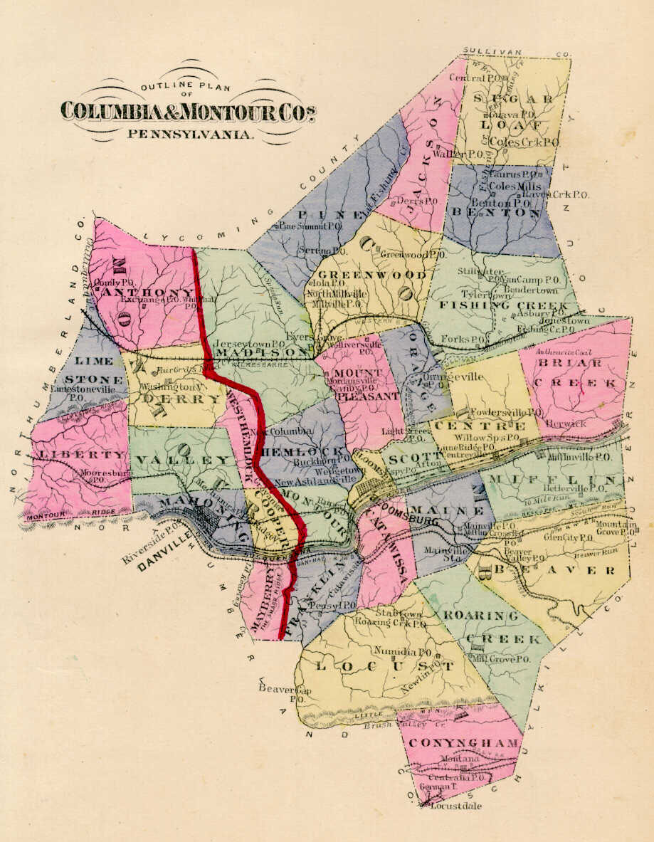
Fortunately, although the Land Office did not complete a warrantee map for Columbia County, a surveyor did complete a rough draft of approximately 90% of the original tracts of the county, creating one map for the northern section of the county and another for the southern portion (see below). Only the names of the warrantees are found on the two maps , which are faded, in poor condition, and illegible in small areas. As a service, we are posting the best copies available of both of the drawings, which are in the Pennsylvania Archives in Harrisburg. We are also posting a more detailed warrantee tract map which the draftsman created for parts of today's Beaver, Mifflin, Roaring Creek, and Main Townships. These are the only large connected tract maps showing the original landowners of Columbia County in the Pennsylvania Archives. We are also posting below images from the 1876 Atlas of Columbia and Montour Counties (scroll down to the bottom of the page) which can be used with the 1870 and 1880 census records, as well as Battle's 1887 History of Columbia & Montour Counties, Pennsylvania. These maps, found in the Library of Congress, are in the public domain but the images we have taken of the atlas posted below belong to us and are not to be used for commercial use. For those wishing to use them for personal use (including illustrating a family history you are working on), we give permission to use them, but we would appreciate attribution to Ancestor Tracks. It takes much time and effort to locate, process, and post these and the many other county images we have posted, so we expect and appreciate this courtesy. We hope that you will find this atlas a useful tool for when coupled with the 1860, 1870 and 1880 census and published county histories. Click on the township of your choice and once they have downloaded completely, click on them again to enlarge and clarify them. They may be saved to your computer by right-clicking and selecting "Save Image As..."
Keep in mind that Columbia Co. was created in 1813 from Northumberland, and the portion of Northumberland which became Columbia was originally part of Berks and Northampton Counties until 1772. Thus, all of these counties should be checked for deeds and wills, etc. You will find further details about the landowners shown on the maps below in the Indexes to the Warrant Registers located in the Pennsylvania Archives, which we have published on CD as First Landowners of PA: Colonial and State Warrant Registers in the PA Archives, Harrisburg, 1682-ca 1940 . The details in the Warrant Register indexes include several pieces of extremely inportant information for genealogists: (1) the size of the tract; (2) date of the warrant (or order which was issued by the colonial or state Land Office to have the tract surveyed for the warrantee); (3) date the survey was returned to the Land Office; (4) name of the patentee who received final title from the state after the survey was returned; (5) Warrant Register and page number where the warrant was registered; and (6) Survey Book and page number which the survey was copied into. The Columbia, Northumberland, Berks and Northampton County Registers are all contained on this CD. Once you have located relevant information for your ancestor's tract, you can write to the Pennsylvania Archives for copies of the original documents. The second resource we offer is First Landowners of Pennsylvania: Indexes to the Colonial and State Patent Registers in the PA Archives, Harrisburg, 1684-ca 1995. If you cannot find an original landowner's name in the Warrant Registers (also available on CD from Ancestor Tracks), this is the next place to look. Within an index covering the relevant years, the names are grouped alphabetically by the first letter of the patentee's surname, then grouped by volume number of Patent Book, and finally arranged chronologically by date of patent. Thus, you have to look through the entire alphabetical section (which may be as little as one page to as many as 50) to be sure you don't miss anyone. Please note that these registers predate the deed books located in each county because they deal with the first transfer of land to private individuals at the state level. Copies of all original documents shown in these indexes are available from the Pennsylvania Archives in Harrisburg.
The map we are posting shows the first person who applied to the colony or state for the land. After the title was transferred from the proprietors or the state government to private individuals (or patentees), all further land transactions were accomplished by deeds between two private parties, the grantor (seller) and grantee (buyer). These deeds are recorded at the county courthouses. Thus, if you find your ancestor's name in the Warrant Registers held by the state Land Office, you will probably also find him or her entered into subsequent land transactions recorded in Deed Registers at the county level. The Columbia County Historical & Genealogical Society is a wonderful society has a collection of over 2,800 records pertaining to land ownership in the county dating from 1768. They have posted abstracts of many of their records online. Click on �Additional Resources� then �Deeds and Drafts,� or go directly to http://www.colcohist-gensoc.org/mysql/deeds.php. Enter the surname of the family you are searching, or find all of the records for a particular township which are currently abstracted and online by entering only the township name. The Index also includes names of adjacent tract owners for some three hundred warrantee tracts. The historical society intends to continue posting these abstracts as time allows.
The Warrantee Map of Columbia Co., Pennsylvania is below. Click on the area of the county you wish to explore. Once the images are loaded, they can be enlarged by clicking on them, and they may be saved to your computer by right-clicking and selecting "Save Image As..."
Columbia County First Landowner Map |
|
Area Maps
|
South Portion
|
Click here to go to the Ancestor Tracks product page.
Click here to return to the Ancestor Tracks home page.