![]()
Our goal at Ancestor Tracks is to publish maps and land ownership information allowing genealogy researchers to place more precisely the locations where our ancestors lived. The state of Pennsylvania began platting the exact metes-and-bounds tracts of the earliest landowners, township-by-township, starting in 1907, but the Land Office only completed about 1/3 of the state before the project ended. Unfortunately, Pennsylvania did not plat the tracts of the earliest landowners of Franklin County.
In lieu of being able to bring you Township Warrantee Maps of the earliest settlers, we are posting free, downloadable images of the Atlas of Franklin County, Pennsylvania, From actual Surveys under the direction of D. G. Beers published by Pomeroy & Beers in 1868. We hope that it will be a useful tool for locating your Franklin County families when coupled with the 1860 and 1870 censuses and published county histories. The 1868 atlas is located in the Library of Congress. While the physical maps are in the public domain, the images we have personally taken by going to the Library of Congress belong to us and are not to be used commercially. If you wish to use them for personal use (including illustrating a family history you are working on, or including one on your personal web page for which you do not charge), you may use them freely as long as you attribute them to Ancestor Tracks.
Speaking of the censuses and county histories, the Franklin County USGenWeb Project has a wealth of information, including links to free online censuses and online copies of Bates' 1887 History of Franklin County, Pennsylvania (1,110 pages), Rupp's 1846 History and Topography of Dauphin, Cumberland, Franklin, Bedford, Adams, and Perry Counties, and Nevin's Centennial Biography, Men of Mark of Cumberland Valley, PA, 1776-1876. Also, don't overlook Jim Houpt's Indexing Project on this page.
If your ancestor was actually a first landowner in Franklin County, purchasing his or her property from the colony or state of Pennsylvania, further information about these tracts may be gleaned from the Warrant Register and Patent Register on file at the Pennsylvania Archives in Harrisburg and available on CD from Ancestor Tracks. Once you have obtained the Survey Book and page number, you can view a copy of the original survey online courtesy of the Pennsylvania State Archives Reference Section headed by Jonathan Stayer. If your ancestor settled before Franklin Co. was created in 1784, check in the Cumberland Co. registers which are also included on these CDs. It they settled in the county before Cumberland was formed in 1750, check the Lancaster Co. register/ledger. The earliest land warrants were filed under the county as it existed at the time the warrant was issued. Keep in mind that all sales of land after the state or colony transferred ownership to private individuals are recorded at the county courthouse.
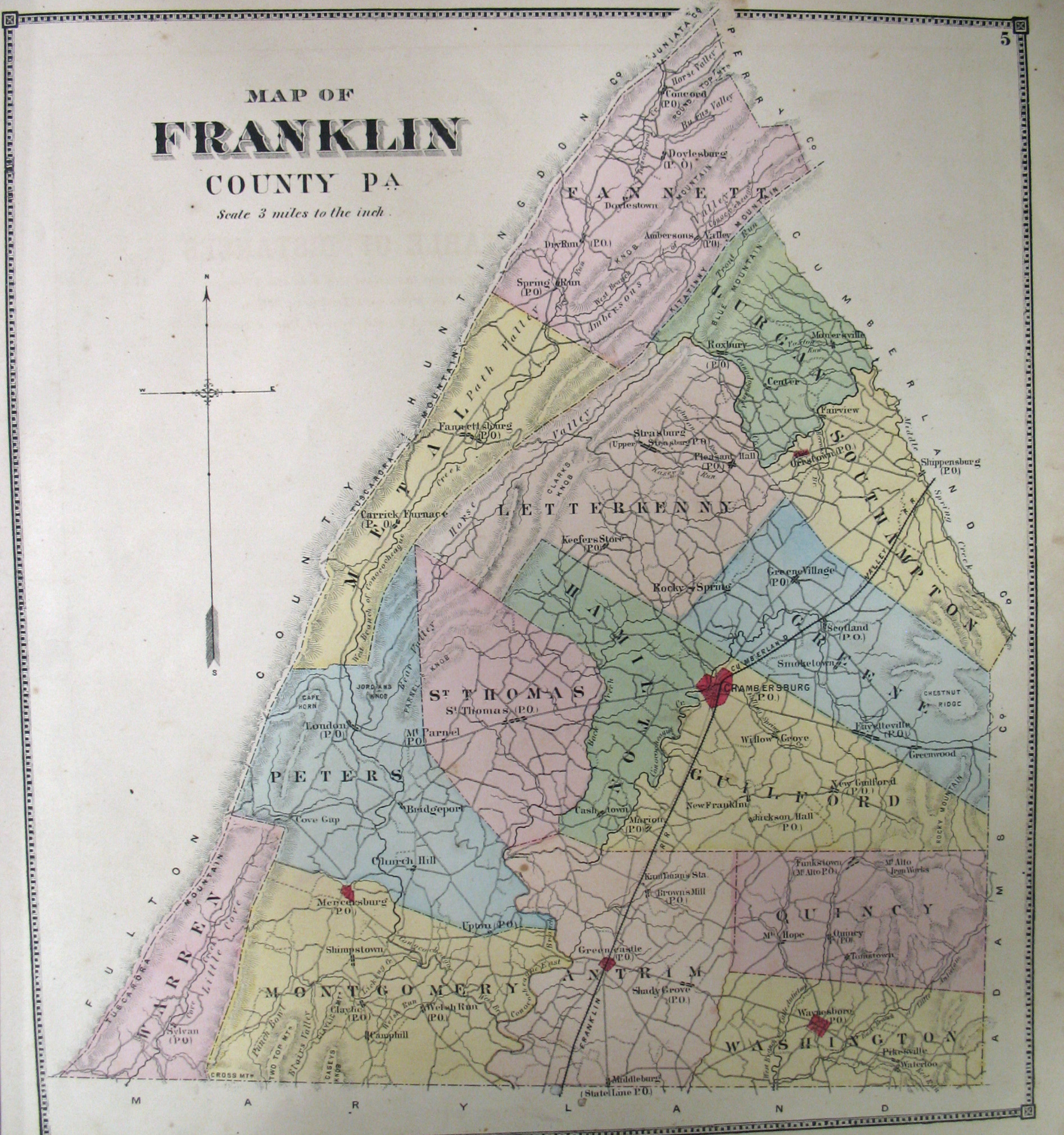
Click twice to enlarge
Images of the 1868 Atlas of Franklin County are below. Click on the township of your choice. Once the images are loaded, they can be enlarged by clicking on them, and they may be saved to your computer by right-clicking and selecting "Save Image As..."
Franklin County, 1868 |
|
Township Maps
|
|
| Boroughs, Towns and Villages | Greencastle Mercersburg Waynsboro |
Click here to go to the order form.
Click here to go to the product page.
Click here to return to the home page.