![]()
The state of Pennsylvania began platting the exact metes-and-bounds tracts of the earliest landowners, township-by-township, starting in 1907, but the Land Office only completed about 1/3 of the state before the project ended. Fortunately for some researchers, state draftsmen completed Township Warrantee Maps for about half of Northumberland County. Scroll down this page for links to the existing Warrantee Township Maps.
If your ancestor was actually a first landowner, purchasing his or her property directly from the colony or state of Pennsylvania, further information about these tracts may be gleaned from the Warrant and Patent Registers of Northumberland County and its parent counties (Northumberland was created in 1772 from parts of Berks, Cumberland, and Lancaster Counties). These Warrant and Patent Registers are contained on our CDs, First Landowners of PA: Colonial and State Warrant Registers in the PA Archives, Harrisburg, 1682-ca 1940 and First Landowners of Pennsylvania: Indexes to the Colonial and State Patent Registers in the PA Archives, Harrisburg. Keep in mind that the original Northumberland County encompassed vastly more territory than it does today, originally including nearly half the state.
For much more information regarding Northumberland County, the entire 1891 History of Northumberland County, Pennsylvania, edited by Herbert C. Bell has been transcribed and placed online by Tony Rebuck.
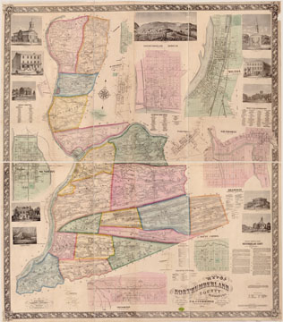
As part of our goal of uncovering maps which can be used with census records to help pinpoint where our ancestors lived, we are posting here the Map of Northumberland County, Pennsylvania From Actual Surveys by G.M. Hopkins which was published in 1858. This map, found in the Library of Congress, is in the public domain but the images we have taken of it posted below belong to us and are not to be used for commercial use. For those wishing to use them for personal use (including illustrating a family history you are working on), we give permission to use them, but we would appreciate attribution to Ancestor Tracks. It takes much time and effort to locate, process, and post these and the many other county images we have posted, so we expect and appreciate this courtesy. We hope that you will find this atlas a useful tool when coupled with the 1860, 1870 and 1880 census and published county histories. Click on the township of your choice and once they have downloaded completely, click on them again to enlarge and clarify them. They may be saved to your computer by right-clicking and selecting "Save Image As..."
Northumberland County Landowner Map, 1858
The following Township Warrantee Maps which show the metes-and-bounds tracts of the first settlers were drawn by draftsmen in the Pennsylvania Land Office. These are large images and will take time to download. It appears that these are the only townships for which Commonwealth of Pennsylvania draftsmen connected the surveys and patents and created a complete Township Warrantee Map. If any researcher knows of additional land resources for the missing townships, please contact customer_service@ancestortracks.com.
| Northumberland Co. Township Warrantee Maps |
|
Click here to go to our order form.
Click here to go to our product page.
Click here to return to our home page.