![]()
|
Unfortunately, the state of Pennsylvania did not plat the original warrantees and patentees on Union County township maps, other than for White Deer Township. However, there is a very large map hanging in the upstairs hallway of the Union County Courthouse which shows the first landowners. We are very somewhat indistinct images of that map (see bottom of page), as well as excellent downloadable images of the Pomeroy & Beers 1868 Atlas of Union & Snyder Counties, Pennsylvania, to aid in Union Co. research.We hope that the atlas will be a useful tool for locating your Union County families when coupled with the 1860 and 1870 census. It should also be an indispensible aid when used in conjunction with John Blair Linn's Annals of Buffalo Valley, Pennsylvania which was published in 1877 and mentions many of the owners found in this 1868 atlas. Google Books has also posted a copy of Annals which can be downloaded to your computer as a .pdf file, as well as a complete downloadable PDF index by Mary Belle Lontz. If your ancestor was actually a first landowner (warrantee or patentee), purchasing his or her property from the colony or state of Pennsylvania, his/her land acquisition should be documented at the state level, not at the county level. Union Co. was created in 1813 from Northumberland Co., while Northumberland was created in 1772 from portions of Cumberland, Northampton, Lancaster, Berks, and Bedford Counties. These dates are important, as the earliest land warrants were filed under the county as it existed at the time the warrant was issued. Thus, all of the relevant Indexes to Warrant Registers, published as First Landowners of PA: Colonial and State Warrant Registers in the PA Archives, Harrisburg, 1682-ca 1940 , as well as the Indexes to Patent Registers, should be searched to find the first landowners. Once you know the Survey Book and page number, be aware that the Pennsylvania Archives in Harrisburg, under the direction of Jonathan Stayer, has posted images of both the front and back side of every page of the Copied Survey Books online. Check both the front and back of the relevant survey. These surveys can be printed.
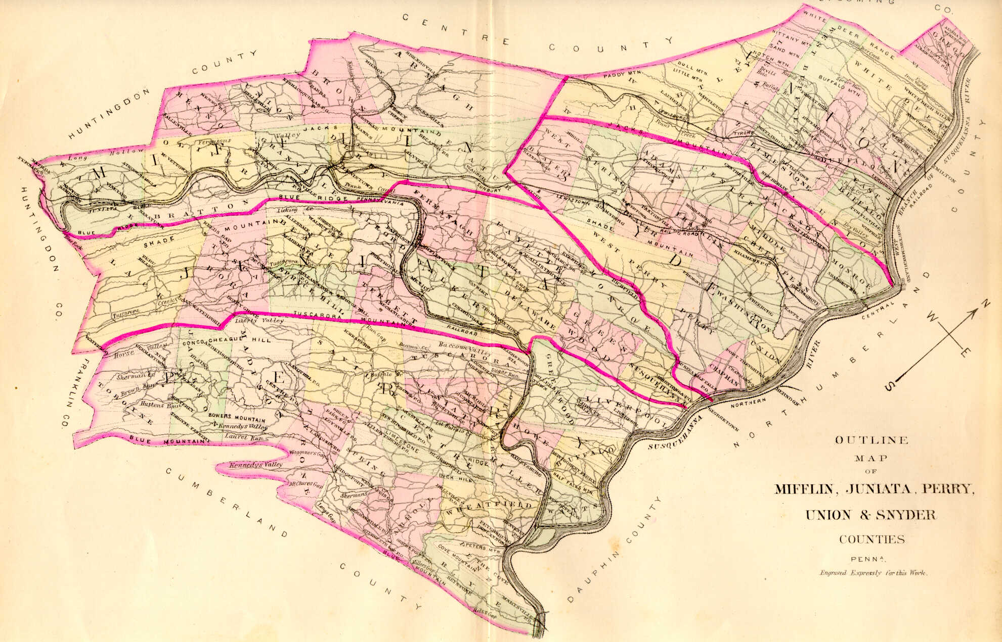
Images of the 1868 Atlas of Union & Snyder Counties are below. Click on the township of your choice. Once the images are loaded, they can be enlarged by clicking on them, and they may be saved to your computer by right-clicking and selecting "Save Image As..."
The second series of images is my attempt to publicize the large, framed warrantee map which is posted on the wall in the Union County Court House. I took numerous photographs of the hanging map and tried to stitch them together, but the results are less than satisfactory. Nevertheless, I am posting these images with the hope that researchers will at least know that it is available and may be able to ask the Union Co. Historical Society (which is on the same floor in the courthouse) to take a picture of the desired portion of the map. I am posting seven "strips" of photos which overlap each other. They number from 1-7 showing the tracts from the top of the county to the bottom. Also, we are indebted to Eric Wagner of Mifflinburg who wrote the following clarification regarding the map. Many thanks, Eric!
It appears that White Deer is the only township for which Commonwealth of Pennsylvania draftsmen connected the surveys and patents and created a complete Township Warrantee Map. It can be ordered for $48 + $10 for shipping and handling as follows: Pennsylvania State Archives | ||||||||