![]()
Our goal at Ancestor Tracks is to publish maps and land ownership information allowing researchers to pinpoint where our ancestors lived. In 1907, the state of Pennsylvania began platting the exact metes-and-bounds tracts of the earliest landowners, township-by-township. They only completed these Warrantee Maps for about 1/3 of the land mass of Pennsylvania, and Warren County is one of the completed counties. The Pennsylvania Archives has been so kind as to post these images online (scroll below for links to these Warren County Township Warrantee Maps).
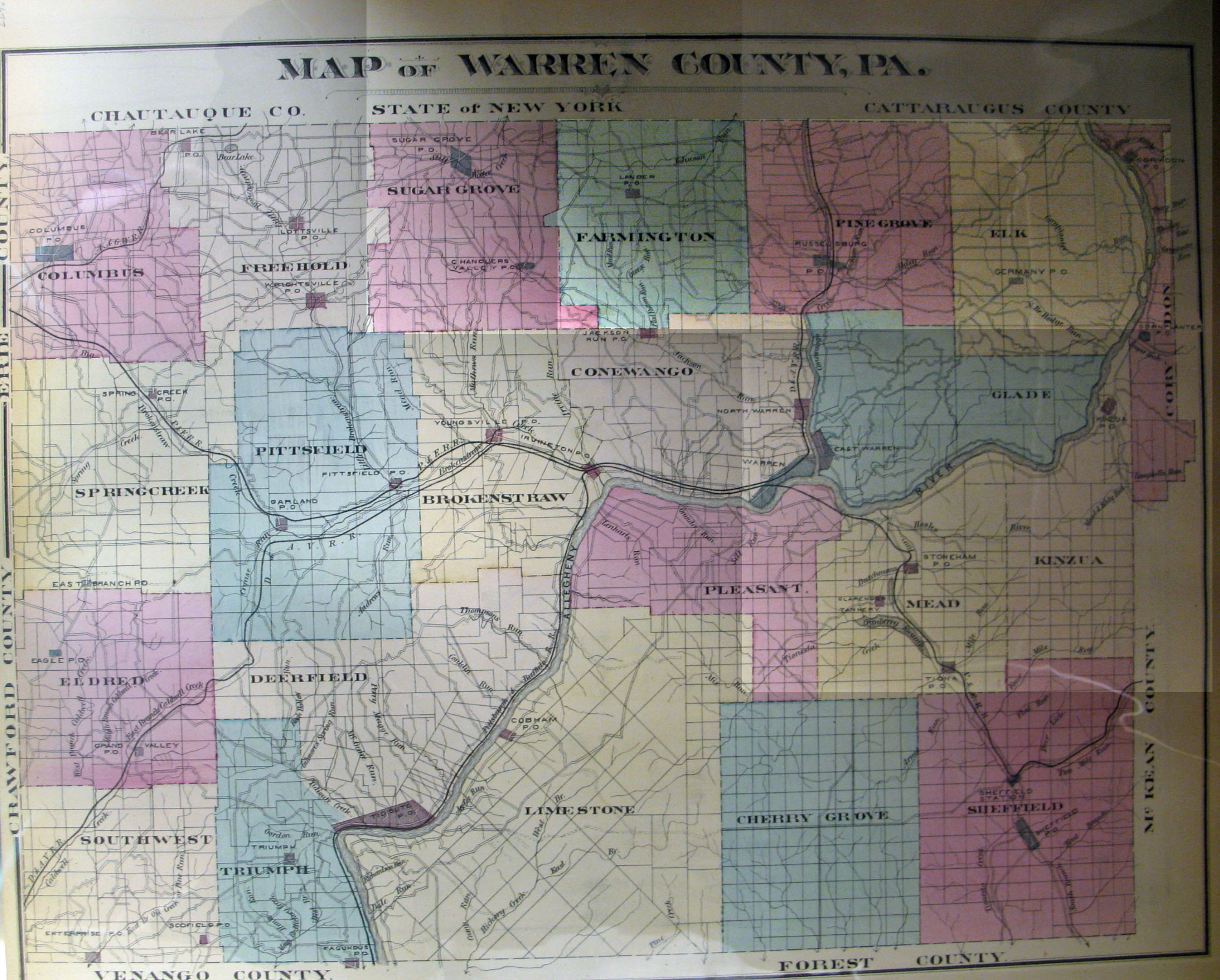
In addition to links to the Warrantee Maps, we are posting free, downloadable images from the 1878 Howden & Odbert's Atlas of Warren County, Pennsylvania from Actual Surveys & Records by & under the directions of J. A. Howden & A. Odbert (Washington, PA: F. G. Longdon and Wilson Porter, 1878). We hope this landowner map will be useful when coupled with the 1860, 1870 and 1880 censuses and published county histories such as the free, downloadable 1887 History of Warren County, Pennsylvania with Illustrations and Biographical Sketches of Some of its Prominent Men and Pioneers edited by J. S. Schenck (Syracuse, NY: D. Mason & Co., Publishers, 1887; online courtesy of Internet Archives). A second version of this history of Warren Co. has been posted online at PA-Roots--many thanks to Nathan Zipfel for his outstanding work!
Please note that the 1875 atlas that we are posting below, on file in the Library of Congress, is in the public domain but the images we have taken belong to us and are not to be used for commercial use. For those wishing to use them for personal use (including illustrating a family history you are working on), we give permission to use them, but we would appreciate attribution to Ancestor Tracks. It takes much time and effort to locate, process, and post these and the many other county images we have posted, so we expect and appreciate this courtesy.
Click on the township of your choice and once they have downloaded completely, click on them again to enlarge and clarify them. They may be saved to your computer by right-clicking and selecting "Save Image As..."
1878 Landowner Atlas of Warren County
| |
| Townships | Brokenstraw Township Cherry Grove Township Columbus Township Conewango Township Corydon Township Deerfield Township Eldred Township Elk Township Farmington Township Freehold Township Glade Township Kinzui Township Limestone Township Mead Township Pine Grove Township Pittsfield Township Pleasant Township Sheffield Township Southwest Township Spring Creek Township Sugar Grove Township Triumph Township |
| Towns and Villages | Bear Lake Chandlers Valley Claridon Columbus Corydon East Spring Creek Enterprise Fagundus Farmington Center Garland Grand Valley Irvineton Kinzua Lottsville Lower Smithfield Pittsfield Russelsburg Sheffield Sugar Grove Wrightsville Youngsville |
| Business Directory | Page 1 Page 2 Page 3 Page 4 Page 5 Page 6 Page 7 Page 8 Page 9 Page 10 Page 11 Page 12 Page 13 Page 14 Page 15 Page 16 Page 17 Page 18 Page 19 |
Warrant Register: A search of the Last Purchase Register did not reveal a warrant for Aaron Dale, but he is listed in the Allegheny County Warrant Register. His entry (under the letter "D") in the ledger shows that he received a warrant for 400 acres on 10 Apr 1793, that the survey containing 434 acres was returned for patenting 7 Feb 1799 to Wilhelm Willink. It confirms that the patent was recorded in Patent Register P38, pg. 195, and that the survey was recorded in Survey Book C46, pg. 112. According to the Allegheny Co. Warrant Register, a remarkable number of Dales were awarded separate warrants on that 10 April date: Sarah, Jonas, David, Daniel, Eliza, Noah, Hannah, Ann, Philip, Isaac, Peter, Israel, Grace, Roger, John, George, Elihu, James, Matthew, Aaron, Enoch, Owen, Paul, Edward, Aaron, Mark, Samuel, Benjamin, Robert, John, Nathan, Moses, George, Richard, William, Mary, Simon, Caleb, Luke, and Lydia. All of these tracts were patented to Wilhelm Wilink between 30 January and 11 February 1799--highly coincidental indeed, especially given the new law of 1799 tightening the requirements! None of these names are mentioned in the chapter on Brokenstraw Township in the History of Warren County (pp. 401-420) which details nearly all of the settlers prior to 1806 in the township.
Survey: Survey Book C46, pg. 112. The survey shows that his tract was surrounded by those of Matthew Dale, Israel Dale, Noah Dale and Jonas Dale.
Patent: The index to Patent Register P38, pg. 195, confirms that Wilhem Willink, et. al., patented 434 acres called "Elk-Lick" on 8 Feb 1799 which had been warranted to Aaron Dale on 10 Apr 1793. The numbers on the tracts in the 1878 atlas refer to numbers assigned to the tracts purchased under the 1784 "Last Purchase" and the sale warrants are recorded in the Last Purchase Warrant Register at the Pennsylvania Archives in Harrisburg. The warrants can be searched by scrolling through the pages under the first initial of the surname of the purchaser. Thus, Tract #2579 appears on pg. 48 (under "W") which verifies that it was granted on 12 Dec 1792 to "Willink, Wilhem and others" with an estimated size of 900 acres. The survey was returned for patenting to Silas X. Billings on 20 Apr 1874 with an actual size of 1002 acres. It confirms that the Patent was recorded in Patent Register H72, pg. 672 (since the patentee was Silas Billings, his patent was indexed under the letter "B" in the Patent Index Registers). The last column in the Last Purchase Register shows that the survey is recorded in Survey Book D7, pg. 127, which has been posted online with all other surveys by the Pennsylvania Archives. See the explanation of the Last Purchase of 1784 on our Elk County page and a map showing the Last Purchase counties in yellow).
Copies of the original warrant, survey (the one posted online is the version copied into Survey Books), and patent are available from the Archives.
| Warren Co. Township Warrantee Maps Repository: Pennsylvania Archives, Harrisburg |
Township | Brokenstraw Township Cherry Grove Township Columbus Township Conewango Township Deerfield Township Eldred Township Elk Township Farmington Township Freehold Township Glade Township Limestone Township Meade Township (North) Meade Township (South) Pine Grove Township Pittsfield Township Pleasant Township Sheffield Township Southwest Township Spring Creek Township Sugar Grove Township Triumph Township Watson Township (northern part of Limestone Twp. until 1880, thus not shown separately on the 1875 map above) |
Click here to return to the Ancestor Tracks home page.
Click here to go to the Ancestor Tracks order form.
Click here to go to the Ancestor Tracks product page.