Fayette County Maps
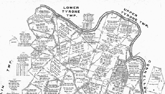
Fayette County is one of about one-third of PA's counties for which Township Warrantee Maps exist. Starting in 1907, the Pennsylvania Land Office began a project to research the original surveys and locate them once and for all on maps of current townships. Over many years, each Township Warrantee Map was painstakingly platted by draftsmen from the original warrants, surveys, and patents. The maps show precise outlines of each original tract and all surrounding tracts in the township, giving the names of the warrantee and patentee; dates of the warrant, survey, and patent; and the patent book and page of the recorded patent.
This Fayette County atlas contains one chapter for each of the county's 26 townships. Each chapter begins with the Township Warrantee Map reduced to 8 ½ X 11" with an atlas coordinate grid superimposed on the map and is followed by all of the information found on the map.
If your ancestors lived in Fayette County in the 19th century, check out the 1872 Atlas of the County of Fayette and the State of Pennsylvania, by G.M. Hopkins & Co., Philadelphia.
Click here to go to the Ancestor Tracks order form.
Click here to go to the Ancestor Tracks product page.
Click here to return to the Ancestor Tracks home page.