Washington County Maps
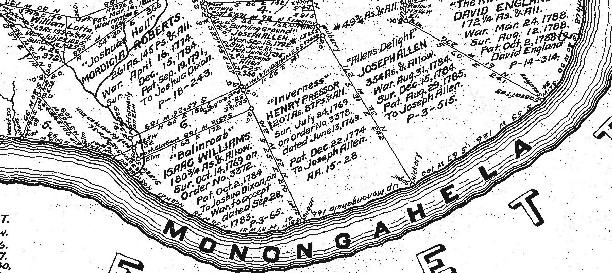
Starting in 1907, the Pennsylvania Land Office began a project to research the original surveys and locate them once and for all on maps of current townships. Over many years, each Township Warrantee Map was painstakingly platted by draftsmen from the original warrants, surveys, and patents. The maps show precise outlines of each original tract and all surrounding tracts in the township, giving the names of the warrantee and patentee; dates of the warrant, survey, and patent; and the patent book and page of the recorded patent.
This Washington County atlas contains one chapter for each of the county's 33 townships. Each chapter begins with the Township Warrantee Map reduced to 8 ˝ X 11" with an atlas coordinate grid superimposed on the map and is followed by all of the information found on the map (sample page).
|
The large images (averaging about 3' X 4') without coordinates are contained on a companion CD available for a nominal price.
|
|
When you find your ancestors' tracts, your first step is to check two sources for details about their lives: (1) Boyd Crumrine's 1882 History of Washington County, PA which has an absolute wealth of information about early residents, and (2) the University of Pittsburgh/Historical Society of Western Pennsylvania's online library which has 512 books on Pennsylvania history online, completely searchable. If your ancestors were present in Washington County in the later 1800's, use Caldwell's Historical Atlas of Washington Co. of 1876 in conjunction with Crumrine's 1882 history. Lastly, as we have done for numerous Pennsylvania counties (hover over each county on the PA map on our home page), we are posting completely free, downloadable township images from the 1856 Barker's Map of Washington County, Pennsylvania, From actual surveys by James M. Sherman & A.R. Day. This map, found in the Library of Congress, is in the public domain but the images we have taken of the atlas posted below belong to us and are not to be used for commercial use. For those wishing to use them for personal use (including illustrating a family history you are working on), we give permission to use them, but we would appreciate attribution to Ancestor Tracks. It takes much time and effort to locate, process, and post these and the many other county images we have posted, so we expect and appreciate this courtesy. We hope that you will find this atlas a useful tool for when coupled with the 1850, 1860 and 1870 census and published county histories. Click on the township of your choice and once they have downloaded completely, click on them again to enlarge and clarify them. They may be saved to your computer by right-clicking and selecting "Save Image As..." Click here to go to the order form.
Click here to go to the product page.
Click here to return to the home page.