![]()
|
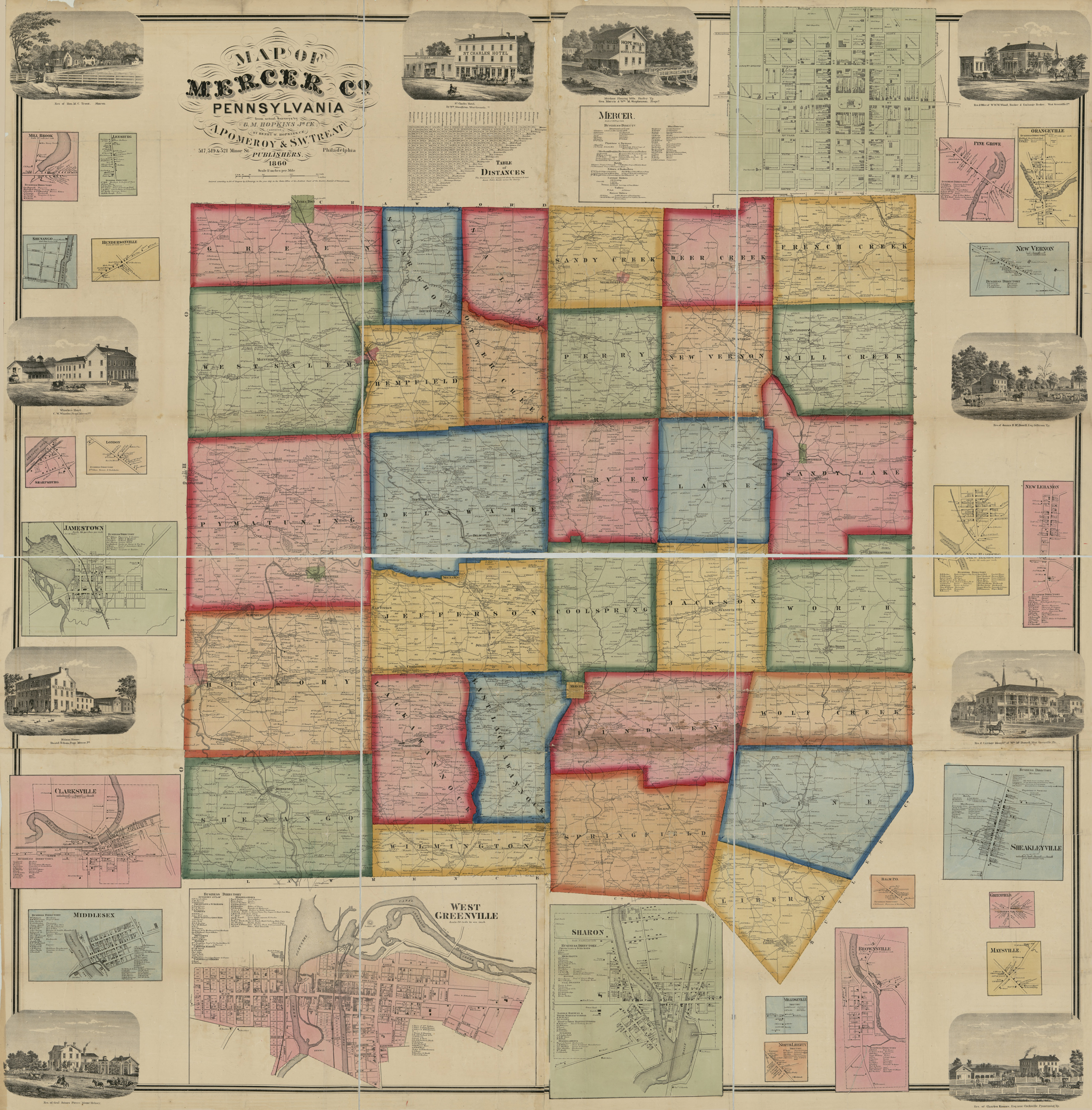
Our goal at Ancestor Tracks is to publish maps and land ownership information allowing researchers to place more precisely the locations where our ancestors lived. The state of Pennsylvania began platting the exact metes-and-bounds tracts of the earliest landowners, township-by-township, starting in 1907, but the Land Office only completed about 1/3 of the state before the project ended. Mercer County, fortunately, is one of the counties whose earliest landowners were completely platted. The Pennsylvania Archives, under the direction of Jonathan Stayer, has generously posted images of these maps showing the earliest landowners. Links to each township map are below. This area was part of the Donation Lands given to Revolutionary War soldiers based on their rank, so locating an ancestor here definitely warrants further research into Revolutionary War records. Any Revolutionary War pension or service record will probably be on file in state archives rather than federal records since the land was given by the state of Pennsylvania. Note that land records may be the only piece of evidence that your ancestor served in the Revolutionary War! We are posting images from Map of Mercer Co, Pennsylvania by G. M. Hopkins which was published in 1860. This map is located in the Library of Congress Geography and Map Division Washington, D.C. We hope that it will be a useful tool for locating your Mercer County families when coupled with the 1860, 1870 and 1880 census records. Once you click on an image and it is on your screen, it can usually be enlarged by clicking on the image, and it may be saved to your computer by right-clicking and selecting "Save Image As..." Images from the 1873 Combination Atlas of Mercer County and the State of Pennsylvania are online at the Mercer Co. U.S. Genweb Maps Project site. Many thanks are due to the wonderful people who scanned these images and are making them available to researchers! This 1873 atlas should be used when you find your ancestors on the 1850-1880 censuses, as well as published county histories. Twentieth Century History of Mercer County, Pennsylvania by F. G. White, 1909 (560 pages) can be downloaded at Google Books (hover over "EBOOK - FREE" and click on for "Download EPUB, PDF"; type the password that you see exactly as it is, and it will download to your computer. Open it to read it. If you want to keep a copy, you must save it to your computer! If you don't save it before you close out of the file, it will not be saved. Many of the families documented in this book are shown on the 1873 atlas. The 1888 History of Mercer County does not appear to be online at this time, but Teri Brown maintains an excellent "Mercer County Genealogy" page on rootsweb. Pay special attention to how the townships evolved over time. Thank you, Teri, for the incredible wealth of resources you are bringing to researchers of Mercer County families! Mercer County was created in 1800 from Allegheny County which was itself created in 1785 from Washington and Westmoreland Counties (Mercer was in the Westmoreland Co. area). Thus, for any pre-1800 settlers, check Allegheny County and Westmoreland County for deeds and wills, etc. If your ancestor was actually a first landowner, purchasing his or her property from the colony or state of Pennsylvania, further information about these tracts may be gleaned from the Mercer or Allegheny or Westmoreland County Warrant Registers contained on our CD, First Landowners of PA: Colonial and State Warrant Registers in the PA Archives, Harrisburg, 1682-ca 1940 (see below). Mercer County Landowner Map by Hopkins, 1860
As mentioned above, the Pennsylvania Archives has posted Warrantee Maps showing the very first landowners for all of the townships of Mercer County. Unfortunately, they are not indexed.Please note that these land transfers were from the colonial or state government to the first private landowners. These transactions predate the deed books located in each county which show transactions from one person to another person. Scroll down to below the table to learn how best to use these Warrantee Maps to gain the maximum information regarding your ancestor's tract.
Can we find out more about Pvt. Samuel Allen? The original Donation Land Registers have been posted. We know the number of Allen's tract (676) so the easiest approach is to look under "Numerical Listing of Donation Land Tracts" under District 4. If the survey book and page number had not been entered on the Warrantee Map, this would be the only source to locate it. Under "Listing of Veterans Entitled to Land," pg. 1, we see that Samuel Allen served in the 1st Battalion of Infantry as a private. A search through "Donation Claimant Papers" under "Surnames beginning with 'A" brings up the image of the original 2 Oct 1786 Power of Attorney granted (and signed) by Samuel Allen (pg. 28). He granted power to Mr. Richd Renshaw to "Act in all Cafes Nefary" to obtain a patent for his donation land and shows that he was in the Pennsylvania Line. Witnesses were Thomas Johns and William Jones. These papers are not indexed or alphabetized under the letter A, so they must be examined individually. Also, look in Twentieth Century History of Mercer County, Pennsylvania for family information and search the Digital Library of Historic Pittsburgh as well as the published Pennsylvania Archives (free on Fold3). Obviously, not all of the land in Mercer Co. went to soldiers. Adjoining Allen at the southeast corner in Coolspring Twp. is Aaron Church. According to this Warrantee Map, Church received a warrant dated 21 Apr 1794, it was surveyed 23 May 1795 (recorded in Survey Book C29, pg. 108), and it was patented 11 July 1826 to Robert Bowman (recorded in Patent Register H23, pg. 623). Sometimes there are many years between each of the three steps (warrant, survey & patent) in finalizing the title of the first landowner and the tract may have passed through several hands before the patent is granted since each step involved paying a fee; in this case it officially passed to another owner long after church warranted it, but it may have passed through several hands unofficially. If you would like a copy of the original warrant, survey, and patent, you can order copies from Harrisburg. Pennsylvania Historical & Museum Commission
Click here to go to the Ancestor Tracks product page.
| ||||||||||||||||||||||||||||||||||