![]()
|
Our goal at Ancestor Tracks is to publish maps and land ownership information allowing genealogy researchers to place more precisely the locations where our ancestors lived. The state of Pennsylvania began platting the exact metes-and-bounds tracts of the earliest landowners, township-by-township, starting in 1907, but the Land Office only completed about 1/3 of the state before the project ended. We are incredibly fortunate that, while Pennsylvania did not plat the tracts of the earliest landowners of Somerset County, it was taken on as a project by the Works Progress Administration (WPA). We are posting those maps below.
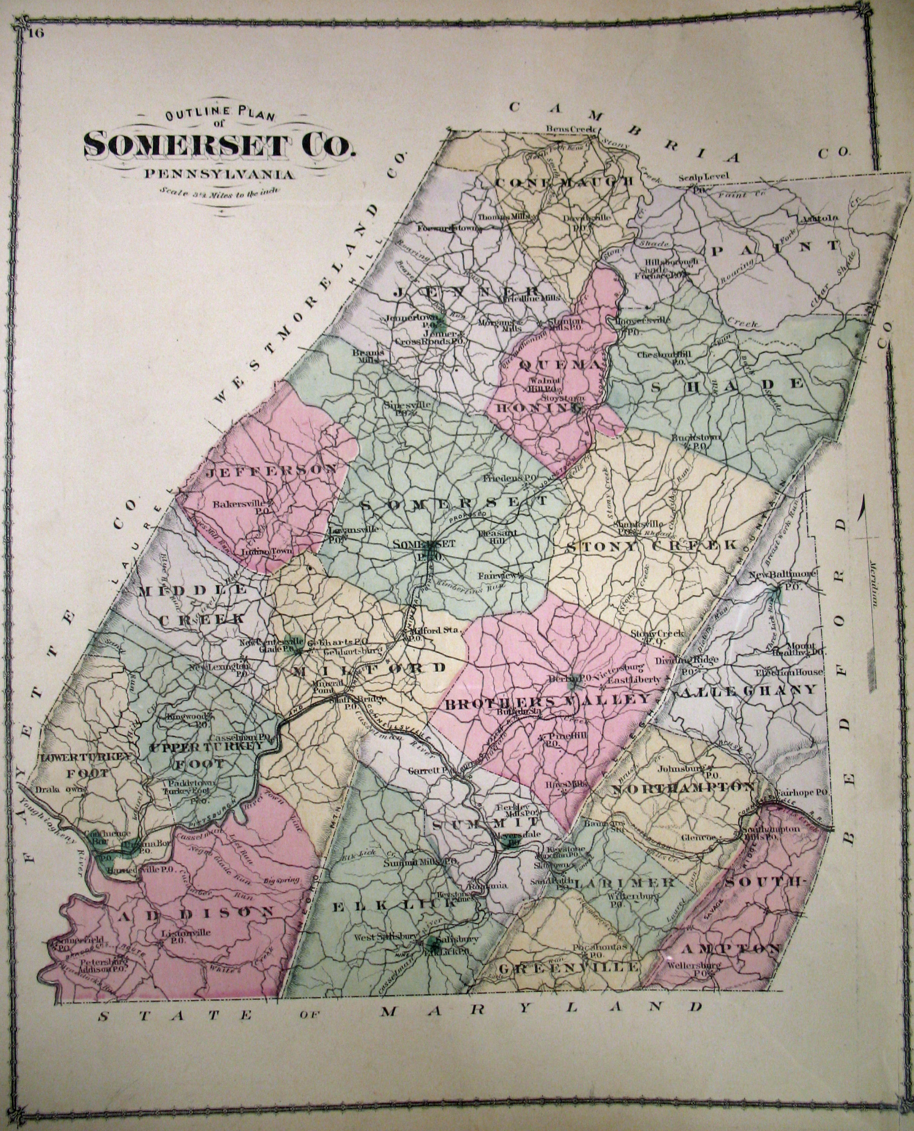
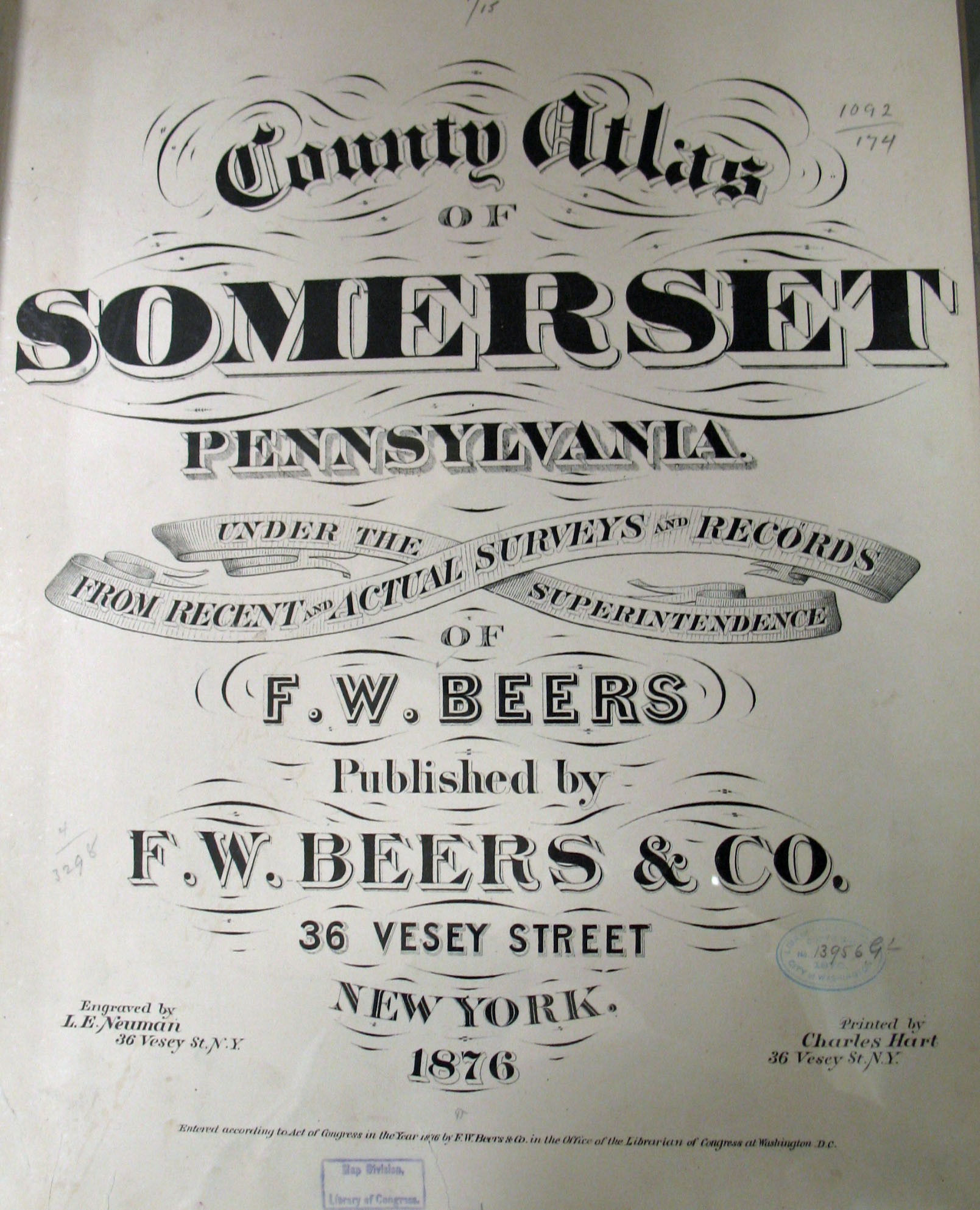
In addition, we are posting free, downloadable images of the County Atlas of Somerset, Pennsylvania published by F. W. Beers & Co. in 1876. We hope that it will be a useful tool for locating your Somerset County families when coupled with the 1860 and 1870 censuses and published county histories. The 1876 atlas is located in the Library of Congress. While the physical maps are in the public domain, the images we have personally taken by going to the Library of Congress belong to us and are not to be used commercially. If you wish to use them for personal use (including illustrating a family history you are working on, or including one on your personal web page for which you do not charge), you may use them freely as long as you attribute them to Ancestor Tracks. Speaking of county histories, History of Bedford and Somerset Counties, Pennsylvania can be downloaded as a pdf file. If your ancestor was in the county before 1795 while it was still part of Bedford County, check out the website "Mother Bedford" maintained by Larry D. Smith. Larry has written extensively about early Bedford Co. and has posted much research, especially about early settlers and the Revolutionary War. Finally, the Pennsylvania Archives in Harrisburg has posted the 1860 Map of Somerset County by Edward L. Walker. There are 9 sections to the map--click on the section you are interested in and it will enlarge.
Images of the 1876 County Atlas of Somerset, Pennsylvania are below. Click on the township of your choice. Once the images are loaded, they can be enlarged by clicking on them, and they may be saved to your computer by right-clicking and selecting "Save Image As..."
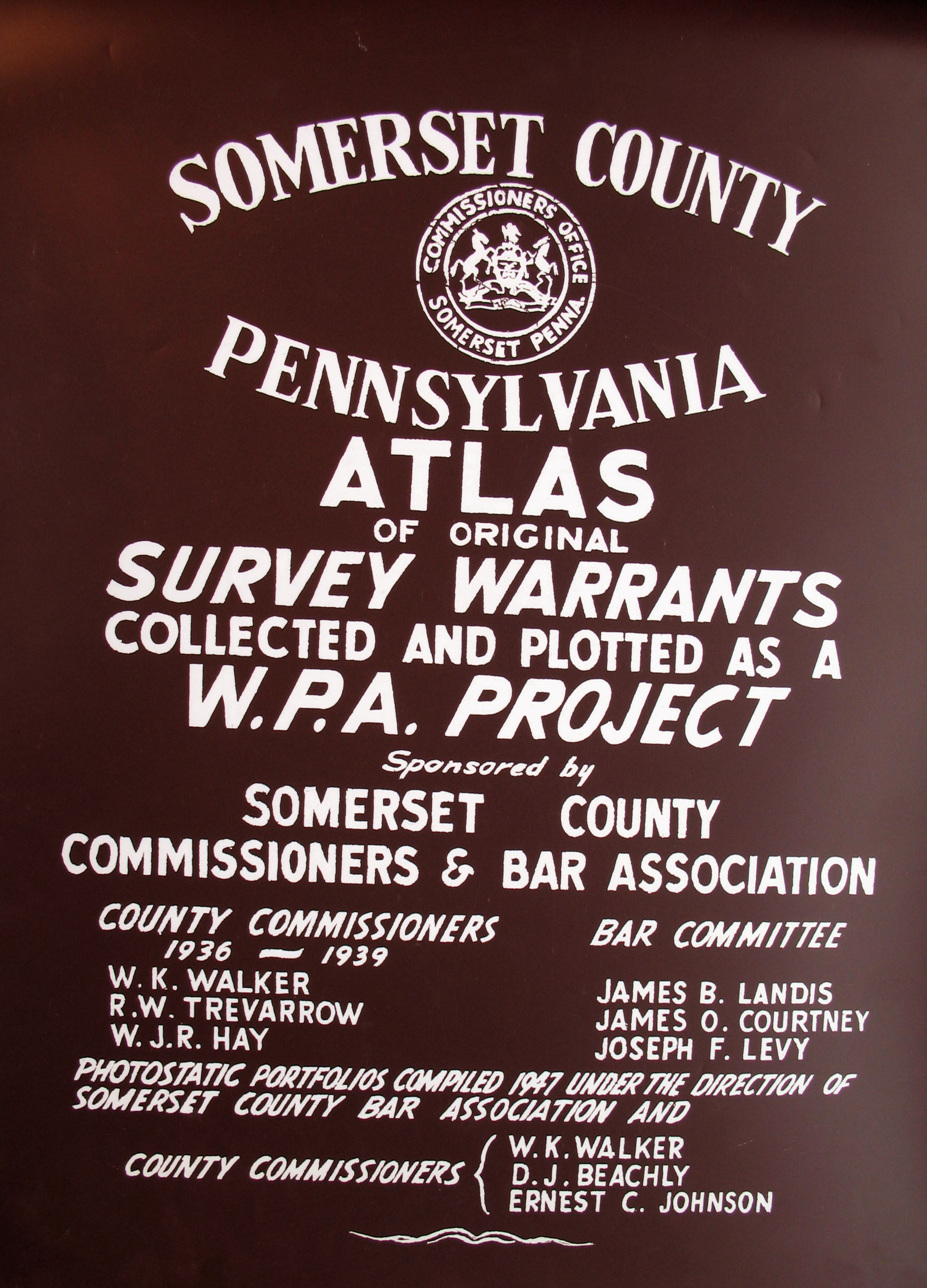
A copy of Somerset County Atlas of Surveys and Warrants Collected and Plotted as a WPA Project, published in 1939, is located in the Office of Recorder of Deeds in Somerset. We purchased copies of the maps which we are posting here--we were assured these were the best copies available, although some of the writing is difficult to decipher. Only one township has been indexed, and if anyone creates an index for a township, we would be thrilled to post it! In the meantime, thank you very much, Tim Fisher, for taking the time to create this index for Lower Turkeyfoot Township! As Tim says, "A whole slew of the folks from Somerset Co., PA wound up in Perry Co., OH." He should know since his grandmother was treasurer (and informal historian) of Perry Co. for 35 years who passed her extensive sources down to Tim, including her information on the Goodin family who came to Somerset Co. from Snyder Co., PA, and then moved on to Perry Co., OH. He has two websites for Perry County, Ohio: an interactive database with 22,000 individuals, and genealogy-related sources for Perry County (click on "Content" tab for amazing sources--all scanned and free!). Do NOT miss his sites if your ancestors were here! Somerset Co. was created in 1795 from Bedford County after so many people moved into the area that it became necessary to open a new seat of government for them. Prior to 1771 when Bedford was created, the area belonged to Cumberland Co. Thus, all of these counties should be checked for deeds, wills, etc. If your ancestor was actually a first landowner, purchasing his or her property from the colony or state of Pennsylvania, he or she should be on these warrantee maps drafted under the WPA. Information on most tracts is as follows: (1) Name of the warrantee, (2) size of the tract, (3) warrant date, and (4) usually the survey date. With this data, you can find out more about the first owner(s) of the tract; then you can compare it to the 1876 atlas we are posting above to find the location of the tract. Here is the process:
Once the images are loaded, they can be enlarged by clicking on them, and they may be saved to your computer by right-clicking and selecting "Save Image As..." Please note that we are including two images for the townships of Somerset and Stoneycreek because quite a few entries were written upside-down.
Click here to go to the order form.
|