Berks County: Atlas of Early Landowners of Berks County
2020 Revision Published by Ancestor Tracks
(scroll down for free 1860 landowner atlas)
Ancestor Tracks is committed to becoming a one-stop resource for researchers of early Pennsylvania landowners. In addition to publishing our own books, we are posting images of 19th century maps and atlases that we personally took in the Library of Congress. Our goal is to post landowner maps, or links to other websites with landowner maps, for every county in the state.
Original Land Owners
On this page, you will find the latest revision (2020) of our atlas (first published in 2007) for sale, showing the metes-and-bounds tracts of the very first owners of land in Berks County. It contains all of the Township Warrantee Maps drafted by the Pennsylvania Land Office in the early 1900s.
The draftsmen at the Pennsylvania Land Office painstakingly platted each original tract into current township boundaries using the Warrant and Patent Registers to create the Warrantee Maps. They searched each county and parent county, then each alphabetical section chronologically, in the set of 67 county Warrant Registers plus 3 pre-1733 ledgers called First Landowners of PA: Colonial and State Warrant Registers in the PA Archives, Harrisburg, 1682-ca 1940 ($35) which can now be downloaded and saved to your computer. (Free images are also posted on the Pennsylvania State Archives website where each page of each county’s ledger is a separate pdf file). The Pennsylvania State Archives has posted the free online surveys (check both front and back sides) and you can order copies of the original documents from the Pennsylvania State Archives in Harrisburg using their order form. The draftsmen also searched Pennsylvania’s index to Patent Registers ($35). Within an index covering the relevant years, the names are grouped alphabetically by the first letter of the patentee’s surname, then grouped by volume number of Patent Book, and finally arranged chronologically by date of patent. Thus, the entire alphabetical section must be searched (which may be as little as one page to as many as 50) so as not to miss anyone.
See our explanation of how land was transferred from the government to individual owners from the earliest days of settlement.
The maps show precise outlines in metes and bounds of each original tract and all surrounding tracts in the township, giving the names of the warrantee and patentee; dates of the warrant, survey, and patent; and the patent and survey books and page of the recorded patent. Please be aware, however, that the state only platted 23 townships, or just over half of the county, before the project came to a halt. Therefore, similar maps from several other sources, although with less information regarding the tracts, have been added to this volume.
We have added our own research to the resources on Oley, Centre, Maxatawny, and Rockland Townships to make them complete, but some work remains to be done on the remaining maps. The result is that original plats of the earliest landowners of over 75% of the county can be found in this book.
Each chapter begins with the Township Warrantee Map produced by the state draftsmen. A second map follows, cropped to eliminate marginal information, with atlas coordinates superimposed upon it. The third map for each township, which was formerly available only on a companion CD at separate cost, consists of modern road maps superimposed on the warrantee map by the Berks County GIS Department.
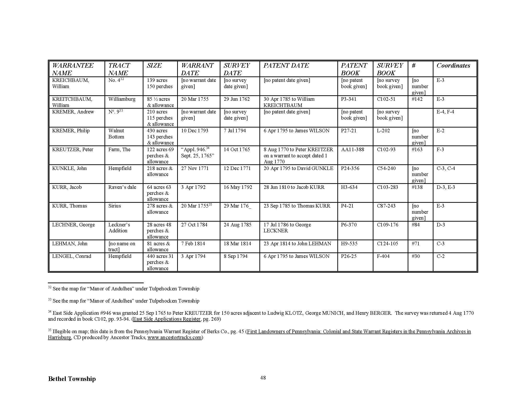
Following these maps are charts (see sample below) which include each fact included on every tract in the Township Warrantee Maps: names of the warrantee and patentee; size of the tract; name of the tract, if given; dates of the warrant, survey, and patent; Survey Book and page number where the survey was recorded; Patent Register and page number where the patent was recorded; and, finally, the coordinates where the tract in question is located. Numerous footnotes give further information, including neighbors shown on surveys at the time the survey was conducted. Some of these neighbors do not appear anywhere else in land records.
Please note that these land transfers predate the deed books located in each county because they deal with the first transfer of land to private individuals at the state level. Once the land passed into the hands of a private owner, any subsequent transfer of the land was recorded as deeds in the county courthouse as it existed at that time.
Before your buy our Atlas of Berks County tracts, see if the name(s) you are looking for appear in the 609-page Atlas Index. To see if they appear in individual township chapters (downloadable as pdf files), Index to Individual Township Chapters by SURNAME,” or to see the index by neighborhood, click on “Berks County Index by TOWNSHIP.”
The majority of the warrants were issued before the first U.S. census in 1790, but some of the land transactions occur as late as the 1920s.
No maps are included for the following townships: Colebrookdale, Douglass, Earl, Hereford, Ontelaunee, Perry, Pike, and Washington, We have added as much information as we could find for these townships from the East Side Applications Register (1765-1769) for these areas to document the first landowners, but these tracts are generally not located on the maps in this volume. Partial maps and maps with little detail (sometimes only a name and year) are given for the following townships in the atlas: Albany, District, Greenwich, Longswamp, Maidencreek, Windsor, and Richmond. Some of these names are not in the index.
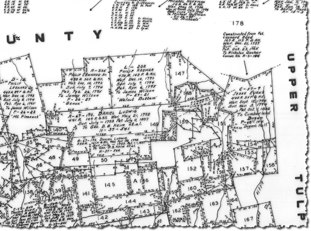
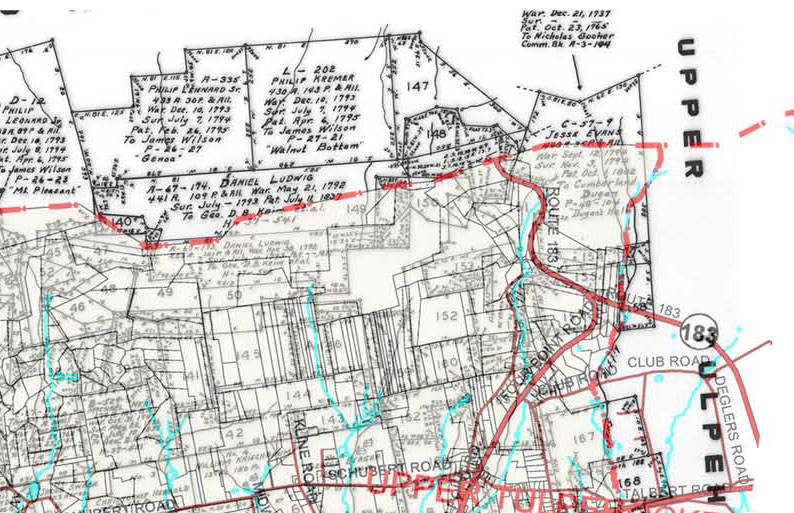
Samples from the Berks County Atlas: Below is a a part of an image of the Bethel Township Warrantee Map showing the type of information shown on each plat (see Philip Kremer’s tract at the top) and a the sample atlas page for this township showing the entry for Philip Kremer. The Township Warrantee Map superimposed by the Berks County GIS division onto modern road maps (included in this atlas) is on the right below.
You can order the entire atlas or each of the individual township chapters as follows:
Atlas of Township Warrantees of Berks County (607 pages, extensive intro, index; $45 pdf)
INDIVIDUAL TOWNSHIPS (with index; page numbers include intro)
Alsace Township (23 pages, 8 footnotes; $10.00)
Bern Township (35 pages, 17 footnotes; $14.00)
Bethel Twp w/Andulhea Manor (62 pages, 61 footnotes; $18.00)
Brecknock Township (41 pages, 27 footnotes; $14.00)
Caernarvon Township (29 pages, 17 footnotes; $12.00)
Centre Township (59 pages, 101 footnotes; $18.00)
Cumru Township (38 pages, 20 footnotes; $14.00)
Exeter Township (38 pages, 26 footnotes; $14.00)
Heidelberg Twp w/Plumpton Manor (30 pages; $12.00)
Jefferson Township (44 pages, 10 footnotes; $14.00)
Lower Heidelberg Township (31 pages, 5 footnotes; $12.00)
Marion w/Fells Manor (26 pages, 18 footnotes; $12.00)
Maxatawny & Rockland Twp (with part of Longswamp) (68 pages, 91 footnotes; $18.00)
Muhlenburg Township (21 pages, 2 footnotes; $10.00)
North Heidelberg Township (31 pages, 12 footnotes; $12.00)
Oley Township (44 pages, 40 footnotes; $14.00)
Penn Township (46 pages, 36 footnotes; $14.00)
Reading City & Borough (40 pages, 77 footnotes; $12.00)
Reading to Ruscombmanor Twp (45 pages, 51 footnotes; $14.00)
Robeson Township (54 pages, 29 footnotes; $16.00)
Rockland & Maxatawny Twp (see Maxatawny & Rockland Twp)
Ruscombmanor Twp (13 pages, substitute for missing PA Land Office Warrantee Map; $12)
South Heidelberg Township (30 pages, 7 footnotes; $12.00)
Spring Township (41 pages, 14 footnotes; $14.00)
Tilden Township (43 pages, 36 footnotes; $15.00)
Tulpehocken Township w/Andulhea (41 pages, 18 footnotes; $15.00)
Union Township (29 pages, 16 footnotes; $12.00)
Upper Bern Township (46 pages, 31 footnotes; $15.00)
Upper Tulpehocken Township (51 pages, 34 footnotes; $18.00)
19th-Century Residents
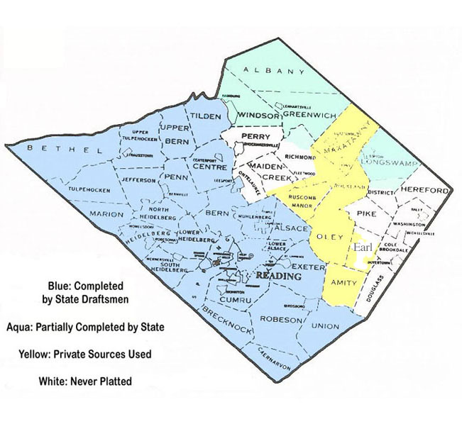
To see where the townships are in relation to each other, click here. Berks County was formed in 1752 from Chester, Lancaster, and Philadelphia Counties and contained Schuylkill County until 1811.
The 1876 Historical Atlas of Berks County has been posted online at The U.S. Genweb Archives site. Use this in conjunction with the 1870 and 1880 censuses, as well as published county histories.
Scroll below to see our free images from Map of Berks County from Actual Surveys published by H.S. Bridgens in 1860 which can be used in conjunction with the 1860, 1870, and 1880 census, as well as published county histories: Daniel Rupp’s 1844 History of the Counties of Berks and Lebanon; Morton Montgomery’s 1886 History of Berks County in Pennsylvania; Morton Montgomery’s 1909 Historical and Biographical Annals of Berks County, Pennsylvania (Volume I and Volume II); and Alvin Wagner’s 1913 The Story of Berks County, Pennsylvania.
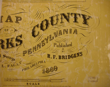
1860 Landowner Map
Click on the township of your choice below. Once the images are loaded, they can be enlarged by clicking on them. If an image doesn’t enlarge, right-click on it and choose “Open Image in New Tab.” When it is opened in a new tab, you will be able to zoom in.
While the map in the Library of Congress, is in the public domain the images we have taken belong to us and are not to be used for commercial use. For those wishing to use them for personal use (including illustrating a family history you are working on), we give permission to use them, but we would appreciate attribution to Ancestor Tracks. It takes much time and effort to locate, process, edit, and post these and the many other county images we have posted, so we appreciate this courtesy.
Townships
Albany Township
Alsace Township
Amity Township
Bern Township
Bethel Township
Brecknock Township
Caernarvon Township
Centre Township
Colebrookdale Township
Cumru Township
District Township
Douglass Township
Earl Township
Exeter Township
Greenwich Township
Heidelberg Township
Hereford Township
Jefferson Township
Longswamp Township
Lower Heidelberg Township
Maidencreek Township
Marion Township
Maxatawny Township
Muhlenberg Township
North Heidelberg Township
Oley Township
Ontelaunee Township
Penn Township
Perry Township
Pike Township
Richmond Township
Robeson Township
Rockland Township
Ruscombmanor Township
Spring Township
Tulpehocken Township
Union Township
Upper Tulpehocken Township
Upper Bern Township
Washington Township
Windsor Township
Towns and Villages
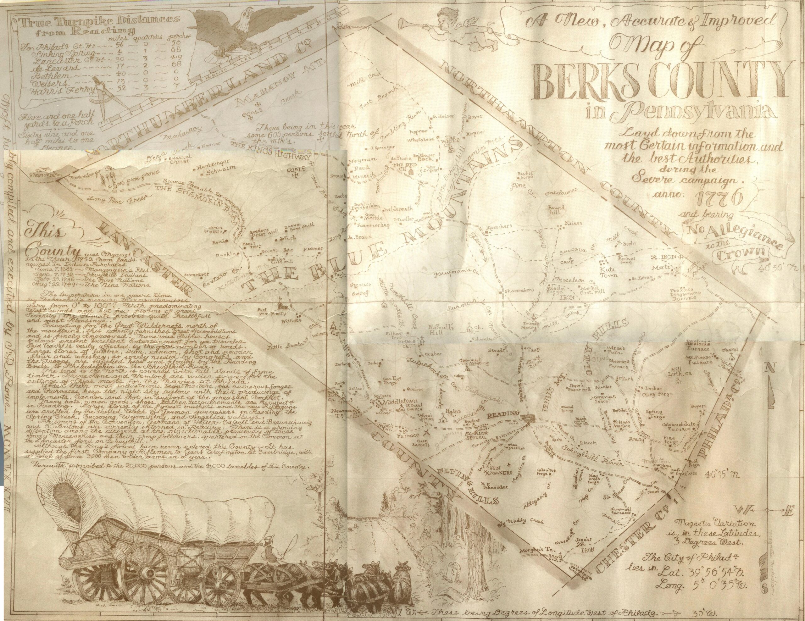
In addition to our Warrantee Atlas, there are several other maps showing the history and landowners of the county. The following is a map showing Berks Co. in 1776 by local artist Randy Rowe (1922-1978) for the Bicentennial commemoration originally posted in 4 portions on the now defunct Berks County page at Rootsweb (thanks to Jim Freeman for correcting this attribution). We have combined the 4 sections and are posting it with permission. Click on the small image below to see the details—it is a large map so it may take some time to load. It can be enlarged by right-clicking on the image an then choosing “Open Link in New Tab” from the drop-down menu, and then using the + sign to zoom in. It may also be saved to your computer by right-clicking and selecting “Save Image As…”