
Fayette County: Early Landowners of Fayette County
2020 Revision Published by Ancestor Tracks

Ancestor Tracks is committed to becoming a one-stop resource for researchers of early Pennsylvania landowners. In addition to publishing our own books, we are posting images of 19th century maps and atlases that we personally took in the Library of Congress. Our goal is to post landowner maps, or links to other websites with landowner maps, for every county in the state.
Original Land Owners
On this page, you will find links to the latest revision (2020) of our Fayette County atlas (first published in 2005) for sale, showing the metes-and-bounds tracts of the very first owners of land in Fayette County. Starting in 1907, the Pennsylvania Land Office began a project to research the original surveys and locate the original landowners and their tracts once and for all on maps of current townships. Over many years, each Township Warrantee Map was painstakingly platted by draftsmen from the original warrants, surveys, and patents. This atlas contains all of the Township Warrantee Maps drafted by the Pennsylvania Land Office in the early 1900s and information about each tract.
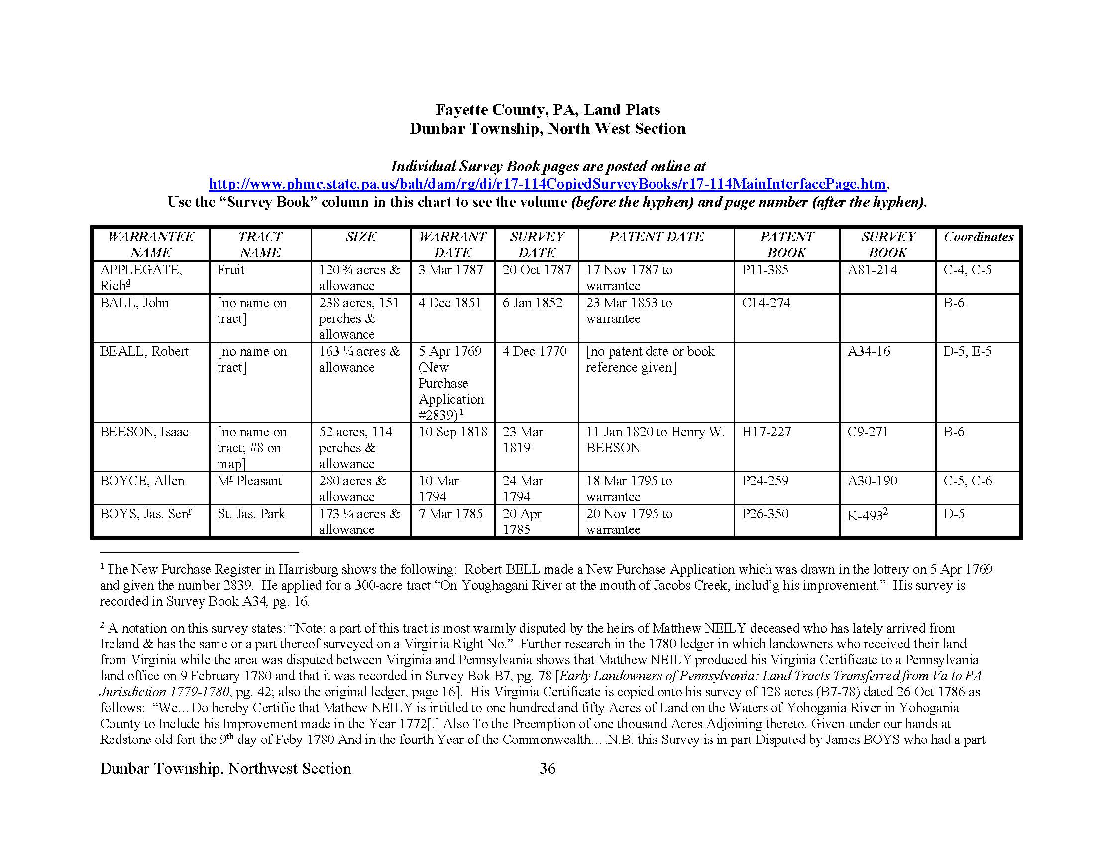
The maps show precise outlines of each original tract and all surrounding tracts in the township, giving the names of the warrantee and patentee; dates of the warrant, survey, and patent; and the patent book and page of the recorded patent. Fayette County was in the part of today’s Pennsylvania that was disputed with Virginia. To learn about the Pennsylvania Land Acquisition process that England set up to distribute colonial land (which basically continues today), as well as the boundary disputes (between Pennsylvania and Maryland, Pennsylvania and Virginia, and Pennsylvania and Connecticut), Revolutionary War Donation and Depreciation land, and land opened through treaties with Indians, see our Land Acquisition page.
The draftsmen, however, did not include the survey book and page number, so we recently added this information by looking up each tract in county Warrant Registers (the set of 67 county Warrant Registers plus 3 pre-1733 ledgers called First Landowners of PA: Colonial and State Warrant Registers in the PA Archives, Harrisburg, 1682-ca 1940 [$35] can now be downloaded and saved to your computer. Free images are also posted on the Pennsylvania State Archives website where each page of each county’s ledger is a separate pdf file).
We also added extensive footnotes giving further information, including neighbors shown on surveys at the time the survey was conducted. Some of these neighbors do not appear anywhere else in land records, and their appearance as a neighbor may be the only reference to their existence. We also added numerous reference notes from Fayette County history references and included an everyname index.
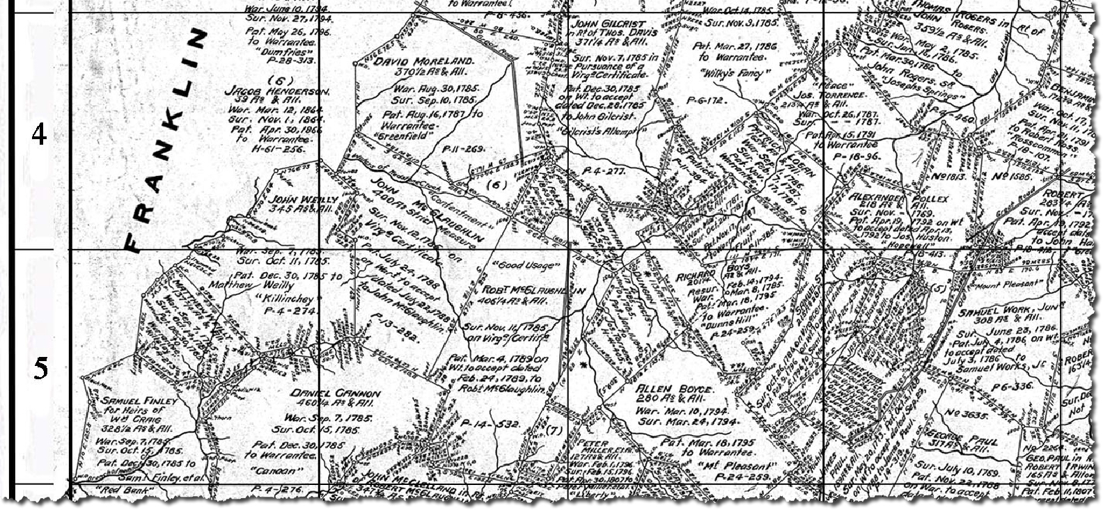
Each of the 26 chapters, one for each township, begins with the Township Warrantee Map. This is followed by the same map, cropped to eliminate marginal information and superimposed with an atlas coordinate grid. The maps are followed by charts containing all of the information we were able to find for each plat on the map.
Before your buy our Atlas of Fayette County, check the index of the 503-page atlas. To see if they appear in individual township chapters (downloadable as separate pdf files), click on Index to Individual Fayette Co. Township Chapters by NAME. To see the index by neighborhood, click on Index to Fayette County Chapters by TOWNSHIP.
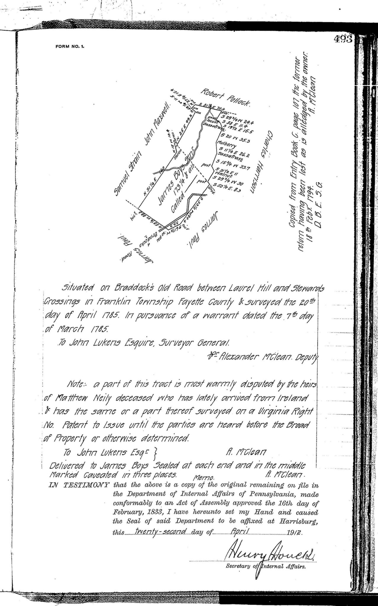
Nearly all of the individual loose surveys were gathered together and copied into ledgers early in the 20th century, and we are indeed fortunate that the Pennsylvania Archives, under the direction of Jonathan Stayer, has posted these “Copied Survey Books” online. To find the Survey Book and page number, consult the “Survey Book” column in this atlas (for example, the “Survey Book” entry for Jas. [James] Boys of Dunbar Township, Northwest section, on the page below, K-493, indicates the survey was recorded in Survey Book K, pg. 493, which can be seen using the “Copied Survey Books” link above). Also note the information about Matthew Neily who “lately arrived from Ireland” in the footnote. Using the same entry above for James Boys/Boyce, the chart shows his tract on the Northwest section of Dunbar Township map located at coordinates D-5 adjacent to Samuel Work Junr. (click on image for further information).
What became Fayette County was originally in Cumberland County (1750-1771), then Bedford County (1771-1773), then in Westmoreland County until Fayette became a county of its own in 1783.
Remember that once the land was transferred from the government to private individuals, all subsequent sales were recorded as deeds in the Fayette County Courthouse in Uniontown.
You can order the complete atlas or each of the individual township chapters below:
Atlas of Township Warrantees of Fayette County (503 pages containing all township chapters, extensive intro, footnotes, index, revised 2020; $40 pdf download)
Bullskin Township (35 pages, 32 footnotes; $14.00)
Connellsville Township (29 pages, 18 footnotes; $12.00)
Dunbar Township, Northwest Section (38 pages, 42 footnotes; $14.00)
Dunbar Township, Southeast Section (32 pages, 14 footnotes; $12.00)
Franklin Township (37 pages, 28 footnotes; $14.00)
Georges Township (49 pages, 61 footnotes; $16.00)
German Township (40 pages, 31 footnotes; $14.00)
Henry Clay Township (36 pages, 29 footnotes; $14.00)
Jefferson Township (33 pages, 32 footnotes; $14.00)
Lower Tyrone Township (29 pages, 28 footnotes; $12.00)
Luzerne Township (32 pages, 18 footnotes; $12.00)
Menallen Township (34 pages, 23 footnotes; $14.00)
Nicholson Township (31 pages, 30 footnotes; $14.00)
North Union Township (39 pages, 39 footnotes; $15.00)
Perry Township (34 pages, 34 footnotes; $14.00)
Redstone & Brownsville Township (40 pages, 37 footnotes; $14.00)
Saltlick Township (45 pages, 53 footnotes; $16.00)
South Union Township & Uniontown (38 pages, 27 footnotes; $14.00)
Springfield Township, Northern Section (29 pages, 21 footnotes; $12.00)
Springfield Township, Southern Section (30 pages, 11 footnotes; $12.00)
Springhill Township (39 pages, 31 footnotes; $14.00)
Stewart Township, N & E of the Yough (24 pages, 8 footnotes; $10.00)
Stewart Township, S & W of the Yough (26 pages, 10 footnotes; $10.00)
Upper Tyrone Township (24 pages, 19 footnotes; $12.00)
Washington Township (29 pages, 22 footnotes; $12.00)
Wharton Township, Northern Section (27 pages, 17 footnotes; $12.00)
Wharton Township, Southern Section (39 pages, 25 footnotes; $14.00)
19th-Century Residents
If your ancestors lived in Fayette County in the 19th century, see the excellent, zoomable 1858 “Map of Fayette County, Pennsylvania from Actual Surveys by McLaughlin & Kinter” published by Wm. J. Barker. Also check out the free 1872 Atlas of the County of Fayette and the State of Pennsylvania, by G.M. Hopkins & Co., Philadelphia, posted at the U.S. Genweb Archives. Use the maps in conjunction with Franklin Ellis’ 1882 History of Fayette County, Pennsylvania with Biographical Sketches as well as Henry Elliot Shepherd’s Nelson’s Biographical Dictionary and Historical Reference Book of Fayette County, Pennsylvania (Volume I and Volume II and Volume III).