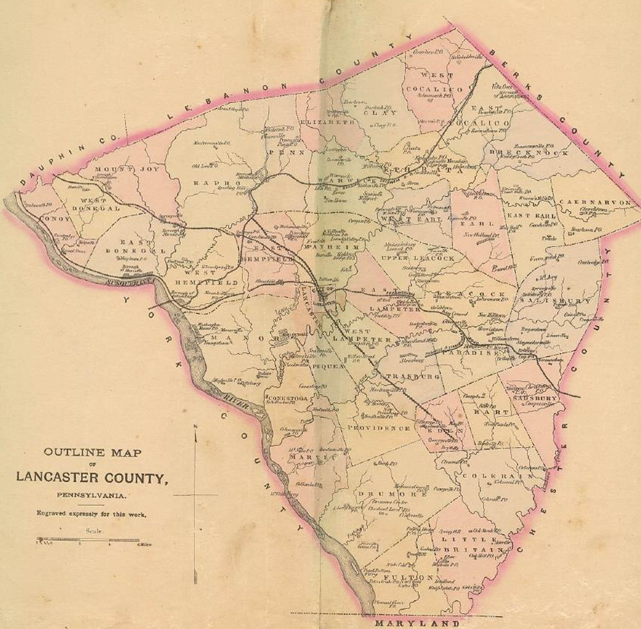
Ancestor Tracks is committed to becoming a one-stop resource for researchers of early Pennsylvania landowners. In addition to publishing our own books, we are posting images of 19th century maps and atlases that we personally took in the Library of Congress. Our goal is to post landowner maps, or links to other websites with landowner maps, for every county in the state.
Original Land Owners
This newly revised (2020) Lancaster County volume of county atlases in the “Early Landowners of PA” series contains all 41 of the Township Warrantee Maps which were produced by the Pennsylvania Land Office in the 1930s. Each Township Warrantee Map shows the location of the earliest landowners of each township of the county. The maps were painstakingly platted by draftsmen from the original warrants, surveys, and patents. They show precise outlines in metes and bounds of each original tract and all surrounding tracts in the township.
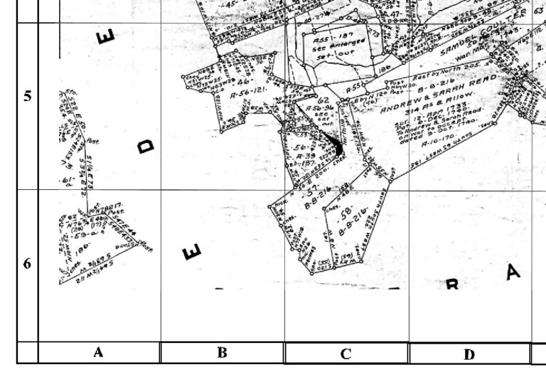
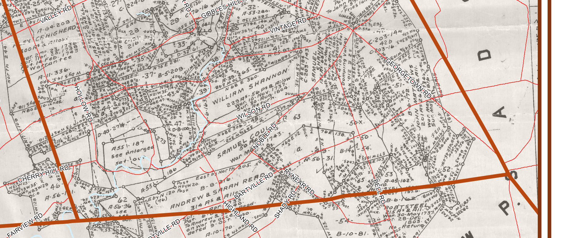
Each chapter begins with the Township Warrantee Map produced by the draftsmen (see sample below). A second map follows, cropped to eliminate marginal information, with atlas coordinates superimposed upon it. The third map, which was formerly only available on a companion CD at extra charge, consists of modern road maps superimposed on the warrantee map by the Lancaster County GIS Department. Consolidated information for each tract and landowner follows the maps.
Some of the draftsmen did not supply names of the warrantees and did not show them on the tract maps. Although we were unable to catch them all, we supplied hundreds of missing names of warrantees by consulting the copied surveys, the Lancaster County Warrant Register and others, and the relevant Patent Register any time one of two conditions was present: (1) there was a warrant to accept a previous survey; or (2) there was a large gap of time between the warrant and the patent, indicating that the land had probably changed hands.
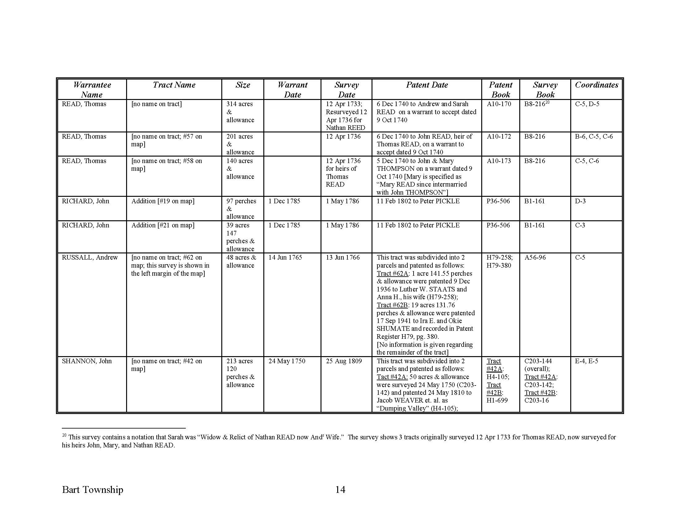
Following these maps are charts (see sample below) which include each fact included on every tract in the Township Warrantee Maps: names of the warrantee and patentee; size of the tract; name of the tract, if given; dates of the warrant, survey, and patent; Survey Book and page number where the survey was recorded; Patent Register and page number where the patent was recorded; and, finally, the coordinates where the tract in question is located. Numerous footnotes taken from surveys and county histories give further information, including neighbors shown on surveys at the time the survey was conducted. Some of these neighbors do not appear anywhere else in land records.
The warrantee maps show the location of the earliest landowners of the county—in other words, those who bought their land directly from the colony or state. See our explanation of how land was transferred from the government to individual owners from the earliest days of settlement. After a tract was transferred to a private individual, subsequent transactions were recorded as deeds in the county courthouse. Examining maps of these neighborhoods makes it possible to locate allied families, baptismal sponsors, neighbors, fellow church members, and migration companions.
If your ancestor was a neighbor to one of these tracts, you may find his or her name in the numerous footnotes included in this volume.
Before your buy our Atlas of Lancaster County, see if the name(s) you are looking for appear in the index of the 653-page Atlas. To see if they appear in individual township chapters (downloadable as separate pdf files), click on ” Index to Individual Township Chapters by SURNAME . To see the index by neighborhood, click on “Lancaster County Index by TOWNSHIP.” Nearly all of the individual loose surveys were gathered together and copied into ledgers early in the 20th century, and we are indeed fortunate that the Pennsylvania Archives, under the direction of Jonathan Stayer, has posted these “Copied Survey Books” online. To find the Survey Book and page number, consult the “Survey Book” column in this atlas
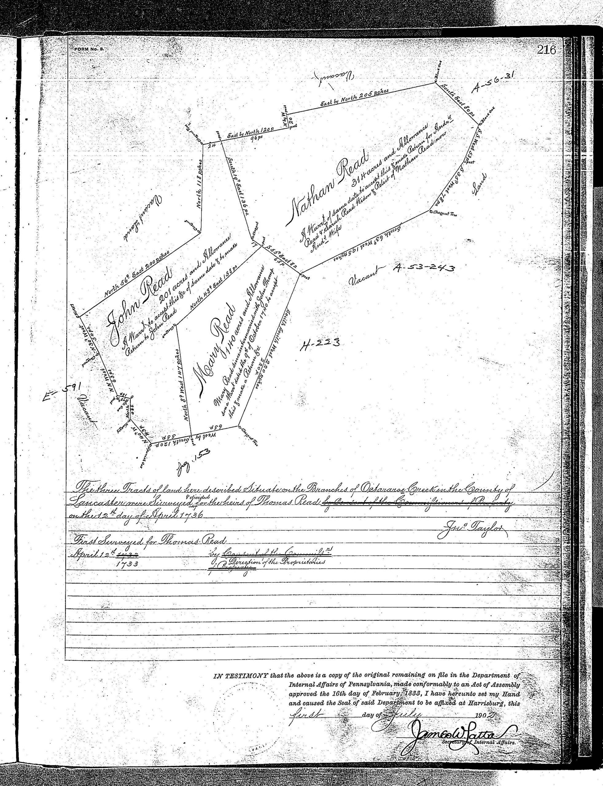
Example: Andrew and Sarah Read appear in the Bart Township chapter of this Lancaster Co. Atlas. Their entry in the book (below left) shows that a previous Read, Thomas Read, received a warrant on an unspecified date and the tract was surveyed in 1733 (Lancaster County was formed in 1733 from Philadelphia and Lancaster Counties, and that is when the Lancaster County Warrant Register was opened; to find the warrant for Thomas Read we would consult the pre-1733 “Old Rights Register” for parent counties Philadelphia and Lancaster). The 314-acre tract, which was not named, was resurveyed in 1736 for Nathan Reed and then patented (or given final title) to Andrew and Sarah Read on 6 Dec 1740. Their tract was recorded in Patent Register A10, pg. 170; the resurvey was recorded in Survey Book B8, pg. 216; and the tract can be found in atlas coordinates C-5, D-5.
The footnote contains information we transcribed from the online survey (next image) and shows that Sarah was the widow of Nathan Reid (who is undoubtedly the man who had the tract surveyed in 1736). Sarah remarried Andrew Read in 1740, indicating that Nathan died between those dates. It also shows that Andrew’s heirs were John, Mary, and Nathan Read. The survey also shows that Mary Read “since intermarried with John Thompson.” Reconstructing the family, we can hypothesize that Thomas was the father of Nathan and Andrew Read, both of whom married Sarah.
Click on each of the four images below in turn to see how the atlas works with online survey images: (1) the atlas page with consolidated information; (2) the atlas showing coordinates to help locate individual tracts; (3) the online survey in Survey Book B8, pg. 216; and (4) their tract superimposed on modern roads.