Ancestor Tracks is committed to becoming a one-stop resource for researchers of early Pennsylvania landowners. In addition to publishing our own books, we are posting images of 19th century maps and atlases that we personally took in the Library of Congress. Our goal is to post landowner maps, or links to other websites with landowner maps, for every county in the state.
Original Land Owners
The state of Pennsylvania began platting the exact metes-and-bounds tracts of the earliest landowners, township-by-township, starting in 1907, but the Land Office only completed about 1/3 of the state before the project ended. Unfortunately, Pennsylvania did not plat the tracts of the earliest landowners of Butler County.
The land within Butler County was part of the Purchase of 1784, or the “Last Purchase,” through which the Iroquois Confederacy gave up their claims through the Treaty of Fort Stanwix. Much of Butler County was set aside for Depreciation Land (see the explanation of, and links to, Depreciation Land and relevant records on our Land Acquisition page under “Revolutionary War and Donation and Depreciation Land”). In contrast to the process used previously, the Land Office surveyed rectangular or square tracts before it was offered for sale.
If your ancestor was actually a first landowner, purchasing his or her property from the colony or state of Pennsylvania, further information about these tracts may be gleaned from the Last Purchase Register and/or the Warrant and Patent Registers of Butler County and its parents: Westmoreland Co. (created in 1773) and Allegheny Co. (created in 1788 from Westmoreland and Washington) or Butler County (created in 1800 from Allegheny County). Many settlers arrived in this area before 1802 when Butler County was formed and its Warrant Register set up, so all of these county registers, or ledgers, should be checked for land transactions. See our explanation of how land was transferred from the government to individual owners from the earliest days of settlement.
The only way to find the date, book and page of the original warrant, survey, and patent for your ancestor is to search through the Warrant Registers on the Pennsylvania State Archives website where each page of each county’s ledger is a separate pdf file, or download and save to your computer the entire set of 67 county Warrant Registers plus 3 pre-1733 ledgers called First Landowners of PA: Colonial and State Warrant Registers in the PA Archives, Harrisburg, 1682-ca 1940 ($35). Once you have found the information, you can access the free online surveys, and you can order copies of the original documents from the Pennsylvania State Archives in Harrisburg using their order form.
If you cannot find an original landowner’s name in the Warrant Registers, the next place to look is in Pennsylvania’s index to Patent Registers ($35). Within an index covering the relevant years, the names are grouped alphabetically by the first letter of the patentee’s surname, then grouped by volume number of Patent Book, and finally arranged chronologically by date of patent. Thus, you have to look through the entire alphabetical section (which may be as little as one page to as many as 50) to be sure you don’t miss anyone.
19th-Century Residents
Be sure to go to the excellent site at the USGenWeb Project for Butler County. This is a quality site which has also posted images from the 1858 map which we are posting alternate images of below, as well as the Atlas of 1874. Also see their “Land Warrants & Patents” page for Warrants prior to 1802, and their wonderful transcriptions of both the 1883 History of Butler County Pennsylvania and the 1895 History of Butler Co.,PA. Kudos to the many volunteers who participated in these tasks!
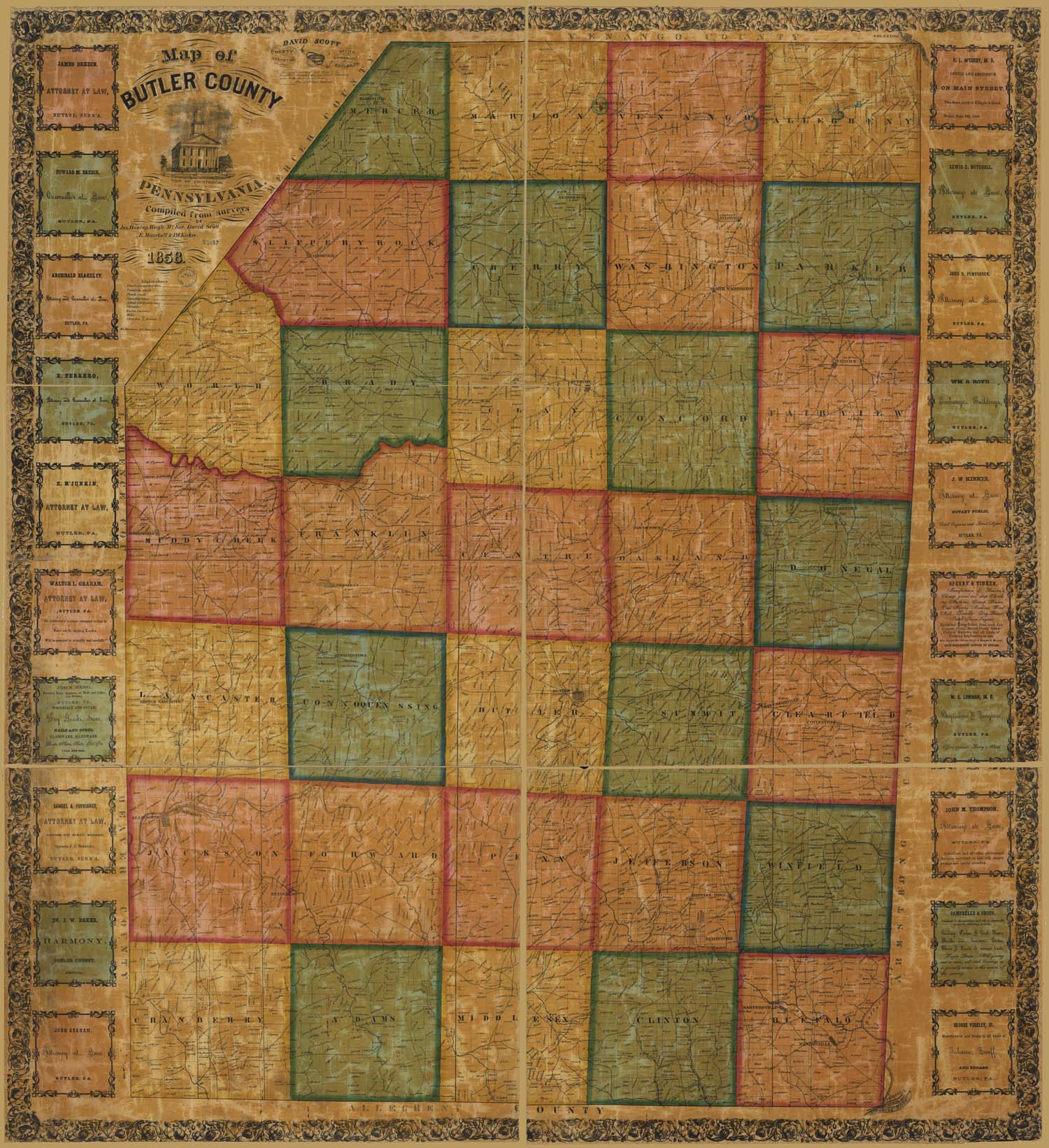
In lieu of being able to bring you Township Warrantee Maps of the earliest settlers, we are posting the Map of Butler Co., Pennsylvania from surveys by Jas. Dunlap, Hugh McKee, David Scott, E. Maurhoff & J.W. Kirker which was published in 1858. This map is located in the Library of Congress Geography and Map Division Washington, D.C. We hope that it will be a useful tool for locating your Butler County families when coupled with the 1850, 1860, 1870, and 1880 censuses and published county histories: the 1883 History of Butler County, Pennsylvania; R.C. Brown’s 1895 History of Butler County, Pennsylvania; James McKee’s 1909 20th Century History of Butler and Butler County, Pa., and Representative Citizens; and McKnight’s 1905 A Pioneer Outline History of Northwestern Pennsylvania, Embracing the Counties of Tioga, Potter, McKean, Warren, Crawford, Venango, Forest, Clarion, Elk, Jefferson, Cameron, Butler, Lawrence, and Mercer.