
Chester County Land Resources
Ancestor Tracks is committed to becoming a one-stop resource for researchers of early Pennsylvania landowners. In addition to publishing our own books, we are posting images of 19th century maps and atlases that we personally took in the Library of Congress. Our goal is to post landowner maps, or links to other websites with landowner maps, for every county in the state.
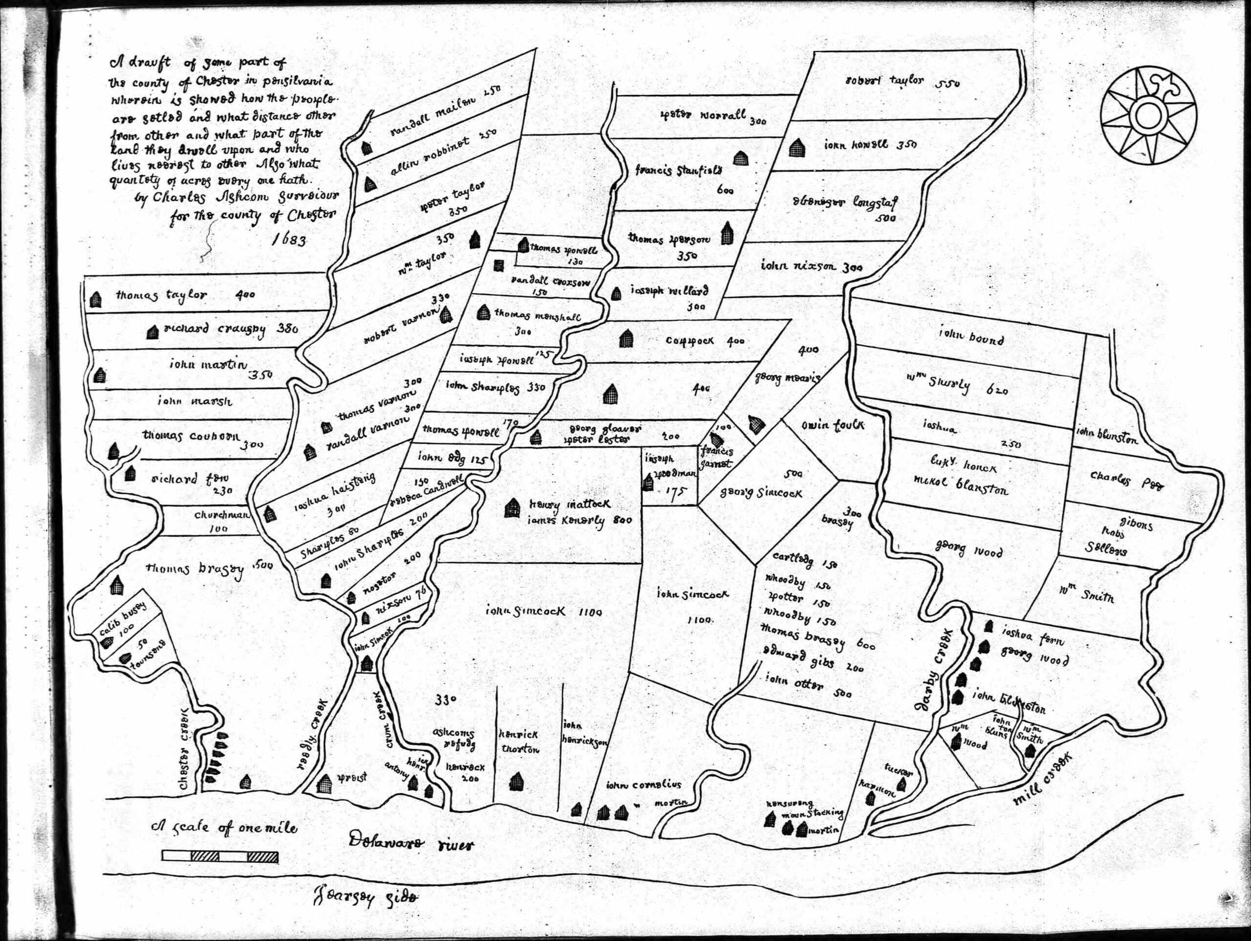
Original Land Owners: Unfortunately, the state of Pennsylvania did not plat the original warrantees and patentees on township maps, so there will be no volume regarding Chester Co. joining the Early Landowner series. However, a 1683 map of landowners was published in Henry Ashmead’s Historical Sketch of Chester, On Delaware with Maps and Illustrations (Chester, PA: Republican Steam Printing House, 1883).
See our explanation of how land was transferred from the government to individual owners from the earliest days of settlement.
The only way to find the date, book and page of the original warrant, survey, and patent for your ancestor is to do what the state draftsmen did to create their warrantee maps of other counties. They searched through the relevant county Warrant Register, and that of its parent counties, now posted on the Pennsylvania State Archives website where each page of each county’s ledger is a separate pdf file, or download and save to your computer the entire set of 67 county Warrant Registers plus 3 pre-1733 ledgers called First Landowners of PA: Colonial and State Warrant Registers in the PA Archives, Harrisburg, 1682-ca 1940 ($35). Once you have found the information, you can access the free online surveys, and you can order copies of the original documents from the Pennsylvania State Archives in Harrisburg using their order form.
If you cannot find an original landowner’s name in the Warrant Registers, the next place to look is in Pennsylvania’s index to Patent Registers ($35). Within an index covering the relevant years, the names are grouped alphabetically by the first letter of the patentee’s surname, then grouped by volume number of Patent Book, and finally arranged chronologically by date of patent. Thus, you have to look through the entire alphabetical section (which may be as little as one page to as many as 50) to be sure you don’t miss anyone. See our explanation of how land was transferred from the government to individual owners from the earliest days of settlement.
Please note that these land transfers predate the deed books located in each county because they deal with the first transfer of land to private individuals at the state level. Once the land passed into the hands of a private owner, any subsequent transfer of the land was recorded as deeds in the county courthouse as it existed at that time.
Also, Estelle Cremers has created connected draft maps of the original owners of land in several townships in northern Chester County:
- East Coventry
- North Coventry
- South Coventry
- East Pikeland
- West Pikeland
- East Vincent
- West Vincent
- Warwick
- Upper Uwchlan
She also published five books:
- 30,000 Acres, History of the Vincents and the Pikelands
- Reading Furnace, 1736
- Treasures of the Upper French Creek, Warwick Township
- Coventry the Skool Kill District, Basic History of the Three Coventry Townships, 1700-1850
- The Upper Uwchlan, A Place Betwixt and Between
Check the Chester County History Center, the Tri-County Heritage Library which is now part of the Hay Creek Valley
Historical Association, and the unparalleled Chester County Archives & Records Services for copies. These maps show the tracts according to metes and bounds and include the survey numbers so that the original surveys can be obtained from the Pennsylvania Archives in Harrisburg.
Be sure to check the resources at the Chester County Genealogy Project for maps, names of warrantees, tax lists, military records, and a plethora of other topics.
Revolutionary War Residents: The Chester County Archives has produced a prize-winning interactive map showing residents in 1777, British depredations reported by property owners, locations of churches and meetinghouses, etc.
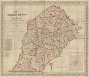
19th-Century Residents: In lieu of being able to produce a book of the earliest landowners, we are posting images from Breou’s Official Series of Farm Maps, Chester County published by W.H. Kirk, 1883, courtesy of Nancy Romig of the Western Pennsylvania Genealogical Society. This atlas should be an invaluable tool when used in conjunction with the 1870 and 1880 census and with the several published histories of Chester County: Futhey and Cope’s 1881 1881 History of Chester County, Pennsylvania, with Genealogical and Biographical Sketches; Samuel Wiley’s 1893 Biographical and Portrait Cyclopedia of Chester County, Pennsylvania: Comprising a Historical Sketch of the County; Thomson’s 1898 Chester County and Its People; and Charles William Heathcote’s 1932 History of Chester County, Pennsylvania.
Click on the township of your choice below. Once the images are loaded, they can be enlarged by clicking on them. If an image doesn’t enlarge, right-click on it and choose “Open Image in New Tab.” When it is opened in a new tab, you will be able to zoom in.

Breou’s Official Series of Farm Maps, Chester County, Pennsylvania, 1883
Township Maps
Birmingham Township
Caln Township
Charleston Township
East Bradford Township
East Brandywine Township
East Caln Township
East Coventry Township
East Fallowfield Township
East Goshen Township
East Marlborough Township
East Nantmeal Township
East Nottingham Township
East Pikeland Township
East Vincent Township
East Whiteland Township
Easttown Township
Elk Township
Franklin Township
Highland Township
Honey Brook Township
London Britain Township
Longon Grove Township
Londonderry Township
Lower Oxford Township
New Garden Township
New London Township
Newlin Township
North Coventry Township
Penn Township
Pennsbury Township
Pocopson Township
Sadsbury Township
Schuylkill Township
South Coventry Township
Thornbury Township
Tredyffrin Township
Upper Oxford Township
Upper Uwchlan Township
Uwchlan Township
Valley Township
Wallace Township
Warwick Township
West Bradford Township
West Brandywine Township
West Caln Township
West Fallowfield Township
West Goshen Township
West Marlborough Township
West Nantmeal Township
West Nottingham Township
West Pikeland Township
West Sadsbury Township
West Vincent Township
West Whiteland Township
Westtown Township
Willistown Township
Towns and Villages
Atglen Borough
Avondale Borough
Birchrunville
Boxtown
Byers Station
Cedarville/Pottstown Landing
Charlestown
Chatham
Coatsville, Part 1
Coatsville, Part 2
Cochranville
Compassville
Downingtown Borough, Part 1
Downingtown Borough, Part 2
Downingtown Borough, Part 3
Fairville
GlenMore
Goshenville
Guthrieville
Hamorton
Harmonyville
Homeville
Hopewell
Jennerville
Kemblesville
Kennett Square Borough
Kimberton
Knauertown
Lincoln
Lionville
Malvern Borough
Marshalton
Oxford Borough
Parkersville
Parkesburg Borough
Pennsbury
Phoenixville Borough, Part 1
Phoenixville Borough, Part 2
Phoenixville Borough, Part 3
Pomeroy
Rock Run
Romansville
Russellville
Sadsburyville
Spring City Borough
Springfield
St. Mary’s
Sugartown
Toughkenamon
Unionville
Valley Forge
Waynesburg
West Chester Borough, East Ward
West Chester Borough, North Ward
West Chester Borough, South Ward
West Chester Borough, West Ward
West Grove Borough
Windsor