
Cumberland County Landowners
Warrantee Maps by Eschenmann and Barner
and
1872 Atlas of Cumberland Co. by Beers (scroll down)
Our goal at Ancestor Tracks is to publish maps and land ownership information allowing genealogy researchers to place more precisely the locations where our ancestors lived.
Original Land Owners
The state of Pennsylvania began platting the exact metes-and-bounds tracts of the earliest landowners, township-by-township, starting in 1907, but the Land Office only completed about 1/3 of the state before the project ended. Unfortunately, Pennsylvania only platted one township within Cumberland County, East Pennsboro Township.
Researchers are indeed fortunate, however, that Hayes R. Eschenmann began to systematically research and map the tracts of the earliest landowners of the county, aligning their surveys with USGS topographic quadrangle maps. He published volumes for four quadrangles before his passing, and his project was taken up by his editor, Paul Barner, who completed the additional volumes. See our explanation of how land was transferred from the government to individual owners from the earliest days of settlement.
The Eschenmann and Barner pamphlets will probably give you enough data to access copies of the warrant, original survey, and patent in the Pennsylvania State Archives, but if you need to find the date, book and page of the original warrant, survey, and patent for your ancestor, you will need to search through the Cumberland County Warrant Register on the Pennsylvania State Archives website where each page of each county’s ledger is a separate pdf file, or download and save to your computer the entire set of 67 county Warrant Registers plus 3 pre-1733 ledgers called First Landowners of PA: Colonial and State Warrant Registers in the PA Archives, Harrisburg, 1682-ca 1940 ($35). Once you have found the information, you can access the free online surveys, and you can order copies of the original documents from the Pennsylvania State Archives in Harrisburg using their order form. Please note that these land transfers predate the deed books located in each county because they deal with the first transfer of land to private individuals at the state level.
If you cannot find an original landowner’s name in the Warrant Registers, the next place to look is in Pennsylvania’s index to Patent Registers ($35). Within an index covering the relevant years, the names are grouped alphabetically by the first letter of the patentee’s surname, then grouped by volume number of Patent Book, and finally arranged chronologically by date of patent. Thus, you have to look through the entire alphabetical section (which may be as little as one page to as many as 50) to be sure you don’t miss anyone.
47 volumes of First Families of Cumberland County have been published, each of which includes a 22″ X 30″ map showing the tracts, and they may be ordered for $18 each plus shipping and handling. The index to the volumes is available on this site, as well as a key to the Quadrangle abbreviations. The volumes available at Cumberland County Historical Society are:
Volume I: Shippensburg Quadrangle; land in Cumberland and Franklin Counties.
Volume 2: Newburg Quadrangle; land in Cumberland, Perry, and Franklin Counties
Volume 3: Newville Quadrangle; Cumberland County
Volume 4: Walnut Bottom Quadrangle; Cumberland County
Volume 5: Plainfield Quandrangle; Cumberland County
Volume 6: Andersonburg Quadrangle (Doubling Gap) & Landisburg Quadrangle (McClure’s Gap); Cumberland County
Volume 7: Dickinson Quadrangle; Cumberland and Adams County
Volume 8: Caledonia Park Quadrangle; land in Cumberland, Franklin and Adams Counties
Volume 9: Scotland Quadrangle; Franklin County
Volume 10: Chambersburg Quadrangle; Franklin County
Volume 11: Roxbury Quadrangle; Franklin County
Volume 12: Carlisle Quadrangle; Cumberland County
Volume 13: Waynesboro and Southern Washington Twp.; Franklin County
Volume 14: Shermans Dale and Wertzville Quadrangles; Cumberland and Perry Counties
Volume 15 : Greencastle and Stateline; Franklin County
Volume 16: Mount Holly Springs Quadrangle; land in Cumberland, Adams, and York Counties
Volume 17: South Mountain (Iron Springs Quadrangle) and Blue Ridge Summit Quadrangle; Franklin County
Volume 18: Mechanicsburg Quadrangle and White Rocks (Dillsburg); land in Cumberland and York Counties
Volume 19: Williamson and Mason-Dixon Quadrangles; Franklin County
Volume 20: The West Shore (Harrisburg West, Lemoyne, Steelton); Cumberland County
Volume 21: Saint Thomas Quadrangle; Franklin County
Volume 22: Mercersburg Quadrangle & Kasiesville (Clear Spring Quadrangle); Franklin County
Volume 23: Little Cove & Big Cove Tannery Quadrangle; land in Franklin and Fulton Counties
Volume 24: Fort Loudon & McConnellsburg Quadrangle; Franklin County
Volume 25: Fannettsburg Quadrangle; Franklin and Huntingdon Counties
Volume 26: Burnt Cabins Quadrangle; Franklin, Fulton and Huntingdon Counties
Volume 27: Meadow Grounds Quadrangle; Fulton County
Volume 28: Doylesburg Quadrangle; Franklin County
Volume 29: Shade Gap Quadrangle; Huntingdon and Franklin Counties
Volume 30: Blairs Mills Quadrangle; Hungtondon, Franklin, Juniata, and Perry Counties
Volume 31: Aughwick Quadrangle; Huntingdon and Mifflin Counties
Volume 32: Needmore Quadrangle; Fulton County
Volume 33: McCoysville Quadrangle; Juniata County
Volume 34: Orbisonia Quadrangle; Huntingdon County
Volume 35: Hustontown Quadrangle; Fulton and Huntingdon Counties
Volume 36: Breezewood Quadrangle; Fulton and Bedford Counties
Volume 37: Mifflintown and Spruce Hill Quadrangles; Juniata and Mifflin Counties
Volume 38: Wells Tannery; Fulton and Bedford Counties
Volume 39: Everett East Quadrangle; Bedford County
Volume 40: Mench Quadrangle; Bedford and Fulton Counties
Volume 41: Saltillo Quadrangle, Huntingdon and Fulton Counties
Volume 42: Butler Knob Quadrangle; Huntingdon County
Volume 43: McVeytown Quadrangle; Mifflin and Juniata Counties
Volume 44: Lewiston Quadrangle; Mifflin and Juniata Counties
Volume 45: Amaranth and Bellegrove Quadrangles; Fulton and Bedford Counties
Volume 46: Xaston Quadrangle; Bedford, Huntingdon and Fulton Counties
Volume 47: Cassville Quadrangle; Huntingdon County
19th-Century Residents
An excellent 1858 Map of Cumberland County, Pennsylvania: from Actual Surveys published by H. F. Bridgens is posted through the Leventhal Map Collection at Boston Public Library. To see residents before the Civil War, click on it and zoom in with your cursor’s wheel to see names and locations.
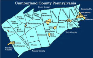
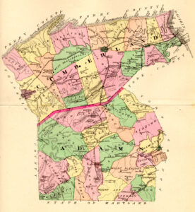 Cumberland County Atlas with Landowners, 1872
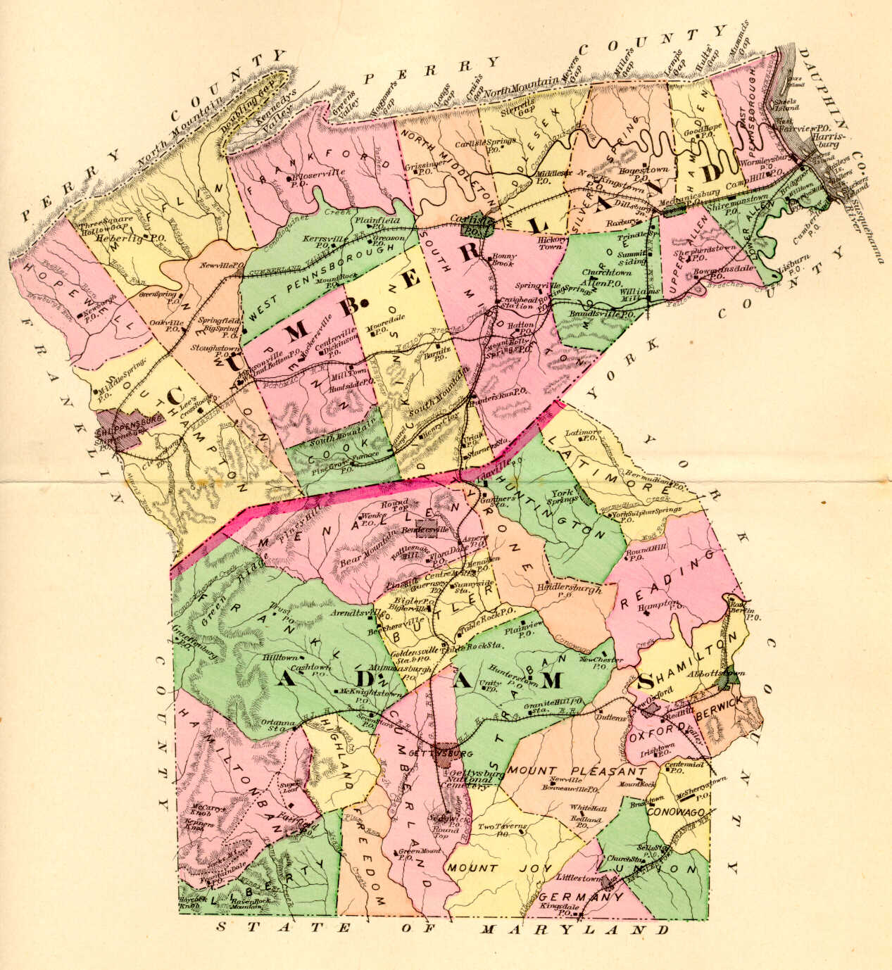
Click on the township of your choice below. Once the images are loaded, they can be enlarged by clicking on them. If an image doesn’t enlarge, right-click on it and choose “Open Image in New Tab.” When it is opened in a new tab, you will be able to zoom in. You can also save the images.
While the map in the Library of Congress, is in the public domain the images we have taken belong to us and are not to be used for commercial use. For those wishing to use them for personal use (including illustrating a family history you are working on), we give permission to use them, but we would appreciate attribution to Ancestor Tracks. It takes much time and effort to locate, process, edit, and post these and the many other county images we have posted, so we appreciate this courtesy.
Township Maps
East Pennsborough Township
Frankford Township
Hampden Township
Hopewell Township
Lower Allen Township
Middlesex Township
Mifflin Township
Monroe Township
Newton Township
North Middleton Township
Penn Township
Silver Spring Township
Southampton Township and Shippensburg
South Middleton Township
Upper Allen Township
West Pennsborough Township
Boroughs, Towns and Villages
Bloserville
Boiling Springs
Brush Town
Camp Hill
Carlisle
Carlisle, East Ward (part)
Carlisle, East Ward (part)
Carlisle, West Ward
Centreville
Churchtown
Cleversburg
Craighead Station
Cummins
Greason
Hickory Town
Hockersville
Hogestown
Jacksonville
Laurel Forge
Leesburg
Lisburn
Middle Spring
Milltown (Eberlys Mills)
Mill Town (Penn Twp.)
Mount Holly
Mount Holly Springs
Mount Rock
New Cumberland
New Kingston
New Lancaster
Newberg
Newtown
Newville
Oakville
Pine Grove
Plainfield
Shepherdstown
Shippensburg
Shirmanstown
Springfield
Springville
Stoughstown
West Fairview
West Hill
Wormleysburg
Use the 1872 atlas in conjunction with the excellent 1886 History of Cumberland and Adams County, Pennsylvania which is online courtesy of the Internet Archive. Also check out Rupp’s 1846 History and Topography of Dauphin, Cumberland, Franklin, Bedford, Adams, and Perry Counties.