
Lackawanna County - Early Landowners
Ancestor Tracks is committed to becoming a one-stop resource for researchers of early Pennsylvania landowners. In addition to publishing our own books, we are posting images of 19th century maps and atlases that we personally took in the Library of Congress. Our goal is to post landowner maps, or links to other websites with landowner maps, for every county in the state.
Original Land Owners
The state of Pennsylvania began platting the exact metes-and-bounds tracts of the earliest landowners, township-by-township, starting in 1907, and they did complete connected tract maps of the earliest landowners of Lackawanna County (which was created from Luzerne Co. in 1878). We hope to transcribe them at some time to make the significant information on them available to researchers. In the meantime, the unindexed maps are online, courtesy of the Pennsylvania Archives, and we are posting links to them (scroll below for the 1873 atlas links).
See our explanation of how land was transferred from the government to individual owners from the earliest days of settlement.
The draftsmen at the Pennsylvania Land Office used the Warrant and Patent Registers to create the Warrantee Maps. They searched for him or her in the correct alphabetical section and then chronologically through county Warrant Registers on the Pennsylvania State Archives website where each page of each county’s ledger is a separate pdf file, or download and save to your computer the entire set of 67 county Warrant Registers plus 3 pre-1733 ledgers called First Landowners of PA: Colonial and State Warrant Registers in the PA Archives, Harrisburg, 1682-ca 1940 ($35). The Pennsylvania State Archives has posted the free online surveys (check both front and back sides) and you can order copies of the original documents from the Pennsylvania State Archives in Harrisburg using their order form. Remember that Luzerne County was created from Northumberland County in 1786 (and Lackawanna County was carved from Luzerne County in 1878), but many of the earliest landowners purchased before Luzerne was created, so you may have to search in those three counties for warrants, wills, court records, etc., depending on when your ancestor settled in the region. Once the land passed into the hands of a private owner, any subsequent transfer of the land was recorded in the county courthouse as it existed at that time.
They also searched Pennsylvania’s index to Patent Registers ($35). Within an index covering the relevant years, the names are grouped alphabetically by the first letter of the patentee’s surname, then grouped by volume number of Patent Book, and finally arranged chronologically by date of patent. Thus, you have to look through the entire alphabetical section (which may be as little as one page to as many as 50) to be sure you don’t miss anyone.
Keep in mind that Lackawanna County as part of Luzerne County was created from the original vast Northumberland County in 1786. The entire area was known as the Wyoming Valley which you can read about in the 1909 A History of Wilkes-Barre, Luzerne County, Pennsylvania: from its first beginnings to the present time, including chapters of newly-discovered early Wyoming Valley history…. Also see the 1845 “History of Wyoming, in a Series of Letters from Charles Miner to his son William Penn Miner, Esq.”
Until a compromise was worked out in 1782 under the Articles of Confederation, the entire northern 1/3 of Pennsylvania was claimed by both Connecticut and Pennsylvania because King Charles II of England had inadvertently granted the land to both colonies. A series of skirmishes called the Pennamite-Yankee Wars broke out, costing bloodshed on both sides before and during the Revolutionary War. The huge area of Pennsylvania’s Luzerne County was eventually cut up into several counties: Bradford, which was originally called Ontario County, was created from parts of Luzerne and Lycoming Counties in 1810; Lackawanna was carved from Luzerne in 1878; Susquehanna County in 1810; and Wyoming County in 1842. See our explanation of how land was transferred from the government to individual owners from the earliest days of settlement.
19th-Century Residents
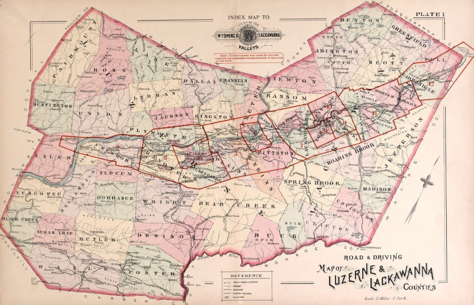
We are posting free, downloadable images from the 1873 Atlas of Luzerne County, Pennsylvania, from actual surveys by and under the direction of D. G. Beers published by A. Pomeroy & Co. This atlas, of course, includes Lackawanna County. We hope these images will be useful for pinpointing the whereabouts of residents in the 1850-1880 census records and those mentioned in the 1893 History of Luzerne County, Pennsylvania by Henry C. Bradsby and in History of the Lackawanna Valley by Horace Hollister.
The 1873 atlas also includes images of simplified Warrantee Maps of Luzerne and Lackawanna Counties, but more information regarding each tract can be found in the Township Warrantee Maps posted by the Pennsylvania Archives (see links below the atlas).
Luzerne County, 1873 (while Lackawanna was part of Luzerne)
Click on the title page to see the arrangement of townships
Atlas,1873/Luzerne%20Co.%20Townships.jpg)
Click on the township of your choice below. Once the images are loaded, they can be enlarged by clicking on them. If an image doesn’t enlarge, right-click on it and choose “Open Image in New Tab.” When it is opened in a new tab, you will be able to zoom in. You can also save the images.
While the map in the Library of Congress, is in the public domain the images we have taken belong to us and are not to be used for commercial use. For those wishing to use them for personal use (including illustrating a family history you are working on), we give permission to use them, but we would appreciate attribution to Ancestor Tracks. It takes much time and effort to locate, process, edit, and post these and the many other county images we have posted, so we appreciate this courtesy.
1873 Township Residents
Towns and Boroughs
Warrantee Maps (First Landowners) in Atlas
Clifton Township (created from Covington Twp. in 1873) |
Elmhurst Township (formed in 1941) |
Glenburn Township (created in 1877) |
La Plume Township (a borough in 1885, but lost status) |
Lehigh Township (called Bucks Twp. until 1880 |
Providence Township (consolidated into Scranton, 1866) |
Roaring Brook Township (created 1871) |
Thornhurst Township (created from Buck Twp., Luzerne County, 1878) |
Waverly Township (formerly Abington Township) |
West Abington Township (created from Abington Township in 1895) |
Atlas,1873/RoaringBrookTp-Lack,Dunnings.jpg)
Links to Warrantee Maps in the Pennsylvania State Archives
If your ancestors were one of the first landowners in the county, purchasing their land directly from the colony or state of Pennsylvania, he or she should be shown on the following warrantee maps. The following Township Warrantee Maps, showing the metes-and-bounds plats of the first landowners of the county, have been placed online by the Pennsylvania Archives in Harrisburg (the maps below are large and may take time to completely download). Information on each tract (or in the margin of the map) includes a hyphenated entry such as A-19-121. This refers to the the Survey Book (A19) and page number (121) where the survey was recorded in Harrisburg. The other information includes the size of the tract; the warrant, survey and patent date; name of the patentee; and Patent Book and page number where the patent is recorded.
These land transfers predate the deed books located in each county because they deal with the first transfer of land to private individuals from Pennsylvania’s colonial or state government. Once the land passed into the hands of a private owner, any subsequent transfer of the land was recorded as deeds in the county courthouse as it existed at that time.
Lackawanna County Township Warrantee Maps in the
Pennsylvania State Archives
Laplume (La Plume Township) |
A zoomable 1864 Map of the County of Luzerne, Pennsylvania (while Lackawanna was still part of Luzerne) is posted by the Library of Congress. Black-and-white images of the 1873 atlas with more detail for towns and villages are posted at the U.S. Genweb Archives. Also, a separate 1894 Atlas of the Wyoming and Lackawanna Valleys and Map of Luzerne and Lackawanna Counties, Penna. by G. W. Baist is on the Library of Congress website.
Also see the 1877 Atlas of the City of Scranton scanned and posted by Susan White Pieroth and the excellent Lackawanna County PAGenWeb site.