Ancestor Tracks is committed to becoming a one-stop resource for researchers of early Pennsylvania landowners. In addition to publishing our own books, we are posting images of 19th century maps and atlases that we personally took in the Library of Congress. Our goal is to post landowner maps, or links to other websites with landowner maps, for every county in the state.
Original Land Owners
The state of Pennsylvania began platting the exact metes-and-bounds tracts of the earliest landowners, township-by-township, starting in 1907, but the Land Office only completed about 1/3 of the state before the project ended.
To learn about the Pennsylvania Land Acquisition process that England set up to distribute colonial land (which basically continues today), as well as the boundary disputes (between Pennsylvania and Maryland, Pennsylvania and Virginia, and Pennsylvania and Connecticut), Revolutionary War Donation and Depreciation land, and land opened through treaties with Indians, see our Land Acquisition page.
Unfortunately, Pennsylvania did not plat the tracts of the earliest landowners of Northampton County. We are incredibly fortunate, however, that James B. Wolfson of Fresno, CA, spent a number of years documenting the warrantees and patentees of the townships of Lebanon County. He published his research in a series of excellent short booklets, one for each township, which the serious researcher of early landowners of the area simply must not ignore. Each of his booklets includes a map drawn by Mr. Wolfson showing the original tracts, as well as charts documenting the warrantee and patentee of each tract; the size and name of the tract; the warrant, survey and patent dates; and the survey book and page number where the surveys are recorded.
Mr. Wolfson used the Warrant and Patent Registers to create the Warrantee Maps. He searched each county and parent county, then each alphabetical section chronologically, in the set of 67 county Warrant Registers plus 3 pre-1733 ledgers called First Landowners of PA: Colonial and State Warrant Registers in the PA Archives, Harrisburg, 1682-ca 1940 ($35) which can now be downloaded and saved to your computer. (Free images are also posted on the Pennsylvania State Archives website where each page of each county’s ledger is a separate pdf file). The Warrant Registers state the Survey Book and page number onto which the loose survey was copied. The Pennsylvania State Archives has posted the online survey books (both front and back side of each survey have been digitized). Using the information from the Warrant Registers, you can order copies of the original documents from the Pennsylvania State Archives in Harrisburg using their order form.
Mr. Wolfson also searched Pennsylvania’s index to Patent Registers ($35). Within an index covering the relevant years, the names are grouped alphabetically by the first letter of the patentee’s surname, then grouped by volume number of Patent Book, and finally arranged chronologically by date of patent.
Check out his Warrantee Map of Heidelberg township and you will be able to see how important his work is. The charts accompanying the maps, of course, include far more information.
Unfortunately, Mr. Wolfson’s booklets are out of print and he has no plans at this time to republish them. Mr. Wolfson informs us that the Library of Congress has a complete set of his work. The Family History Library has 13 of his 16 booklets (lacking only Cornwall & West Cornwall, Jackson, and South Londonderry Townships; search by author’s name), and you may request copies of a limited number of pages from them.
Other repositories which contain some or all of his work are the Pennsylvania State Archives in Harrisburg; the Allen County Public Library; the Lebanon County Historical Society; and the Lancaster Mennonite Historical Society. For the missing townships, you may contact Ancestor Tracks.
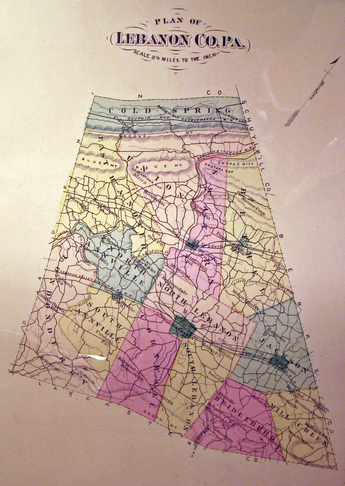
Keep in mind that Lebanon County was formed in 1813 from parts of Dauphin and Lancaster Counties. Dauphin County was carved from Lancaster county in 1785. Lancaster County was created from Northumberland County in 1772, etc. Thus, depending on the year, Lebanon County warrantees and patentees will be found in Berks County, Bucks County, Dauphin County, Lancaster County, Lebanon County, Philadelphia County, Schuylkill County, and the “Old Rights Register.“
We have compiled an index of the warrantees and patentees from all of Mr. Wolfson’s 16 township booklets on file at the Library of Congress and are posting that index here as two .pdf files (one index by name, and the other one by township) so that you will know which booklet to order from one of the repositories. Be sure to open the “Bookmarks” tab for quicker searching. Also, be aware that a name may appear more than once on several pages and in both the warrantee and patentee column of a page, so be sure to search all pages of the relevant township:

 Click on the township of your choice below. Once the images are loaded, they can be enlarged by clicking on them. If an image doesn’t enlarge, right-click on it and choose “Open Image in New Tab.” When it is opened in a new tab, you will be able to zoom in. You can also save the images. They are fairly large images so may require some time to fully load.