
Mercer County Resources

Ancestor Tracks is committed to becoming a one-stop resource for researchers of early Pennsylvania landowners. In addition to publishing our own books, we are posting images of 19th century maps and atlases that we personally took in the Library of Congress. Our goal is to post landowner maps, or links to other websites with landowner maps, for every county in the state.
Original Land Owners
The draftsmen at the Pennsylvania Land Office used the Warrant and Patent Registers to create the Warrantee Maps showing the first individuals to receive their land directly from the colony or state of Pennsylvania (see links to the Warrantee Maps below the 1860 map images). The draftsmen searched each county and parent county, then each alphabetical section chronologically, in the set of 67 county Warrant Registers plus 3 pre-1733 ledgers called First Landowners of PA: Colonial and State Warrant Registers in the PA Archives, Harrisburg, 1682-ca 1940 ($35) which can now be downloaded and saved to your computer. (Free images are also posted on the Pennsylvania State Archives website where each page of each county’s ledger is a separate pdf file). The Pennsylvania State Archives has posted the online survey books (both front and back side of each survey have been digitized) and you can order copies of the original documents from the Pennsylvania State Archives in Harrisburg using their order form.
The draftsmen also searched Pennsylvania’s index to Patent Registers ($35). Within an index covering the relevant years, the names are grouped alphabetically by the first letter of the patentee’s surname, then grouped by volume number of Patent Book, and finally arranged chronologically by date of patent. Thus, the entire alphabetical section must be searched (which may be as little as one page to as many as 50) so as not to miss anyone.
Mercer County was created in 1800 from Allegheny County which was itself created in 1785 from Washington and Westmoreland Counties. Thus, for any pre-1800 settlers, check Allegheny County and Westmoreland County for deeds and wills, etc. It was also part of the Last Purchase so check the Last Purchase Warrant Register.
This area was part of the Donation Lands given to Revolutionary War soldiers based on their rank, so locating an ancestor here definitely warrants further research into Revolutionary War records. Any Revolutionary War pension or service record will probably be on file in state archives rather than federal records since the land was given by the state of Pennsylvania. Note that land records may be the only piece of evidence that your ancestor served in the Revolutionary War!
To learn about the Pennsylvania Land Acquisition process that England set up to distribute colonial land (which basically continues today), as well as the boundary disputes (between Pennsylvania and Maryland, Pennsylvania and Virginia, and Pennsylvania and Connecticut) and land opened through treaties with Indians, see our Land Acquisition page.
19th-Century Residents
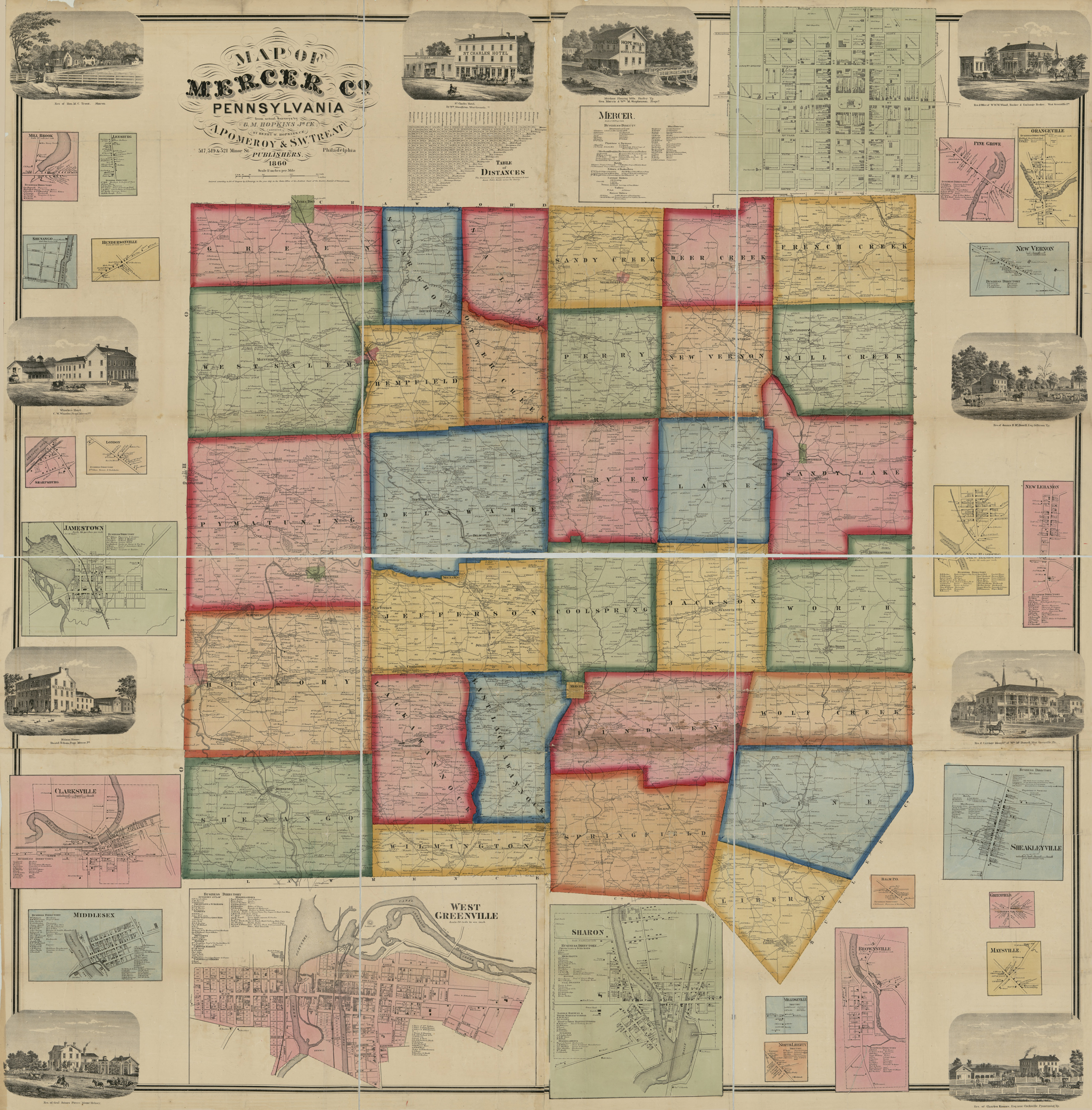
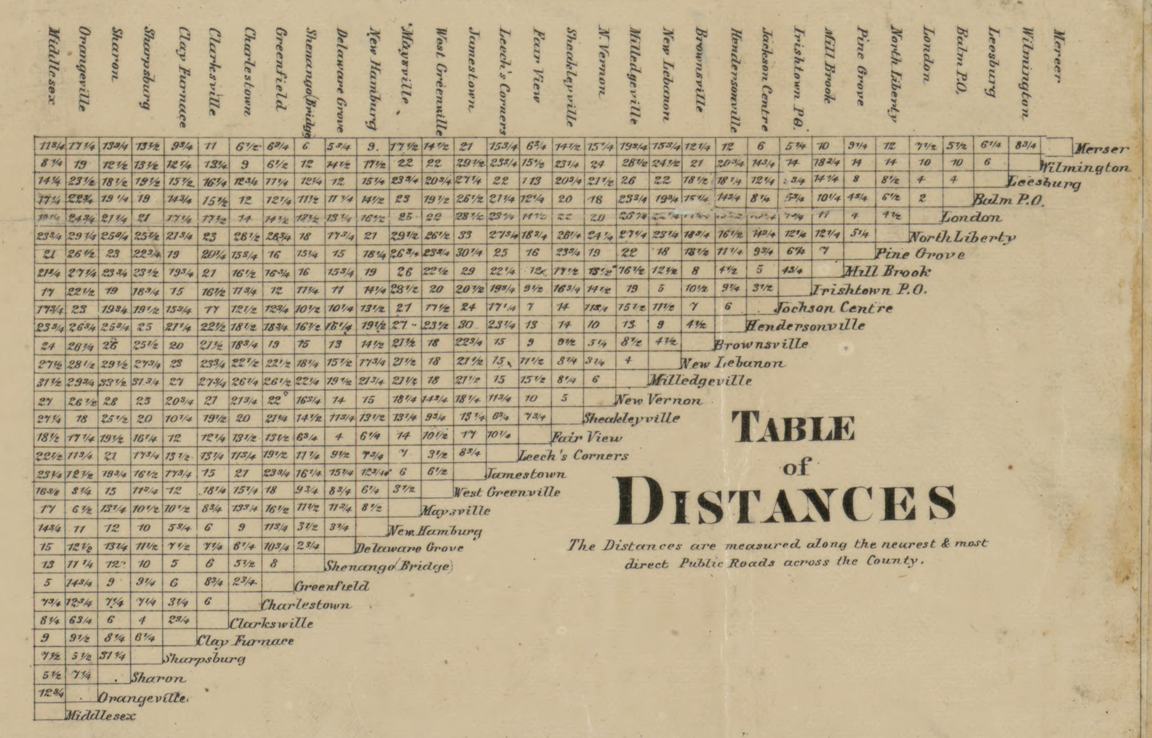
We are posting images from Map of Mercer Co, Pennsylvania by G. M. Hopkins which was published in 1860. This map is located in the Library of Congress Geography and Map Division Washington, D.C. We hope that it will be a useful tool for locating your Mercer County families when coupled with the 1860, 1870 and 1880 census records, as well as four county histories: (1) Samuel Durant’s 1877 History of Mercer County, Pennsylvania, with Illustrations Descriptive of Its Scenery; (2) Jacob Richard’s 1888 History of Mercer County, Pennsylvania: Its Past and Present; (3) McKnight’s 1905 A Pioneer Outline History of Northwestern Pennsylvania, Embracing the Counties of Tioga, Potter, McKean, Warren, Crawford, Venango, Forest, Clarion, Elk, Jefferson, Cameron, Butler, Lawrence, and Mercer; and (4) A Twentieth Century History of Mercer County, Pennsylvania (Volume 1 and Volume 2) .
Images from the 1873 Combination Atlas of Mercer County and the State of Pennsylvania are online at the Mercer Co. PA Genweb Project site. Many thanks are due to the wonderful people who scanned these images and are making them available to researchers! This 1873 atlas should be used when you find your ancestors on the 1850-1880 censuses, as well as published county histories above. Many of the families documented in A Twentieth Century History are shown on the 1873 atlas.
Cindy Boooth Maher maintains an excellent “Mercer County Genealogy” page on rootsweb. Pay special attention to how the townships evolved over time. Thank you, Cindy, and former long-time coordinator Teri Brown, for the incredible wealth of resources you are bringing to researchers of Mercer County families!
Mercer County Landowner Map by Hopkins, 1860
Click on the township of your choice below. Once the images are loaded, they can be enlarged by clicking on them. If an image doesn’t enlarge, right-click on it and choose “Open Image in New Tab.” When it is opened in a new tab, you will be able to zoom in. You can also save the images. They are fairly large images and may take some time to download.
While the map in the Library of Congress, is in the public domain the images we have taken belong to us and are not to be used for commercial use. For those wishing to use them for personal use (including illustrating a family history you are working on), we give permission to use them, but we would appreciate attribution to Ancestor Tracks. It takes much time and effort to locate, process, edit, and post these and the many other county images we have posted, so we appreciate this courtesy.
1860 Township Residents
Towns and Villages
Coolspring Township
Deer Creek Township
Delaware Township
East Lackawannock Township
Fairview Township
Findley Township
French Creek Township
Greene Township
Hempfield Township
Hickory Township
Jackson Township
Jefferson Township
Lackawannock Township
Lake Township
Liberty Township
Mill Creek Township
New Vernon Township
Otter Creek Township
Perry Township
Pine Township
Pymatuning Township
Salem Township
Sandy Creek Township
Sandy Lake Township
Shenango Township
Springfield Township
Sugar Grove Township
West Salem Township
Wilmington Township
Wolf Creek Township
Worth Township
Mercer County Township Warrantee Maps
Pennsylvania State Archives, Harrisburg
As mentioned above, the Pennsylvania Archives has posted Warrantee Maps showing the very first landowners for all of the townships of Mercer County. Unfortunately, they are not indexed.
Please note that these land transfers were from the colonial or state government to the first private landowners. These transactions predate the deed books located in each county which show transactions from one person to another person. Once the land passed into the hands of a private owner, any subsequent transfer of the land was recorded as deeds in the county courthouse as it existed at that time.
Scroll down to the tutorial we’ve posted below the table to learn how best to use these Warrantee Maps to gain the maximum information regarding your ancestor’s tract.
Original Landowners of Mercer County
Tutorial: The following is an explanation of the descriptions shown on each tract. Refer to the tract owned by Private Samuel ALLEN in the northwest corner of the Coolspring Township map for this discussion. You will see that 200 acres and an allowance of 6% for roads was warranted to Private Allen, No. 676 and it was surveyed 22 July 1785 and recorded in Survey Book C181, pg. 56. Then it was patented 6 Nov 1786. These individual surveys have been posted online by the Pennsylvania Archives in Harrisburg. In this case, the survey shows that the tract was issued as “Donation Lands promised the Troops” in an act by the state of Pennsylvania 24 Feb 1785. Tract No. DCLXXVI (676) was situated in District No. 4 on the west side of Allegheny River in (then) Westmoreland County. The fact that he was entitled to Donation Land indicates that he fought through the Revolutionary War until its end. It does not mean, however, that he enlisted in Mercer County, only that he received land in Mercer Co. in lieu of hard currency.
Can we find out more about Pvt. Samuel Allen? The original Donation Land Registers have been posted. We know the number of Allen’s tract (676) so the easiest approach is to look under “Numerical Listing of Donation Land Tracts” under District 4. If the survey book and page number had not been entered on the Warrantee Map, this would be the only source to locate it. Under “Listing of Veterans Entitled to Land,” pg. 1, we see that Samuel Allen served in the 1st Battalion of Infantry as a private. A search through “Donation Claimant Papers” under “Surnames beginning with ‘A” brings up the image of the original 2 Oct 1786 Power of Attorney granted (and signed) by Samuel Allen (pg. 28). He granted power to Mr. Richd Renshaw to “Act in all Cafes Nefary” to obtain a patent for his donation land and shows that he was in the Pennsylvania Line. Witnesses were Thomas Johns and William Jones. These papers are not indexed or alphabetized under the letter A, so they must be examined individually.
Also, look in Twentieth Century History of Mercer County, Pennsylvania and other county histories (links are above) for family information and search the Digital Library of Historic Pittsburgh as well as the published Pennsylvania Archives (free on Fold3).
Obviously, not all of the land in Mercer Co. went to soldiers. Adjoining Allen at the southeast corner in Coolspring Twp. is Aaron Church. According to this Warrantee Map, Church received a warrant dated 21 Apr 1794, it was surveyed 23 May 1795 (recorded in Survey Book C29, pg. 108), and it was patented 11 July 1826 to Robert Bowman (recorded in Patent Register H23, pg. 623). Sometimes there are many years between each of the three steps (warrant, survey & patent) in finalizing the title of the first landowner and the tract may have passed through several hands before the patent is granted since each step involved paying a fee; in this case it officially passed to another owner long after Church warranted it, but it may have passed through several hands unofficially.