Monroe County - Early Landowners

Ancestor Tracks is committed to becoming a one-stop resource for researchers of early Pennsylvania landowners. In addition to publishing our own books, we are posting images of 19th century maps and atlases that we personally took in the Library of Congress. Our goal is to post landowner maps, or links to other websites with landowner maps, for every county in the state.

Original Land Owners

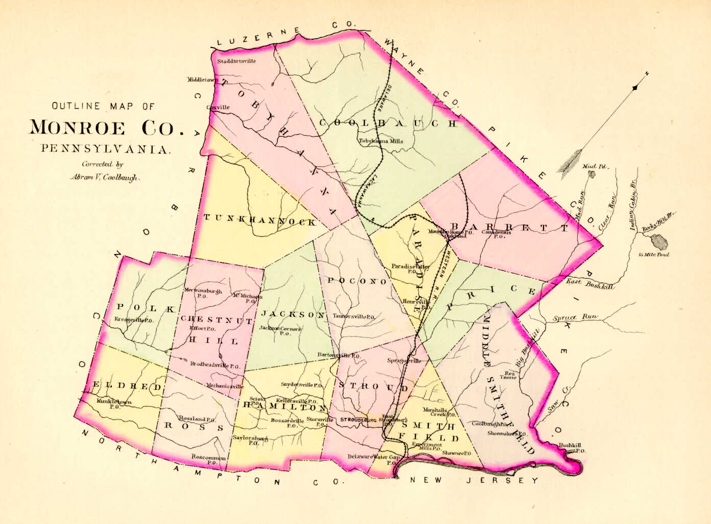
Starting in 1907, the Pennsylvania Land Office began  platting the exact metes-and-bounds tracts of the original landowners, township-by-township but the Land Office only completed about 1/3 of the state before the project ended. The land office only completed mapping the first landowners of one township in Monroe County, Coolbaugh Township (see links below). 

If your ancestor was actually a first landowner, purchasing his or her property from the colony or state of Pennsylvania, further information about these tracts may be gleaned from the Warrant and Patent Registers.

The only way to find the date, book and page of the original warrant, survey, and patent for your ancestor is to do what the state draftsmen did to create their warrantee maps of other counties.  They searched through the relevant county Warrant Register, and that of its parent counties, now posted on the Pennsylvania State Archives website where each page of each county’s ledger is a separate pdf file, or download and save to your computer the entire set of 67 county Warrant Registers plus 3 pre-1733 ledgers called First Landowners of PA: Colonial and State Warrant Registers in the PA Archives, Harrisburg, 1682-ca 1940 ($35).   

Once you have found the information, including the Survey Book and page number, you can access the free online surveys.  You can also order copies of the original documents from the Pennsylvania State Archives in Harrisburg using their order form

If you cannot find an original landowner’s name in the Warrant Registers, the next place to look is in Pennsylvania’s index to Patent Registers ($35). Within an index covering the relevant years, the names are grouped alphabetically by the first letter of the patentee’s surname, then grouped by volume number of Patent Book, and finally arranged chronologically by date of patent. Thus, you have to look through the entire alphabetical section (which may be as little as one page to as many as 50) to be sure you don’t miss anyone. See our explanation of how land was transferred from the government to individual owners from the earliest days of settlement.

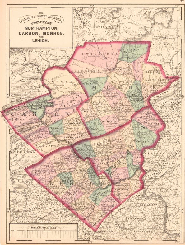
Keep in mind that Monroe County was created from Pike and Northampton Counties in 1836.  In turn, Pike was created from Wayne County in 1814 (Wayne was part of Northampton County until 1798), and Northampton was formed from Bucks County in 1751.  These dates are important, as the earliest land warrants were filed under the county as it existed at the time the warrant was issued.  Thus, you will have to search all relevant counties for land records, wills, court records, and church records depending on when your ancestor settled here. 

Monroe County Township Warrantee Maps

The following Township Warrantee Maps have been placed online by the Pennsylvania Archives in Harrisburg.  It appears that these are the only townships for which Commonwealth of Pennsylvania draftsmen connected the surveys and patents and created a complete Township Warrantee Map.

These land transfers predate the deed books located in each county because they deal with the first transfer of land to private individuals from Pennsylvania’s colonial or state government.  Once the land passed into the hands of a private owner, any subsequent transfer of the land was recorded as deeds in the county courthouse as it existed at that time.  

Coolbaugh Data Sheet
Numbers on this Data Sheet refer to numbers on the Warrantee Map (see link below). Data included on this sheet include the size of the tract; dates of the warrant, survey and patent; name of the person who received the patent, or final title; and Patent Book and page number. This is the same information obtained through the set of 67 county Warrant Registers plus 3 pre-1733 ledgers called First Landowners of PA: Colonial and State Warrant Registers in the PA Archives, Harrisburg, 1682-ca 1940 ($35).
Coolbaugh Warrantee Map
The letter and number below each name refers to the Survey Book and page number; the circled number on each tract refers to the Data Sheet where you will find the size of the tract (see link above); dates of the warrant, survey and patent; name of the person who received the patent, or final title; and Patent Book and page number. This is the same information obtained through the set of 67 county Warrant Registers plus 3 pre-1733 ledgers called First Landowners of PA: Colonial and State Warrant Registers in the PA Archives, Harrisburg, 1682-ca 1940 ($35).


19th-Century Residents

As we have done for numerous Pennsylvania counties (hover over each county on the PA map to see what we have uploaded), we are posting completely free, downloadable township images from Map of the Counties of Monroe and Carbon, Pennsylvania From surveys under the direction of H. F. Walling. (New York, 1860).  We hope that you will find this atlas a useful tool for when coupled with the 1850, 1860, 1870 and 1880 census and published county histories: Daniel Rupp’s 1845 History of Northampton, Lehigh, Monroe, Carbon, and Schuylkill Counties; Alfred Mathews’ 1886 History of Wayne, Pike and Monroe Counties, Pennsylvania; and Robert Brown Keller’s 1927 History of Monroe County, Pennsylvania, in the FamilySearch Library and at the Penn State University Digital Collections.  Also see the 1860 zoomable map of Monroe and Carbon Counties in the Leventhal Map Collection of Boston Public Library.
Monroe County, 1860

Click for Distance Table

Click on the township of your choice below. Once the images are loaded, they can be enlarged by clicking on them. If an image doesn’t enlarge, right-click on it and choose “Open Image in New Tab.”  When it is opened in a new tab, you will be able to zoom in. You can also save the images.

While the map in the Library of Congress, is in the public domain the images we have taken belong to us and are not to be used for commercial use. For those wishing to use them for personal use (including illustrating a family history you are working on), we give permission to use them, but we would appreciate attribution to Ancestor Tracks. It takes much time and effort to locate, process, edit, and post these and the many other county images we have posted, so we appreciate this courtesy.