Ancestor Tracks is committed to becoming a one-stop resource for researchers of early Pennsylvania landowners. In addition to publishing our own books, we are posting free images of 19th century maps and atlases that we personally took in the Library of Congress. Our goal is to post landowner maps, or links to other websites with landowner maps, for every county in the state.
Original Land Owners
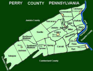
The state of Pennsylvania began platting the exact metes-and-bounds tracts of the earliest landowners, township-by-township, starting in 1907, but the Land Office only completed about 1/3 of the state before the project ended. Unfortunately, Pennsylvania did not plat Perry County. See our explanation of how land was transferred from the government to individual owners from the earliest days of settlement.
Researchers are indeed fortunate, however, that Hayes R. Eschenmann began to systematically research and map the tracts of the earliest landowners of Columbia County, aligning their surveys with USGS topographic quadrangle maps. He published volumes for four Columbia County quadrangles before his passing, and his project was taken up by his editor, Paul Barner, who completed the rest of the county plus 11 maps for Perry County.
The Barner pamphlets will probably give you enough data to access copies of the warrant, original survey, and patent in the Pennsylvania State Archives, but if you need to find the date, book and page of the original warrant, survey, and patent for your ancestor, you will need to search through the Cumberland County Warrant Register on the Pennsylvania State Archives website where each page of each county’s ledger is a separate pdf file, or download and save to your computer the entire set of 67 county Warrant Registers plus 3 pre-1733 ledgers called First Landowners of PA: Colonial and State Warrant Registers in the PA Archives, Harrisburg, 1682-ca 1940 ($35). Once you have found the information, you can access the free online surveys, and you can order copies of the original documents from the Pennsylvania State Archives in Harrisburg using their order form. Please note that these land transfers predate the deed books located in each county because they deal with the first transfer of land to private individuals at the state level.
If you cannot find an original landowner’s name in the Warrant Registers, the next place to look is in Pennsylvania’s index to Patent Registers ($35). Within an index covering the relevant years, the names are grouped alphabetically by the first letter of the patentee’s surname, then grouped by volume number of Patent Book, and finally arranged chronologically by date of patent. Thus, you have to look through the entire alphabetical section (which may be as little as one page to as many as 50) to be sure you don’t miss anyone.
11 volumes of First Families of Perry County have been published, each of which includes a 22″ X 30″ map showing the tracts, and they may be ordered for $18 each plus shipping and handling. The index to the volumes is available on this site, as well as a key to the Quadrangle abbreviations. The volumes available at Cumberland County Historical Society are:
Volume I: Western Perry Quadrangle
Volume 2: Spruce Hill Quadrangle
Volume 3: Andersonburg Quadrangle
Volume 4: Mexico and Millerstown Quadrangles
Volume 5: Ickesburg Quadrangle
Volume 6: Landisburg Quadrangle
Volume 7: Newport Quadrangle
Volume 8: Shermans Dale Quadrangle
Volume 9: Reward, Millersburg, and Dalmatia Quadrangles
Volume 10: Duncannon and Halifax Quadrangles
Volume 11: Wertzville and the West Shore
Also see this site for three other volumes containing partial Perry County quadrangles.