Ancestor Tracks is committed to becoming a one-stop resource for researchers of early Pennsylvania landowners. In addition to publishing our own books, we are posting images of 19th century maps and atlases that we personally took in the Library of Congress. Our goal is to post landowner maps, or links to other websites with landowner maps, for every county in the state.
Original Land Owners
The state of Pennsylvania began platting the exact metes-and-bounds tracts of the earliest landowners, township-by-township, starting in 1907, and they completed all of Sullivan County many years ago. We have posted links to these Warrantee Maps below (scroll down below the images of the 1872 landowner map).
Sullivan County was created from Lycoming County in 1847. Originally, the area that became Sullivan County was in Northampton County (1752-1772), then Northumberland (1772-1795), then Lycoming (1795-1847). These dates are important because warrants, wills, deeds, etc. were filed in the county as it existed at that time.
Also, the entire northern 1/3 of Pennsylvania was disputed by Connecticut and by Native Americans. Indians finally gave up their claims to Susquehanna County and a huge swath of Pennsylvania through the “New Purchase” of 1768. Those who purchased under the New Purchase had their land applications entered into the New Purchase Register.
To learn about the Pennsylvania Land Acquisition process that England set up to distribute colonial land (which basically continues today), as well as the boundary disputes (between Pennsylvania and Maryland, Pennsylvania and Virginia, and Pennsylvania and Connecticut), Revolutionary War Donation and Depreciation land, and land opened through treaties with Indians, see our Land Acquisition page.
In addition to the New Purchase Register, the draftsmen at the Pennsylvania Land Office used the Warrant and Patent Registers to create the Warrantee Maps. They searched each county and parent county, then each alphabetical section chronologically, in the set of 67 county Warrant Registers plus 3 pre-1733 ledgers called First Landowners of PA: Colonial and State Warrant Registers in the PA Archives, Harrisburg, 1682-ca 1940 ($35) which can now be downloaded and saved to your computer. (Free images are also posted on the Pennsylvania State Archives website where each page of each county’s ledger is a separate pdf file).
The Warrant Registers give the Survey Book and page number onto which the loose survey was copied. The Pennsylvania State Archives has posted the online survey books where you can access the surveys once you know the Survey Book and page number (both front and back side of each survey have been digitized). Using the information from the Warrant Registers, you can order copies of the original documents from the Pennsylvania State Archives in Harrisburg using their order form. The draftsmen also searched Pennsylvania’s index to Patent Registers ($35). Within an index covering the relevant years, the names are grouped alphabetically by the first letter of the patentee’s surname, then grouped by volume number of Patent Book, and finally arranged chronologically by date of patent. Thus, the entire alphabetical section must be searched (which may be as little as one page to as many as 50) so as not to miss anyone.
Please note that these land transfers predate the deed books located in each county because they deal with the first transfer of land to private individuals from Pennsylvania’s colonial or state government. Once the land passed into the hands of a private owner, any subsequent transfer of the land was recorded as deeds in the county courthouse as it existed at that time.
19th-Century Residents
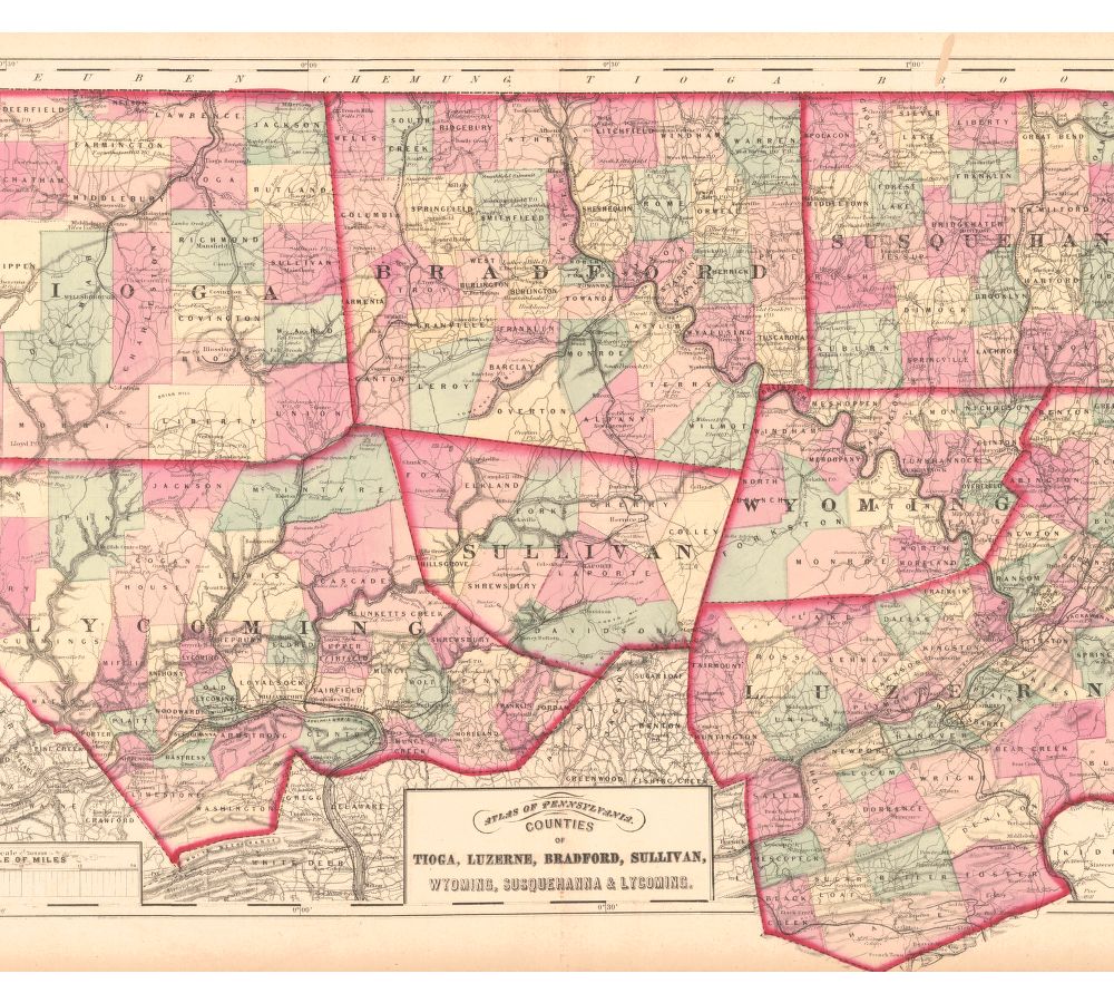
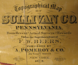
As we have done for numerous Pennsylvania counties (hover over each county on the PA map), we are posting completely free, downloadable township images of from the Topographical Map of Sullivan Co. Pennsylvania. From Recent and Actual Surveys and Records Under the Superindendence of F. W. Beers(A Pomeroy & Co., New York, 1872). We hope that you will find this atlas a useful tool when coupled with the 1860, 1870 and 1880 census and the published histories of the county: the 1899 History of Sullivan County, Pennsylvania by Thomas J. Ingham and the 1903 Memorial Edition History of Sullivan County, Pennsylvania by George Streby.
Also, although we seldom link to non-map sites, the following Rootsweb site is one of the most comprehensive county sites we have ever seen. Be sure to scroll down its page to receive its full value.