
Warren County - Early Landowners
1878 Atlas (scroll below for Warrantee Maps)
Ancestor Tracks is committed to becoming a one-stop resource for researchers of early Pennsylvania landowners. In addition to publishing our own books, we are posting images of 19th century maps and atlases that we personally took in the Library of Congress. Our goal is to post landowner maps, or links to other websites with landowner maps, for every county in the state.
Original Land Owners
The state of Pennsylvania began platting the exact metes-and-bounds tracts of the earliest landowners, township-by-township, starting in 1907, but the Land Office only completed about 1/3 of the state before the project ended. Fortunately, Warren County is one of the completed counties and we are posting links to the township Warrantee Maps showing the metes-and-bounds plats of the first landowners of Warren County (scroll to below the atlas images). See our explanation of how land was transferred from the government to individual owners from the earliest days of settlement and the tutorial below.
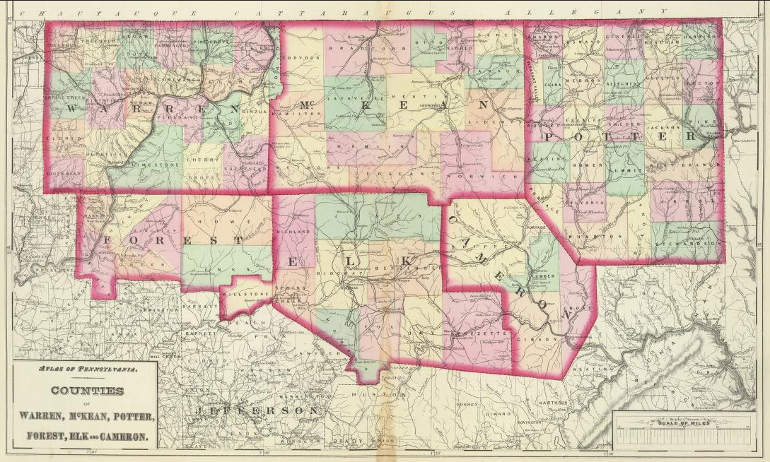
Note that this area was part of the Last Purchase of 1784, and vast areas of land were first purchased from the commonwealth of Pennsylvania by land speculators before being resold to settlers. See the explanation of the Last Purchase on our Elk County page.
Thus, land in Warren County was being sold through two processes after the treaty was signed: (1) through the Last Purchase process, whose warrants are recorded in the Last Purchase Register; and (2) through the normal warrant process, in which case the warrants are recorded in the Warrant Register of the county in which the land resided at that time. Warren County was formed from Allegheny and Lycoming Counties in 1800 but before 1788 it was part of Northumberland County.
If the settler was not in the New Purchase Register, the draftsmen at the Pennsylvania Land Office used the Warrant and Patent Registers to create the Warrantee Maps. They searched each county and parent county, then each alphabetical section chronologically, in the set of 67 county Warrant Registers plus 3 pre-1733 ledgers called First Landowners of PA: Colonial and State Warrant Registers in the PA Archives, Harrisburg, 1682-ca 1940 ($35) which can now be downloaded and saved to your computer. (Free images are also posted on the Pennsylvania State Archives website where each page of each county’s ledger is a separate pdf file). The Pennsylvania State Archives has posted the online survey books (both front and back side of each survey have been digitized) and you can order copies of the original documents from the Pennsylvania State Archives in Harrisburg using their order form.
The draftsmen also searched Pennsylvania’s index to Patent Registers ($35). Within an index covering the relevant years, the names are grouped alphabetically by the first letter of the patentee’s surname, then grouped by volume number of Patent Book, and finally arranged chronologically by date of patent. Thus, the entire alphabetical section must be searched (which may be as little as one page to as many as 50) so as not to miss anyone.
Please note that these land transfers predate the deed books located in each county because they deal with the first transfer of land to private individuals from Pennsylvania’s colonial or state government. Once the land passed into the hands of a private owner, any subsequent transfer of the land was recorded as deeds in the county courthouse as it existed at that time.
19th-Century Residents
As we have done for numerous Pennsylvania counties (hover over each county on the PA map), we are posting completely free, downloadable township images from the 1878 Howden & Odbert’s Atlas of Warren County, Pennsylvania from Actual Surveys & Records by & under the directions of J. A. Howden & A. Odbert (Washington, PA: F. G. Longdon and Wilson Porter, 1878). We hope these maps will be helpful when coupled with the 1860, 1870 and 1880 censuses and published county histories such as McKnight’s 1905 A Pioneer Outline History of Northwestern Pennsylvania, Embracing the Counties of Tioga, Potter, McKean, Warren, Crawford, Venango, Forest, Clarion, Elk, Jefferson, Cameron, Butler, Lawrence, and Mercer and the 1887 History of Warren County, Pennsylvania with Illustrations and Biographical Sketches of Some of its Prominent Men and Pioneers edited by J. S. Schenck (Syracuse, NY: D. Mason & Co., Publishers, 1887). A second version of this History of Warren County has been posted online at PA-Roots–many thanks to Nathan Zipfel for his outstanding work!
Also, Gardiner’s 1881 Map of Warren and Forest Counties has been posted by the Pennsylvania State Archives.
1878 Landowner Atlas of Warren County
(Click on cover above for township map)
Click on the township of your choice below. Once the images are loaded, they can be enlarged by clicking on them. If an image doesn’t enlarge, right-click on it and choose “Open Image in New Tab.” When it is opened in a new tab, you will be able to zoom in. You can also save the images.
While the map in the Library of Congress, is in the public domain the images we have taken belong to us and are not to be used for commercial use. For those wishing to use them for personal use (including illustrating a family history you are working on), we give permission to use them, but we would appreciate attribution to Ancestor Tracks. It takes much time and effort to locate, process, edit, and post these and the many other county images we have posted, so we appreciate this courtesy.
1878 Township Residents
Towns and Villages
Business Directory
Brokenstraw Township
Cherry Grove Township
Columbus Township
Conewango Township
Corydon Township
Deerfield Township
Eldred Township
Elk Township
Farmington Township
Freehold Township
Glade Township
Kinzua Township
Limestone Township
Mead Township
Pine Grove Township
Pittsfield Township
Pleasant Township
Sheffield Township
Southwest Township
Spring Creek Township
Sugar Grove Township
Triumph Township
Tutorial: As mentioned above, the Warrantee Maps showing the original landowners of each township were drafted by the Pennsylvania Land Office, and they have been scanned and posted online by the Pennsylvania Archives. As shown on pg. 122-3 of the county history by Schenck, after the Indian Treaty at Fort Stanwix of 1784 was signed (also called the “Last Purchase”), “…a company of Hollanders seeking an investment of their surplus funds, purchased the claim of John Adlum and Samuel Wallace to a large body of lands in this part of the State. For these they had warrants issued and surveys made in the names of Herman Le Roy and John Linklain. These names were used to evade the law, which, at that time, forbade aliens from holding titles to land in this State. On these warrants most of the land in this county, north and west of the Allegheny River and Conewango Creek, was surveyed and appropriated and originally owned by the Holland Land Company….”
According to the description by the Pennsylvania Archives, “Speculators of the Pennsylvania Population Company and the Holland Land Company took advantage of this provision [granting exceptions to the law requiring proof that warrantees had settled on the land for 5 years if they were “prevented from occupying their land by enemies of the United States” if they produced a letter from the deputy surveyor attesting the “prevention”] to buy up large numbers of warrants directly through the Land Office under fictitious names….To eliminate collusion between speculators and deputy surveyors, from 1799 county survey districts were redrawn and new deputy surveyors were appointed. The Commonwealth Supreme Court also reversed the Board of Property decision and ruled that the warrantee must show actual proof of settlement within two years of the date that military prevention ceased.”
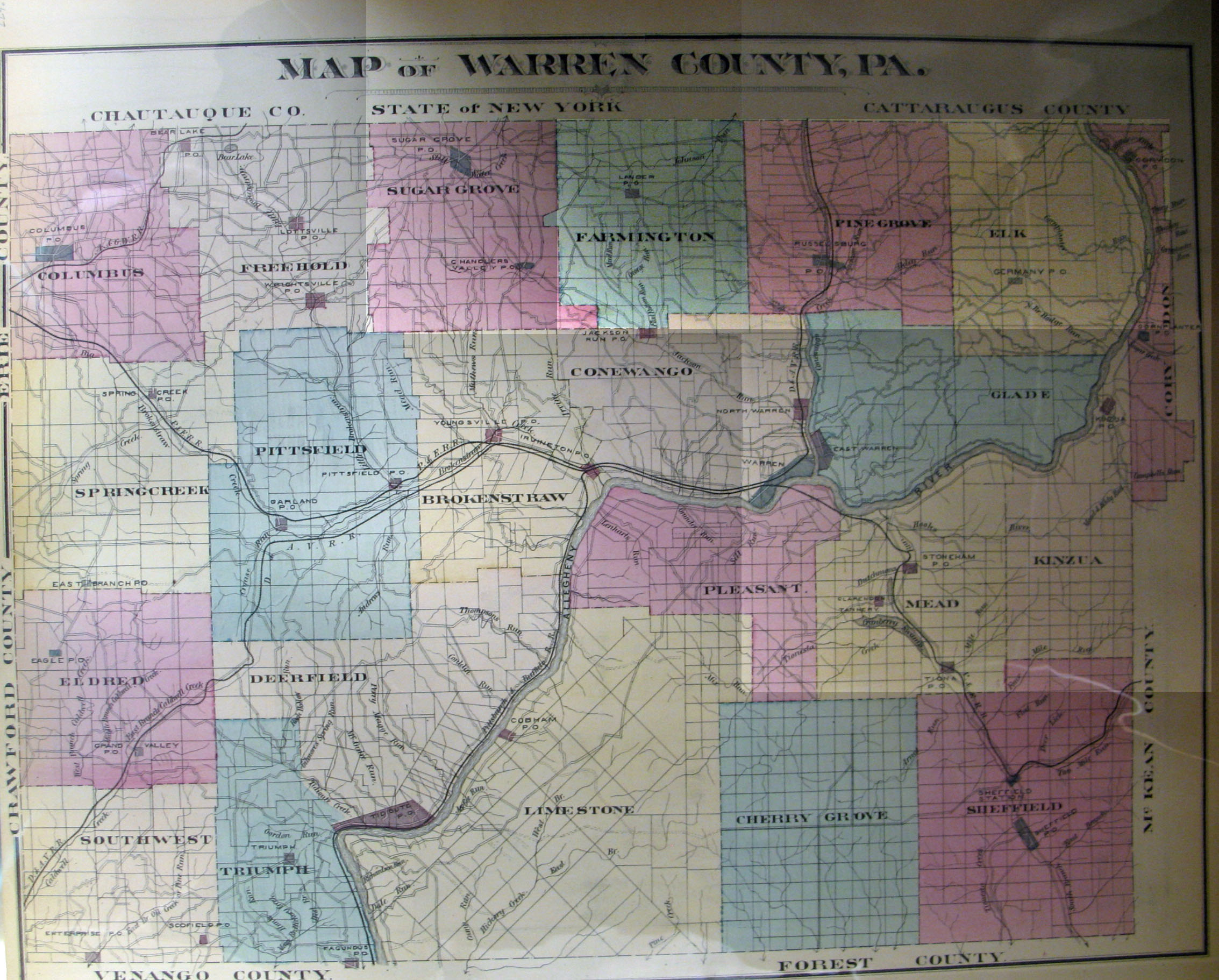
Brokenstraw Township at the time the warrant was issued in 1793 belonged to Allegheny County. Compare the atlas version of Brokenstraw Township posted above with the Warrantee Map of Brokenstraw Township below, for example, and you will see Tract #307 at the top of the township. By comparing that with the Township Warrantee Map below, it appears that the draftsman labeled the equivalent tract #5 (the broken lines delineate the township boundaries) so that he could write the particulars of the land transfers in the margin. The entry for #5 in the margin indicates that Aaron Dale (who may or may not have been fictional) was given a warrant on 10 Apr 1793, that the tract was surveyed on 9 Sep 1794 and contained 434 acres and allowance (the Commonwealth of Pennsylvania, continuing the practice initiated under colonial rule, required that 6% of virtually every tract be set aside for official uses such as roads), and that it was patented 8 Feb 1799 to Wilhem Willink, et. al. The tract was named “Elklick.” The entry further shows that the patent was recorded in Patent Register 38, pg. 195, and that the survey was recorded in Survey Book C46, pg. 112. Every fact listed here can be verified, and original documents referring to this tract can be ordered from the Pennsylvania Archives. An explanation of the process follows.
Warrant Register: A search of the Last Purchase Register did not reveal a warrant for Aaron Dale, but he is listed in the Allegheny County Warrant Register. His entry (under the letter “D”) in the ledger shows that he received a warrant for 400 acres on 10 Apr 1793, that the survey containing 434 acres was returned for patenting 7 Feb 1799 to Wilhelm Willink. It confirms that the patent was recorded in Patent Register P38, pg. 195, and that the survey was recorded in Survey Book C46, pg. 112. According to the Allegheny Co. Warrant Register, a remarkable number of Dales were awarded separate warrants on that 10 April date: Sarah, Jonas, David, Daniel, Eliza, Noah, Hannah, Ann, Philip, Isaac, Peter, Israel, Grace, Roger, John, George, Elihu, James, Matthew, Aaron, Enoch, Owen, Paul, Edward, Aaron, Mark, Samuel, Benjamin, Robert, John, Nathan, Moses, George, Richard, William, Mary, Simon, Caleb, Luke, and Lydia. All of these tracts were patented to Wilhelm Wilink between 30 January and 11 February 1799–highly coincidental indeed, especially given the new law of 1799 tightening the requirements! None of these names are mentioned in the chapter on Brokenstraw Township in the History of Warren County (pp. 401-420) which details nearly all of the settlers prior to 1806 in the township.
Survey: Survey Book C46, pg. 112. The survey shows that his tract was surrounded by those of Matthew Dale, Israel Dale, Noah Dale and Jonas Dale.
Patent: The index to Patent Register P38, pg. 195, confirms that Wilhem Willink, et. al., patented 434 acres called “Elk-Lick” on 8 Feb 1799 which had been warranted to Aaron Dale on 10 Apr 1793. The numbers on the tracts in the 1878 atlas refer to numbers assigned to the tracts purchased under the 1784 “Last Purchase” and the sale warrants are recorded in the Last Purchase Warrant Register at the Pennsylvania Archives in Harrisburg. The warrants can be searched by scrolling through the pages under the first initial of the surname of the purchaser. Thus, Tract #2579 appears on pg. 48 (under “W”) which verifies that it was granted on 12 Dec 1792 to “Willink, Wilhem and others” with an estimated size of 900 acres. The survey was returned for patenting to Silas X. Billings on 20 Apr 1874 with an actual size of 1002 acres. It confirms that the Patent was recorded in Patent Register H72, pg. 672 (since the patentee was Silas Billings, his patent was indexed under the letter “B” in the Patent Index Registers). The last column in the Last Purchase Register shows that the survey is recorded in Survey Book D7, pg. 127, which has been posted online with all other surveys by the Pennsylvania Archives. See the explanation of the Last Purchase of 1784 on our Elk County page and a map showing the Last Purchase counties in yellow).
Warren County Township Warrantee Maps
Repository: Pennsylvania State Archives, Harrisburg
Warrantee Maps – First Landowners
Brokenstraw Township
Cherry Grove Township
Columbus Township
Conewango Township
Deerfield Township
Eldred Township
Elk Township
Farmington Township
Freehold Township
Glade Township
Limestone Township
Meade Township (North)
Meade Township (South)
Pine Grove Township
Pittsfield Township
Pleasant Township
Sheffield Township
Southwest Township
Spring Creek Township
Sugar Grove Township
Triumph Township
Watson Township (northern part of Limestone Twp. until 1880,
thus not shown separately on the 1875 map above)