
Wayne & Pike Counties

Ancestor Tracks is committed to becoming a one-stop resource for researchers of early Pennsylvania landowners. In addition to publishing our own books, we are posting images of 19th century maps and atlases that we personally took in the Library of Congress. Our goal is to post landowner maps, or links to other websites with landowner maps, for every county in the state.
Original Land Owners
The state of Pennsylvania began platting the exact metes-and-bounds tracts of the earliest landowners, township-by-township, starting in 1907, but the Land Office only completed about 1/3 of the state before the project ended. Fortunately, two of the counties they completed were Wayne and Pike. We have posted links to these free Township Warrantee Maps – scroll below the 1860 map images to see them.
Also, Jason Torrey, surveyor of Wayne and Pike Counties, drew the first landowner map of Wayne and Pike Counties in 1814 ($10). Torrey was one of the first settlers in the county and met the pioneers himself, often taking meals with them; he climbed over hills and cleared trails through the woods in order to set out his compass and chain; he endured rain and sleet, mosquitoes and frost, and he knew the land and its owners more intimately than any other person living in his day. He traveled constantly to the Land Office in Philadelphia, was personally involved in the disputes of overlapping tracts, recorded the surveys in Philadelphia, and represented larger landowners in their land transactions.
In addition to drafting his map, a copy of which we purchased, Jason Torrey created an index of the landowners which we transcribed. His index, however, only contains the name of the land holder, the size of the tract, and the number of the tract within each township. To see the online survey of each tract, you will need to consult the county Warrant Registers. The bulk of settlers seem to have surveyed their land in the 1780s and a bit later.
Wayne and Pike Counties were originally part of Northampton County until Wayne County (which then included Pike County) was created in 1798. Pike remained part of Wayne until it was detached as its own county in 1814. These dates are important because warrants, wills, deeds, etc. were filed in the county as it existed at that time. If they purchased land in present-day Pike County after Wayne was created but before Pike was formed in 1814, they will be in the Wayne County Warrant Register.
Also, the entire northern 1/3 of Pennsylvania, including Wayne and Pike, was disputed by Connecticut and by Native Americans. Indians finally gave up their claims to Susquehanna County and a huge swath of Pennsylvania through the “New Purchase” of 1768. Those who purchased under the New Purchase had their land applications entered into the New Purchase Register.
To learn about the Pennsylvania Land Acquisition process that England set up to distribute colonial land (which basically continues today), as well as the boundary disputes (between Pennsylvania and Maryland, Pennsylvania and Virginia, and Pennsylvania and Connecticut), Revolutionary War Donation and Depreciation land, and land opened through treaties with Indians, see our Land Acquisition page.
In addition to the New Purchase Register, the draftsmen at the Pennsylvania Land Office used the Warrant and Patent Registers to create the Warrantee Maps. They searched each county and parent county, then each alphabetical section chronologically, in the set of 67 county Warrant Registers plus 3 pre-1733 ledgers called First Landowners of PA: Colonial and State Warrant Registers in the PA Archives, Harrisburg, 1682-ca 1940 ($35) which can now be downloaded and saved to your computer. (Free images are also posted on the Pennsylvania State Archives website where each page of each county’s ledger is a separate pdf file). The Warrant Registers give the Survey Book and page number onto which the loose survey was copied. The Pennsylvania State Archives has posted the online survey books where you can access the surveys once you know the Survey Book and page number (both front and back side of each survey have been digitized). Using the information from the Warrant Registers, you can order copies of the original documents from the Pennsylvania State Archives in Harrisburg using their order form. The draftsmen also searched Pennsylvania’s index to Patent Registers ($35). Within an index covering the relevant years, the names are grouped alphabetically by the first letter of the patentee’s surname, then grouped by volume number of Patent Book, and finally arranged chronologically by date of patent. Thus, the entire alphabetical section must be searched (which may be as little as one page to as many as 50) so as not to miss anyone.
Please note that these land transfers predate the deed books located in each county because they deal with the first transfer of land to private individuals from Pennsylvania’s colonial or state government. Once the land passed into the hands of a private owner, any subsequent transfer of the land was recorded as deeds in the county courthouse as it existed at that time.
19th-Century Residents
The Topographical Map of Pike County From Recent and Actual Surveys and Records published by Beers in 1872 has been posted online by the Pennsylvania State Archives as well as the Library of Congress. While they are free and show many landowners and landmarks such as churches, many other tracts are not labeled by name.
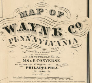
As we have done for numerous Pennsylvania counties (hover over each county on the PA map), we are posting free, downloadable township images of the 1860 Hopkins Map of Wayne Co., Pennsylvania, Drawn from Entirely New & Original Surveys.
Wayne County, 1860
Click on the township of your choice below. Once the images are loaded, they can be enlarged by clicking on them. If an image doesn’t enlarge, right-click on it and choose “Open Image in New Tab.” When it is opened in a new tab, you will be able to zoom in. You can also save the images.
While the map in the Library of Congress, is in the public domain the images we have taken belong to us and are not to be used for commercial use. For those wishing to use them for personal use (including illustrating a family history you are working on), we give permission to use them, but we would appreciate attribution to Ancestor Tracks. It takes much time and effort to locate, process, edit, and post these and the many other county images we have posted, so we appreciate this courtesy.
1860 Township Residents
Boroughs, Towns, and Villages
Berlin Township
Buckingtham Township
Canaan Township
Cherry Ridge Township
Clinton Township
Damascus Township
Dyberry Township
Lebanon Township
Manchester Township
Mount Pleasant Township
Oregon Township
Palmyra Township
Paupack Township
Preston Township
Salem Township (includes Lake)
Scott Township
South Canaan Township
Starrucca Township
Sterling Township (includes Dreher and Lehigh)
Texas Township
Township Warrantee Maps in the Pennsylvania State Archives
The following Township Warrantee Maps, showing the metes-and-bounds plats of the first landowners of the county, have been placed online by the Pennsylvania State Archives in Harrisburg (the maps below are large and will take time to completely download).
Warrantee Maps – First Landowners
Berlin Township (Wayne)
Blooming Grove Township (Pike)
Buckingham Township (Wayne)
Canaan Township (Wayne)
Cherry Ridge Township (Wayne)Clinton Township (Wayne)
Damascus Township (Wayne)
Delaware Township (Pike)
Dingman Township (Pike)
Dreher Township (Wayne)
Dyberry Township (Wayne)
Greene Township (Pike)
Lackawaxen Township (North section) (Pike)
Lackawaxen Township (South section) (Pike)
Lake Township (Wayne)
Lebanon Township (Wayne)
Lehigh Township (Wayne)
Lehman Township (Pike)
Manchester Township (Wayne)
Milford Township (Pike)Mount Pleasant Township (Wayne)
Oregon Township (Wayne)
Palmyra Township (Pike)
Palmyra Township (Wayne)
Paupack Township (Wayne)
Porter Township (Pike)Preston Township (Wayne)
Salem Township (Wayne)
Scott Township (Wayne)
Shohola Township (Pike)South Canaan Township (Wayne)Sterling Township (Wayne)
Texas Township (Wayne)
Westfall Township (Pike)