Ancestor Tracks is committed to becoming a one-stop resource for researchers of early Pennsylvania landowners. In addition to publishing our own books, we are posting images of 19th century maps and atlases that we personally took in the Library of Congress. Our goal is to post landowner maps, or links to other websites with landowner maps, for every county in the state.
Original Land Owners
The state of Pennsylvania began platting the exact metes-and-bounds tracts of the earliest landowners, township-by-township, starting in 1907, but they only completed one township of York County, Warrington Township, before the project was ended (the letter and numbers above the warrantee’s name are the Survey Book and page number; note that this is a large file which will take time to download).
See our explanation of how land was transferred from the government to individual owners from the earliest days of settlement. The only way to find the date, book and page of the original warrant, survey, and patent for each original landowner is to search the county Warrant Register for him or her in the correct alphabetical section and then chronologically on the Pennsylvania State Archives website where each page of each county’s ledger is a separate pdf file, or download and save to your computer the entire set of 67 county Warrant Registers plus 3 pre-1733 ledgers called First Landowners of PA: Colonial and State Warrant Registers in the PA Archives, Harrisburg, 1682-ca 1940 ($35). Once you have found the information, you can access the free online surveys, and you can order copies of the original documents from the Pennsylvania State Archives in Harrisburg using their order form Please note that these land transfers predate the deed books located in each county because they deal with the first transfer of land to private individuals from Pennsylvania’s colonial or state government.
If an original landowner’s name can’t be found in the Warrant Registers, the next place to look is in Pennsylvania’s index to Patent Registers ($35). Within an index covering the relevant years, the names are grouped alphabetically by the first letter of the patentee’s surname, then grouped by volume number of Patent Book, and finally arranged chronologically by date of patent.
We are indeed fortunate that a private individual has given York County researchers a gift of his talent. Over many years, Rev. Neal Hively painstakingly created connected draft maps of the original owners of land in two counties (York and Adams), thus performing a priceless service for genealogists. These maps show the boundaries of the tracts on topographic maps, warrantees of the tracts, and the survey number of each. Rev. Hively tells me that he has retired and has transferred his York County stock and copyright to the York County History Center in York, PA. Some libraries, including the Library of Congress and the DAR Library in Washington, D.C., have his publications which should not be missed if you have early ancestors in York County.
19-Century Residents
As we have done for numerous Pennsylvania counties (hover over each county on the PA map), we are posting free, downloadable township images of from Atlas of York County, Pennsylvania. Illustrated from actual Surveys by and under the direction of Beach Nichols. Published by Pomeroy, Whitman and Co.(Philadelphia, 1876). We hope that you will find this atlas a useful tool for when coupled with the 1860, 1870 and 1880 census and downloadable published county histories: Carter & Glossbrenner’s ca 1834 History of York County from its Erection to the Present Time, 1729-1834; John Gibson’s 1886 History of York County, Pennsylvania: from the Earliest Period to the Present Time; and George Prowell’s 2-volume History of York County, Pennsylvania (Volume I and Volume II) published in 1907.

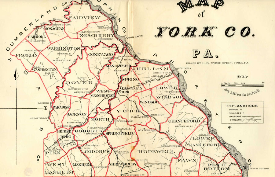
 Atlas of York County, 1876