
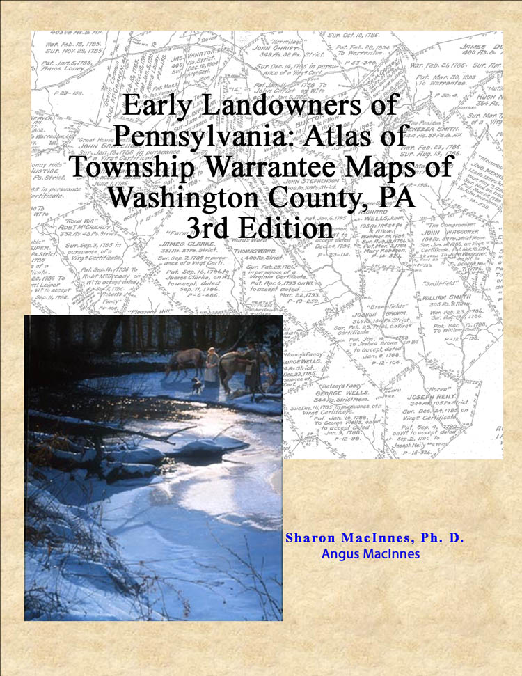
Washington County: Early Landowners of Washington County
2020 Revision Published by Ancestor Tracks
(scroll Down for free 1856 map showing residents)
Ancestor Tracks is committed to becoming a one-stop resource for researchers of early Pennsylvania landowners. In addition to publishing our own books, we are posting images of 19th century maps and atlases that we personally took in the Library of Congress. Our goal is to post landowner maps, or links to other websites with landowner maps, for every county in the state.
Original Land Owners
On this page you will find a newly revised (2020) edition of our Washington County atlas for sale, first published in 2004. It contains all of the Township Warrantee Maps drafted by the Pennsylvania Land Office in the 1920s when they worked on a project to research the original surveys and locate them once and for all on maps of current townships.
Washington County was included in the area disputed between Virginia and Pennsylvania until 1780. It was also part of the “New Purchase,” land opened after an Indian treaty at Fort Stanwix in 1768. To learn about the Pennsylvania Land Acquisition process that England set up to distribute colonial land (which basically continues today), as well as the boundary disputes (between Pennsylvania and Maryland, Pennsylvania and Virginia, and Pennsylvania and Connecticut), Revolutionary War Donation and Depreciation land, and land opened through treaties with Indians, see our Land Acquisition page.
The draftsmen at the Pennsylvania Land Office painstakingly platted the metes-and-bounds of each original tract into current township boundaries using the Warrant and Patent Registers to create the Warrantee Maps. They searched each county and parent county, then each alphabetical section chronologically, in the set of 67 county Warrant Registers plus 3 pre-1733 ledgers called First Landowners of PA: Colonial and State Warrant Registers in the PA Archives, Harrisburg, 1682-ca 1940 ($35) which can now be downloaded and saved to your computer. (Free images are also posted on the Pennsylvania State Archives website where each page of each county’s ledger is a separate pdf file). Nearly all of the individual loose surveys were gathered together and copied into ledgers early in the 20th century, and we are indeed fortunate that the Pennsylvania State Archives has posted these “Copied Survey Books” online. To find the Survey Book and page number, consult the “Survey Book” column in this atlas (check both front and back sides). You order copies of the original documents from the Pennsylvania State Archives in Harrisburg using their order form.
The draftsmen also searched Pennsylvania’s index to Patent Registers ($35). Within an index covering the relevant years, the names are grouped alphabetically by the first letter of the patentee’s surname, then grouped by volume number of Patent Book, and finally arranged chronologically by date of patent. Thus, the entire alphabetical section must be searched (which may be as little as one page to as many as 50) so as not to miss anyone.
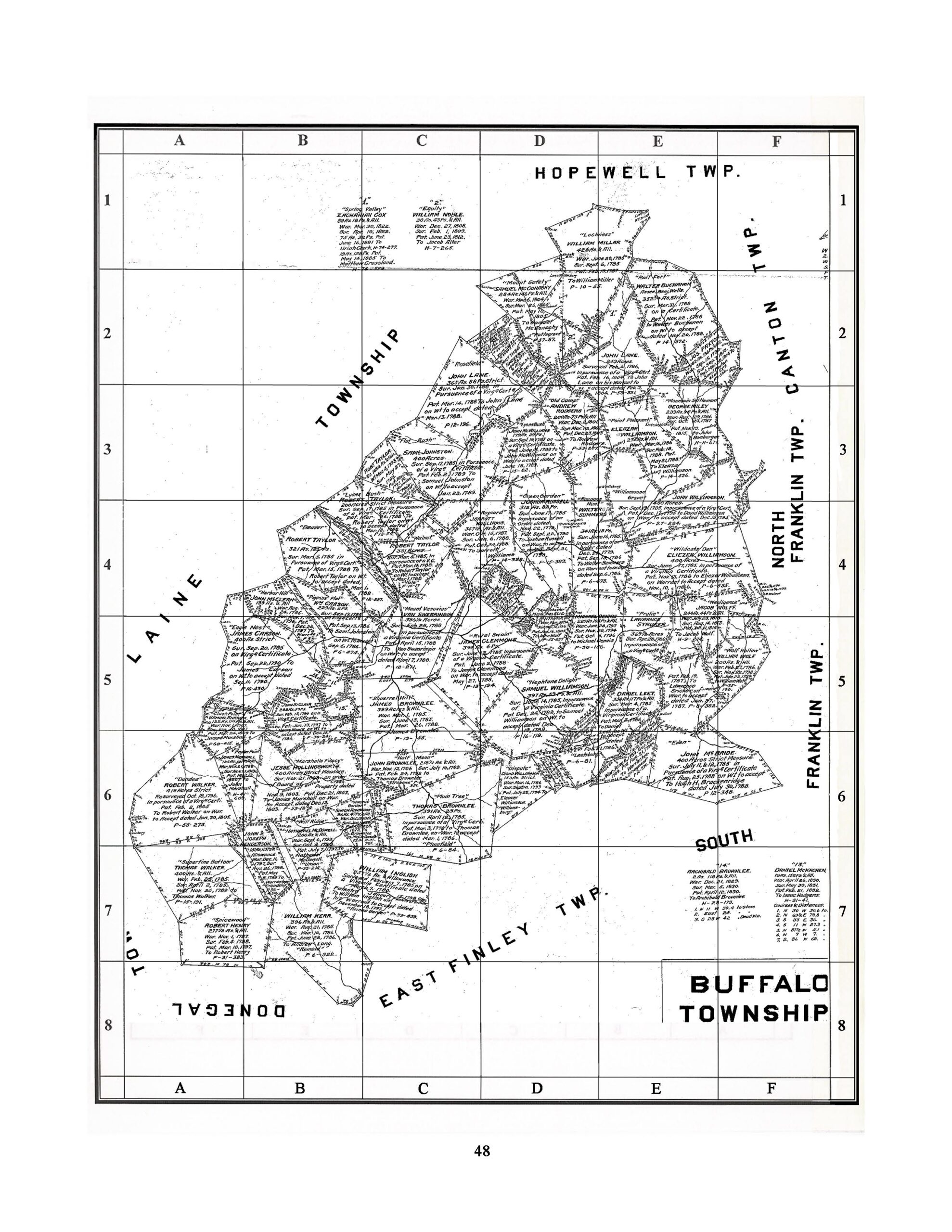
This Washington County volume of county atlases in the “Early Landowners of PA” series, contains all information shown on the 33 Township Warrantee Maps, one for each township. Each chapter begins with the Township Warrantee Map produced by the draftsmen. A second map follows, cropped to eliminate marginal information, with atlas coordinates superimposed upon it.
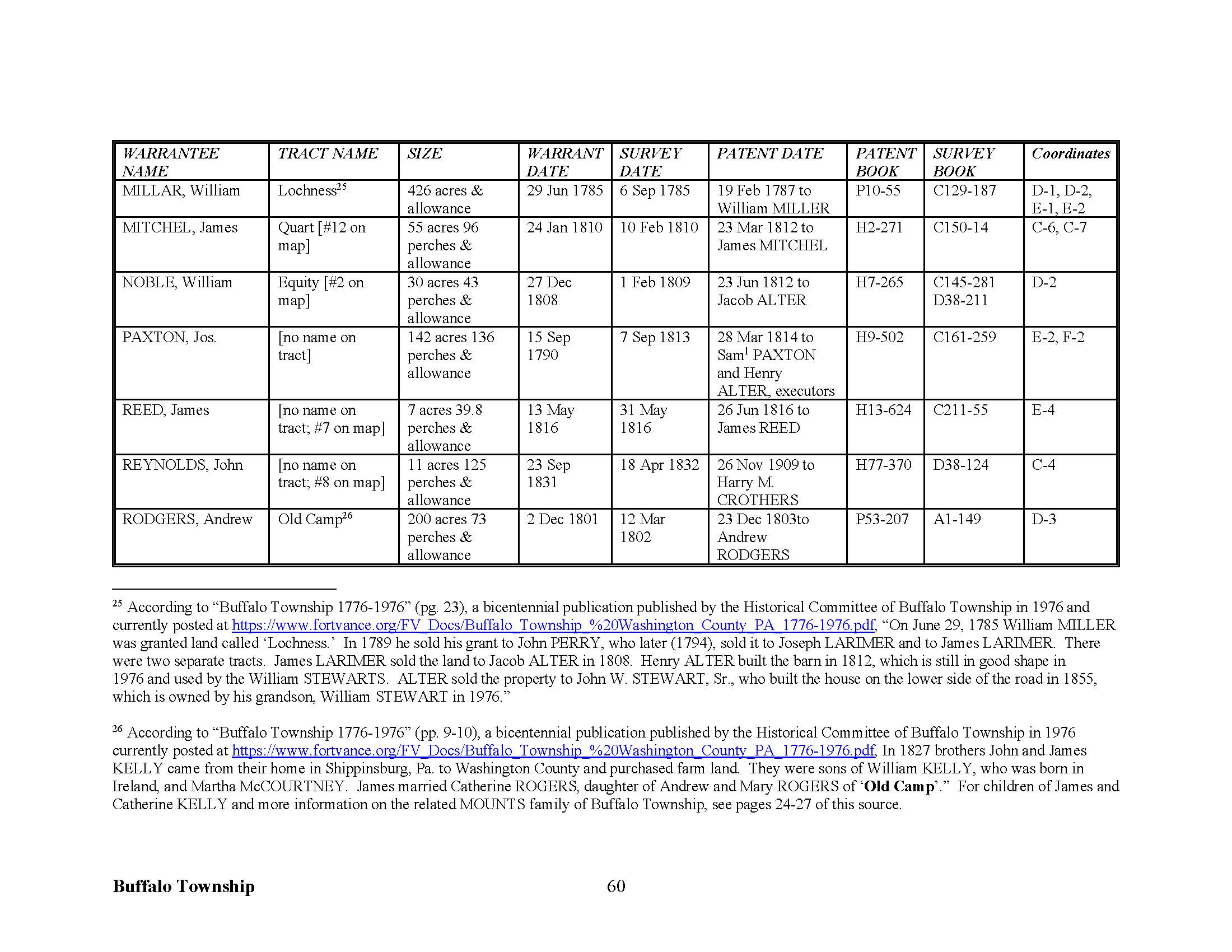
The chapter following these maps includes each fact included on every tract on the Township Warrantee Maps: names of the warrantee and patentee; size of the tract; name of the tract, if given; dates of the warrant, survey, and patent; plus the Patent Register and page number where the patent was recorded (see sample below). Finally, we added the atlas coordinates where the tract in question is located on the 2nd map.
The draftsmen, however, did not include the survey book and page number, so we recently added this information by looking up each tract in county Warrant Registers. We added numerous footnotes giving further information, including many neighbors shown on surveys at the time the survey was conducted. Some of these neighbors do not appear anywhere else in land records.
The warrantee maps show the location of the earliest landowners of the county—in other words, those who bought their land directly from the colony or state. After a tract was transferred to a private individual, subsequent transactions were recorded in the county courthouse. The maps show precise outlines in metes and bounds of each original tract and all surrounding tracts in the township, making it possible to locate allied families, baptismal sponsors, neighbors, fellow church members, and migration companions. If your ancestor was actually a first landowner in the county, purchasing his or her property directly from the colony or state of Pennsylvania, you should find him or her in this atlas.
Before your buy our Atlas of Washington County tracts, see if the name(s) you are looking for appear in free indexes of the 567-page atlas. To see if they appear in individual township chapters (each is downloadable as a separate pdf file), click on “Index to Individual Washington Co. Township Chapters by NAME” or to see the index by neighborhood, click on “Washington County Index by TOWNSHIP.”
Please note that these land transfers predate the deed books located in each county because they deal with the first transfer of land to private individuals from Pennsylvania’s colonial or state government. Once the land passed into the hands of a private owner, any subsequent transfer of the land was recorded as deeds in the county courthouse as it existed at that time. Washington County was originally part of Cumberland County (1750-1771), then Bedford County (1771-1773), and then Westmoreland County until Washington became a county of its own in 1781. Thus you may need to search those counties for deeds, wills, etc. depending on when your ancestor(s) settled here.
Examples (below) on How To Use the Atlas:
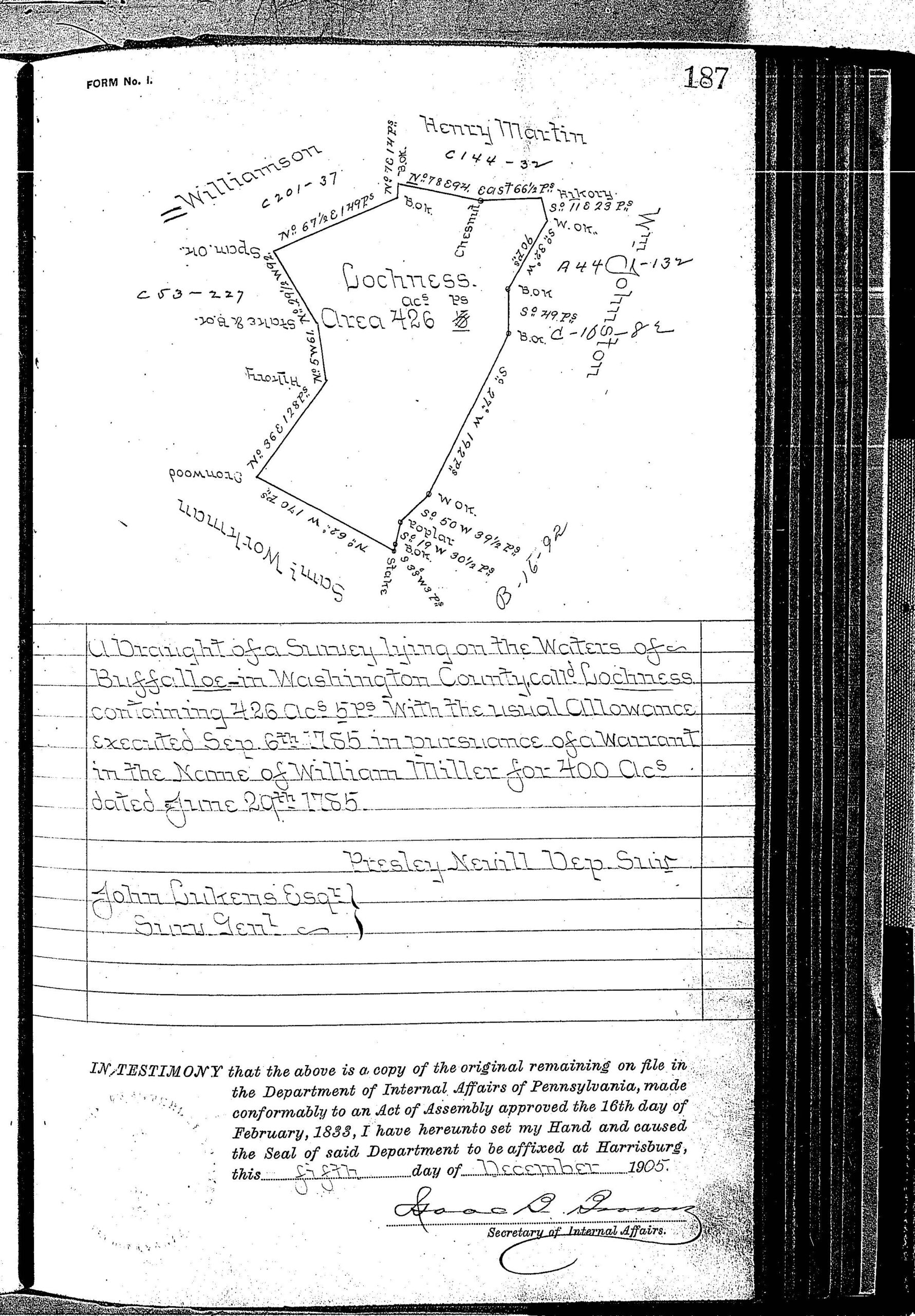
On the chapter page (left image below showing a page from the atlas), William “Millar” of Buffalo Township warranted a 426-acre tract on 29 June 1785 that was surveyed on 6 September 1785. He patented it in 1787, gave it the name “Lochness” at that time, and the patent (or final title) was recorded in Patent Book P10, pg. 55. His survey was recorded in Survey Book C129, pg. 187. Footnote #25 indicates that he sold his land to John Perry and continues with other transfers of this land.
The middle image shows Buffalo Township and we can use the coordinates to find his tract at the top of the map extending into Hopewell Township (if the image does not enlarge, right-click on it and “Open Image in New Tab” and then click on it again in order to enlarge it).
The image on the right is Miller’s survey in Survey Book C129, pg. 187, accessed by using the link for “Copied Survey Books“). We can see his neighbors as of the date of the survey (1785). It’s possible that these people are allied families, so it’s wise to open their surveys to see if you can glean more information. In this case, the name he used for his tract, “Lochness,” may indicate the area from which he came.
Note that some of his documents use the spelling “Millar” and others use “Miller” but spelling was not standardized until the 20th century. We typically used the spelling in the warrant register.
You can order the complete atlas or each of the individual township chapters below:
Atlas of Township Warrantees of Washington County (567 pages containing all township chapters, extensive intro, footnotes, index; $45 pdf download)
Allen Township (23 pages, 15 footnotes; $12.00)
Amwell Township (38 pages, 28 footnotes; ($14.00)
Blaine Township (27 pages, 31 footnotes; $14.00)
Buffalo Township (36 pages, 45 footnotes; $14.00)
Canton Township (27 pages, 28 footnotes; $14.00)
Carroll Township (27 pages, 25 footnotes; $14.00)
Cecil Township (28 pages, 32 footnotes; $14.00)
Chartiers Township (31 pages, 37 footnotes; $14.00)
Cross Creek Township (36 pages, 45 footnotes; $14.00)
Donegal Township (40 pages, 45 footnotes; $15.00)
East Bethlehem Township (34 pages, 34 footnotes; $14.00)
East Finley Township (32 pages, 19 footnotes; $14.00)
East Pike Run Township (25 pages, 16 footnotes; $12.00)
Fallowfield Township (29 pages, 35 footnotes; $14.00)
Franklin Township (35 pages, 29 footnotes; $14.00)
Hanover Township (41 pages, 37 footnotes; $14.00)
Hopewell Township (30 pages, 34 footnotes; $14.00)
Independence Township (34 pages, 40 footnotes; $14.00)
Jefferson Township (32 pages, 32 footnotes; $14.00)
Morris Township (30 pages, 7 footnotes; ($12.00)
Mount Pleasant Township (39 pages, 34 footnotes; $14.00)
North Strabane Township (36 pages, 48 footnotes; $14.00)
Nottingham Township (31 pages, 34 footnotes; $14.00)
Peters Township (28 pages, 31 footnotes; $14.00)
Robinson Township (28 pages, 25 footnotes; $12.00)
Smith Township (33 pages, 27 footnotes; $14.00)
Somerset Township (39 pages, 45 footnotes; $14.00)
South Strabane Township (33 pages, 34 footnotes; $14.00)
Union Township (32 pages, 37 footnotes; $14.00)
West Bethlehem Township, Lower (23 pages 5 footnotes; $10.00)
West Bethlehem Township, Upper (30 pages, 18 footnotes; $14.00)
West Finley Township (37 pages, 22 footnotes; $14.00)
West Pike Run Township (26 pages, 16 footnotes; $14.00)
19th-Century Residents
If your ancestors were present in Washington County in the later 1800’s, you may want to download our Caldwell’s Historical Atlas of Washington Co. of 1876 ($15). See free index here to pages for each township map and illustrations of farms stores, homes (this atlas does not include landowners shown on the township maps). This atlas has colored maps of all of the townships labeled with the names of thousands of landowners, plus black & white drawings of many towns, boroughs, as well as lithographs of private residences and farms. It also contains a “business directory” of all of the businesspeople in the county in 1876 including, for many of them, the dates they settled in Washington Co. and the place they were born. Sometimes there is surprising information in this business directory; for example, Mrs. N. McQuown is listed in Donegal Twp. as owning 10 sheep and 31 acres, Post Office Atchison, and under “Business” it states: ” John L. McQuown was born 1837, April 12th, was married to Miss Nancy M. Martin on the 24th Feb., 1866. Died Dec. 7th, 1873.” In addition to the maps showing thousands of residents of the county and the business directory of each township and town, there are illustrations of many farms, residences, and businesses in the county.
As we have done for numerous Pennsylvania counties (hover over each county on the PA map), we are posting free, downloadable township images of the 1856 Barker’s Map of Washington County, Pennsylvania, From actual surveys by James M. Sherman & A.R. Day. We hope that you will find this atlas a useful tool for when coupled with the 1850, 1860 and 1870 census and published county histories: When you find your ancestors’ tracts, your first step is to check two sources for details about their lives: (1) Boyd Crumrine’s 1882 History of Washington County, Pennsylvania which has an absolute wealth of information about early residents; (2) Alfred Creigh’s 1871 History of Washington County from its First Settlement to the Present Time; and (3) Joseph McFarland’s 1910 20th Century History of the City of Washington, and Washington County, Pennsylvania (Volume I and Volume II).
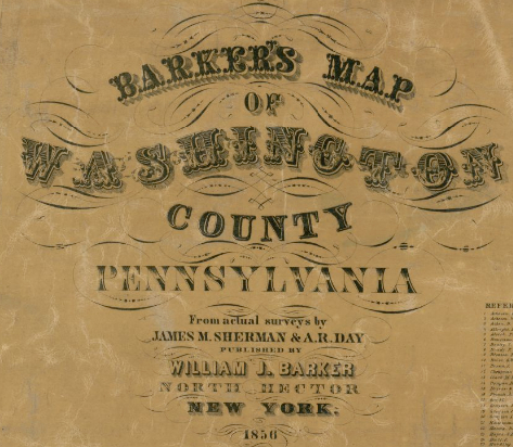
Washington County, 1856
Click on the township of your choice below. Once the images are loaded, they can be enlarged by clicking on them. If an image doesn’t enlarge, right-click on it and choose “Open Image in New Tab.” When it is opened in a new tab, you will be able to zoom in.
While the map in the Library of Congress is in the public domain, the images we have taken in the Map Room belong to us and are not to be used for commercial use. For those wishing to use them for personal use (including illustrating a family history you are working on), we give permission to use them, but we would appreciate attribution to Ancestor Tracks. It takes much time and effort to locate, process, edit, and post these and the many other county images we have posted, so we appreciate this courtesy.
Townships
Allen Township
Amwell Township
Bethlehem Township
Buffalo Township
Canton Township
Carrol Township
Cecil Township
Chartiers Township
Cross Creek Township
Donegal Township
East Finley Township
East Pike Run Township
Fallowfield Township
Franklin Township
Hanover Township
Hopewell Township
Independence Township
Jefferson Township
Morris Township
Mount Pleasant Township
North Strabane Township
Nottingham Township
Peters Township
Robeson Township
Smith Township
Somerset Township
South Strabane Township
Union Township
West Bethlehem Township
West Finley Township
West Pike Run Township